
Super Typhoon Sinlaku nears Saipan and Tinian with destructive winds, flooding and dangerous surf
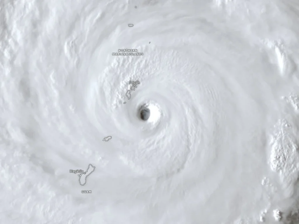
Super Typhoon Sinlaku approached Saipan and Tinian on April 14, 2026, with destructive typhoon-force winds, life-threatening coastal flooding and torrential rain expected through Wednesday. The National Weather Service said the storm’s center was just southeast of the islands Tuesday afternoon local time, with the eyewall nearing both islands and dangerous conditions already affecting parts of the Marianas.
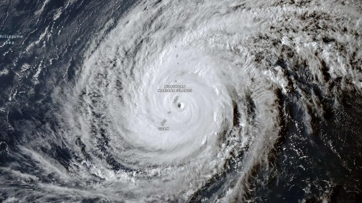
Satellite image of Super Typhoon Sinlaku at 07:00 UTC on April 14, 2026. Credit: JMA/Himawari-9, Zoom Earth, The Watchers
Key highlights:
- Sinlaku’s eyewall nears Saipan and Tinian with sustained winds of 250 km/h (155 mph).
- Life-threatening coastal flooding of 1.5–2.4 m (5–8 feet), locally up to 3–4.5 m (10–15 feet), is possible along exposed shores.
- Torrential rain and flash flooding are expected through Wednesday, with up to 380–635 mm (15–25 inches) near the storm’s center.
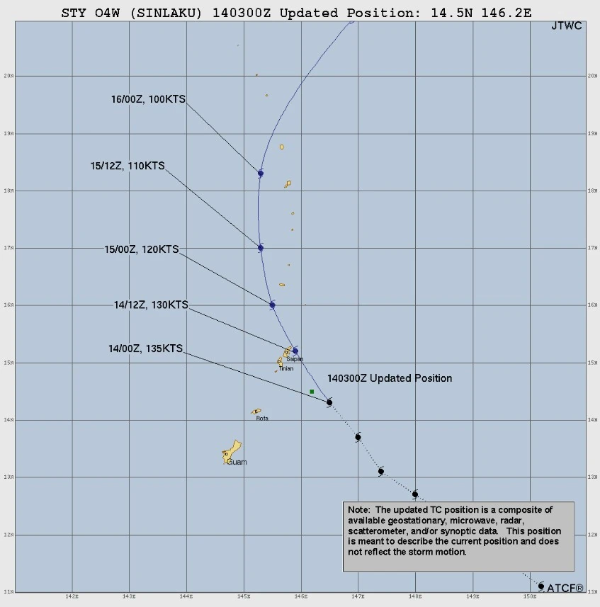
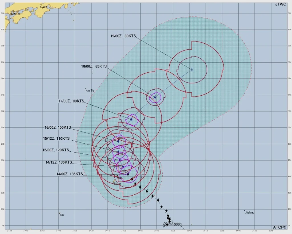
At 13:00 ChST (03:00 UTC) on April 14, the center of Sinlaku was located about 72 km (45 miles) southeast of Tinian and 80 km (50 miles) southeast of Saipan. The storm was moving northwest at 14 km/h (9 mph) with maximum sustained winds of 250 km/h (155 mph), according to the National Weather Service (NWS) and Joint Typhoon Warning Center (JTWC), who described Sinlaku as an extremely dangerous super typhoon undergoing an eyewall replacement cycle.
Forecasters said Sinlaku’s track continued to favor a passage over or very near Tinian and Saipan Tuesday night local time. Typhoon warnings remained in effect for Saipan, Tinian, Rota, Alamagan, Pagan, and Agrihan. A Tropical Storm Warning and Typhoon Watch remained in effect for Guam.
NWS warned typhoon-force winds of at least 119 km/h (74 mph) were expected to develop over Tinian and Saipan Tuesday afternoon and evening. Given Sinlaku’s intensity and core structure, destructive wind damage to roofs, power infrastructure, and exposed buildings is possible, along with prolonged utility outages and dangerous airborne debris.
A Coastal Flood Warning remains in effect until 05:00 ChST Thursday for Guam, Rota, Tinian and Saipan, while a High Surf Warning remains in effect until 18:00 ChST Thursday.
Breaking waves are forecast to reach 6-9 m (20-30 feet) at Tinian and Saipan, with significant coastal flooding of 1.5-2.4 m (5-8 feet) likely. NWS meteorologists warned wave and wind-driven surf could locally push water 3-4.5 m (10-15 feet) above normal water levels along windward shores.
The warning said numerous roads could be closed and low-lying homes, businesses and some critical infrastructure could be inundated. Shoreline erosion and dangerous surf conditions were expected across north-, east-, west- and south-facing reefs and shorelines.
Heavy rain and flash flooding are expected across the Marianas through Wednesday, April 15, with rainfall totals of 380-635 mm (15-25 inches) possible near Sinlaku’s center. Tinian and Saipan are expected to receive the heaviest rain, while Rota could see 250-510 mm (10-20 inches). Guam was forecast to receive 150-300 mm (6-12 inches), with locally higher totals.
A Flash Flood Warning remains in effect there after radar indicated 50-100 mm (2-4 inches) of rain had already fallen, with rainfall rates of 25-50 mm (1–2 inches) per hour and an additional 50-100 mm (2-4 inches) possible. Flooding of roads, streams, urban areas, and low-lying locations is possible in multiple villages, including Dededo, Tamuning, Yigo, and Mangilao.
Tropical storm-force winds were already affecting Guam and were forecast to continue into Wednesday night because of Sinlaku’s large wind field. Forecasters said sustained winds of 80-95 km/h (50-60 mph), with gusts up to 113 km/h (70 mph), were expected before conditions gradually improve later in the week.
Residents in warning areas were advised to remain in reinforced shelter and avoid travel unless absolutely necessary. NWS urged people to remain indoors during high winds, avoid all coastal areas because of life-threatening surf, and stay off flooded roads. Guam residents were told to remain sheltered until local authorities issue an all-clear.
References:
1 Super Typhoon 04W (Sinlaku) Warning #21 – JTWC – Issued at 03:00 UTC on April 14, 2026
2 Watches, Warnings & Advisories – NWS/Tiyan GU – April 14, 2026
I'm a dedicated researcher, journalist, and editor at The Watchers. With over 20 years of experience in the media industry, I specialize in hard science news, focusing on extreme weather, seismic and volcanic activity, space weather, and astronomy, including near-Earth objects and planetary defense strategies. You can reach me at teo /at/ watchers.news.
Commenting rules and guidelines
We value the thoughts and opinions of our readers and welcome healthy discussions on our website. In order to maintain a respectful and positive community, we ask that all commenters follow these rules.