
Multiple tornadoes hit Kansas, Minnesota, Iowa and Wisconsin during April 13 severe weather outbreak
A severe weather outbreak on April 13, 2026, produced at least 14 preliminary tornado reports across Kansas, Minnesota, Iowa, and Wisconsin, with the most serious reported damage in and near Ottawa. No fatalities were immediately reported, but storm surveys were still underway as forecasters warned of additional rounds of severe weather through at least April 16.

Satellite image centered over Kansas City at 23:00 UTC on April 13, 2026. Credit: NOAA/GOES-East, Zoom Earth, The Watchers
The outbreak developed during the evening after a daytime atmospheric cap weakened, allowing supercells to form along a warm front draped across the Upper Midwest and ahead of a dryline extending through the central Plains.
The Storm Prediction Center (SPC) received at least 14 preliminary tornado reports between 23:17 UTC on April 13 and 01:30 UTC on April 14, spanning four states and multiple National Weather Service (NWS) forecast areas. Kansas recorded the most significant reported impacts, with preliminary tornado reports logged near Quenemo, Pomona, Ottawa, Blue Mound, Spring Hill, Hillsdale, and near Pleasanton.
Three tornado reports were logged in southern Minnesota near Amboy, Truman, and Matawan, while three more were received in northwestern Iowa near Emmetsburg, Graettinger, and Webb. One additional preliminary tornado report came from near Hannibal in Taylor County, Wisconsin.
A delayed storm chaser report from southwest of Quenemo said a brief tornado damaged a sheet metal shed. Near Ottawa, multiple field reports described structural damage, snapped power poles, and power outages affecting parts of the city and the surrounding area, although final damage totals and tornado rating were still pending survey confirmation.
The Ottawa tornado appeared to be the most damaging event of the outbreak based on available field reports. Video from eastern Kansas showed a tornado moving near populated areas south of the city, while local damage accounts pointed to impacts on buildings and utility infrastructure. No injuries or fatalities had been confirmed as of early April 14.
The most notable tornado in Minnesota was filmed near Truman, where live weather coverage captured a tornado crossing farmland. Additional tornado reports were received near Amboy, west of Elmore, and near Matawan. A farm outbuilding was reported damaged west of Amboy.
Large hail accompanied the storms in Minnesota, with hailstones up to at least tennis-ball size reported in parts of the southern state. No injuries were immediately reported.
In Iowa, tornado reports were logged north of Emmetsburg, near Graettinger, and near Webb. Storm chasers and emergency management officials provided visual confirmation and photographs of tornadoes in Palo Alto, Emmet, and Clay counties. Preliminary data suggests the tornadoes mainly affected rural or open areas.
A tornado report was also received near Hannibal in Taylor County, Wisconsin, as intermittently lifting and touching down. Damage information from that area remained limited early April 14.
The April 13 outbreak marks the opening phase of a broader multi-day severe weather pattern expected to affect much of the central United States.
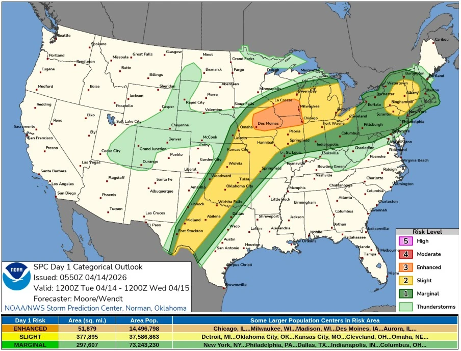
The SPC placed parts of eastern Iowa, northern Illinois, and southern Wisconsin under an Enhanced Risk for severe thunderstorms on April 14, warning of very large hail up to 5-7.5 cm (2-3 inches), damaging wind gusts, and a few tornadoes, some of them potentially strong.
“Severe thunderstorms are expected this afternoon through tonight from the southern Plains to the Great Lakes,” SPC forecasters Moore and Wendt noted. “Large to very large hail, a few tornadoes (some strong), and damaging wind gusts will be possible, particularly across parts of eastern Iowa, northern Illinois, and southern Wisconsin. Additional severe storms, mainly producing strong wind gusts, will be possible across parts of the Northeast this afternoon.”
NWS Weather Prediction Center (WPC) warned that repeated rounds of severe thunderstorms and heavy rainfall could affect the southern and central Plains, Midwest, and Great Lakes through April 16 as multiple low-pressure waves track along a frontal boundary.
Forecasters said storms would likely redevelop mainly during the afternoon and evening each day, raising the risk of flash flooding and additional tornadoes in areas already affected by the April 13 storms.
References:
1 Storm Reports for April 13, 2026 – NWS/SPC – April 14, 2026
2 Short Range Forecast Discussion – NWS/WPC – April 14, 2026
I'm a dedicated researcher, journalist, and editor at The Watchers. With over 20 years of experience in the media industry, I specialize in hard science news, focusing on extreme weather, seismic and volcanic activity, space weather, and astronomy, including near-Earth objects and planetary defense strategies. You can reach me at teo /at/ watchers.news.
Commenting rules and guidelines
We value the thoughts and opinions of our readers and welcome healthy discussions on our website. In order to maintain a respectful and positive community, we ask that all commenters follow these rules.