
Strongest hurricane wind ever measured confirmed in Hurricane Melissa
A NOAA dropsonde released into Hurricane Melissa near Jamaica on October 28, 2025, recorded a wind gust of 406 km/h (252 mph), later verified by the U.S. National Science Foundation National Center for Atmospheric Research as the strongest hurricane wind speed ever measured by a dropsonde.
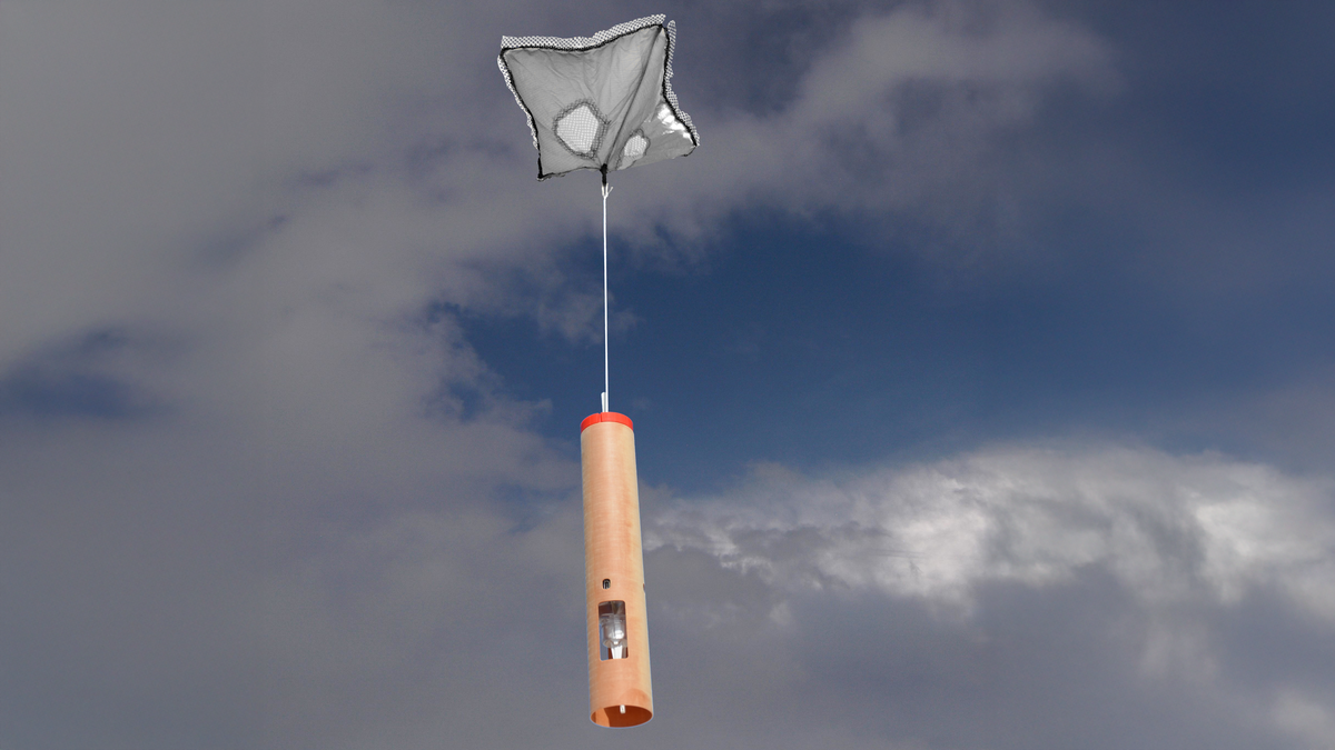
An NRD41 dropsonde, like the ones dropped into Hurricane Melissa, with Hurricane Irma in the background. Dropsonde technology is developed by NSF NCAR and manufactured by Vaisala, Credit: Holger Vömel/NSF NCAR
Hurricane Melissa was approaching Jamaica when NOAA’s Hurricane Hunter aircraft released a set of NRD41 dropsondes into the storm’s core. The devices descended beneath parachutes and sampled pressure, temperature, humidity, and wind at intervals of several seconds. One sonde captured a sudden spike to 406 km/h (252 mph) shortly before it reached the ocean, an extreme value that required immediate scrutiny.
The National Hurricane Center (NHC) received the data via satellite and recognized the measurement as unusual. Because extreme gusts can result from instrument turbulence or brief data irregularities, the center held off on making any record statements until experts could review the raw stream. The full dataset was sent to the National Science Foundation National Center for Atmospheric Research, which oversees the modern dropsonde program.
NSF NCAR scientists analyzed the descent using Aspen, a post-flight quality-control system designed to detect telemetry gaps, unrealistic wind shifts, and inconsistencies in measured variables. The evaluation showed a smooth descent, complete data transmission, and no physical contradictions in the wind profile. Everything aligned with conditions expected inside a powerful tropical cyclone.
“NOAA looped us in when they saw the high wind speed and asked, ‘Are these numbers any good?’,” said Holger Vömel of NSF NCAR. He emphasized that reconnaissance crews work in hazardous environments and rely on accurate processing of the data they collect. The verified result placed Melissa’s gust at the top of the global dropsonde record.
Why this extreme gust matters for science and forecasting
A real 406 km/h (252 mph) gust is valuable for understanding how the most dangerous winds form in the lowest layers of a hurricane. Aircraft cannot safely fly in this part of the storm during category 4 or category 5 conditions, leaving dropsondes as the only direct sensor capable of sampling the near-surface environment where impacts are greatest.
Melissa’s measurement helps refine the relationship between instantaneous gusts and sustained winds used in operational intensity estimates. These relationships influence hurricane categories, structural damage models, and risk communication. Data of this kind provides a clearer picture of how strong winds concentrate around the eyewall.
Dropsondes record several variables at a rapid rate, revealing small turbulent structures not captured by satellite or radar. These details feed numerical weather prediction models and help identify eyewall features that control rapid intensification or weakening. The Melissa gust will be used to evaluate how well high-resolution simulations represent wind extremes.
The measurement also improves understanding of the exchange of heat and momentum between the ocean and atmosphere. The boundary layer influences storm surge, rainfall distribution, and overall cyclone structure. Having accurate data inside this region allows researchers to better link near-surface conditions to surface impacts.
Verified extreme values are rare because high-end hurricanes offer few safe opportunities for in-storm sampling. Melissa’s gust now serves as a key datapoint for future research into tropical cyclone dynamics and intensity forecasting.
Inside the NRD41 dropsonde that captured the record
Dropsondes are compact cylindrical instruments designed to fall vertically through storms while continuously transmitting environmental data. The modern system was developed at NSF’s NCAR about 50 years ago and has undergone multiple generations of refinement. Today, the NRD41, manufactured by Vaisala, is the standard instrument for hurricane reconnaissance worldwide.
As the NRD41 falls, it captures pressure, temperature, humidity, and GPS-derived wind from the aircraft’s release altitude down to the sea surface. The measurements form a complete vertical profile that cannot be obtained by any remote sensing system. Satellites observe only indirect information, while radar is limited near the surface by sea spray and turbulence.
Deploying multiple dropsondes gives forecasters a detailed picture of how the storm evolves over time. Vertical profiles show where wind maxima occur, how the eyewall tilts, and how humidity layers shift, all of which affect intensity forecasts. This information is critical when storms approach populated coastlines.
“When you’re looking at a category 4 or 5 hurricane, you’re not going to have an airplane flying that close to the surface – that would be totally unsafe – but you need to know what is happening near sea level because that’s where people and property are most affected,” said Terry Hock, who manages the dropsonde program at NSF NCAR. “The dropsonde gets you information you can’t get any other way, and that’s why it’s been around for decades.”
The consistency of the NRD41 platform also supports scientific comparison across storms and years. Its stable design and sampling characteristics allow researchers to evaluate extreme values like Melissa’s in a global context.
What past storms reveal about extreme winds
Before Melissa, the strongest verified dropsonde gust came from Typhoon Megi in 2010, where a sonde measured 399 km/h (248 mph) as it fell through the eyewall. That reading passed similar quality control steps and remained the global record for more than a decade.
Other storms have produced candidate measurements that failed scrutiny. During Hurricane Katrina in 2005, a dropsonde appeared to record an extremely high gust, but closer analysis revealed problems with the data. That value was removed from the record, and the case remains an example of why independent verification is necessary.
Evaluating extreme winds across different cyclones requires consistent instrumentation and analysis methods. The NRD41 platform enables this consistency, giving scientists confidence when comparing rare extreme gusts between storms in different ocean basins.
Melissa’s verified value will likely factor into the National Hurricane Center’s post-season reanalysis of the storm. These assessments revisit storm intensity and structure to ensure the historical record accurately reflects observed conditions. Verified measurements anchor those evaluations and help improve long-term hurricane climatology.
The Melissa event is expected to influence future studies exploring how intense cyclones concentrate their strongest winds. Researchers will use these observations to refine models of eyewall structure, turbulence, and peak wind distribution.
Impacts on Jamaica, Haiti and the Caribbean
Hurricane Melissa produced widespread destruction across Jamaica, Haiti, and neighboring islands. Communities experienced major damage from strong winds, storm surge, and intense rainfall. Infrastructure failures included damaged homes, flooded roadways, and prolonged power and communication outages.
Close to one hundred fatalities occurred across the region. Forecast accuracy played a role in preventing a larger disaster, as timely warnings allowed many residents to evacuate or take protective actions. Dropsonde data contributed to these forecasts by helping meteorologists assess the storm’s evolving wind field.
While the record gust was measured above the surface, it reflects the storm’s internal intensity and the destructive potential that reached communities along its path. The measurement provides context for why certain areas experienced severe damage while others saw more moderate conditions.
Post-storm analysis will combine dropsonde profiles with satellite imagery, radar data, and ground observations to reconstruct Melissa’s near-surface wind field. This work supports improvements in hazard modeling and helps inform building standards and resilience planning for future storms.
Recovery efforts remain ongoing across the affected islands. The event highlighted structural vulnerabilities in the region and the need for stronger preparedness strategies. Melissa’s impacts will inform future risk reduction policies as Caribbean nations work to rebuild.
References:
1 Record-breaking winds confirmed for Hurricane Melissa – NSF NCAR – November 19, 2025

I’m a science journalist and researcher at The Watchers, contributing to the Epicenter edition, where I cover peer-reviewed scientific research and emerging discoveries across Earth and space sciences. With a background in astronomy and a passion for environmental science, I’ve worked in shark and coral conservation in Fiji, conducting reef and shark-behavior research, contributing to mangrove restoration, and earning PADI Open Water and Coral Reef Certifications. I bring a blend of scientific rigor and storytelling to illuminate the discoveries shaping our planet and beyond.
I understand how vitally important these dropsondes are. My question is about the environmental impact of these pieces of equipment once they fall into the water.
Do they float, do they sink, do they break-up or dissolve ? Can they be retrieved for reuse (probably not). What effect do / will the small parts have on local wildlife, etc. This equipment is obviously vitally important and necessary for it’s task, especially in a period of global warming initiated or worsened by human-caused climate disruption, but I would like to know if it is yet another part of the human chain of environmental pollution.