
Jamaica declared a disaster area after Hurricane Melissa leaves over half a million without power
The historic landfall of Hurricane Melissa over Jamaica on October 28, 2025, has left behind a trail of destruction, prompting authorities to declare the island a disaster area on October 29. Over half a million people were left without power as Melissa ripped through the island. While some fatalities have been reported in Jamaica, official confirmation is yet to be made.
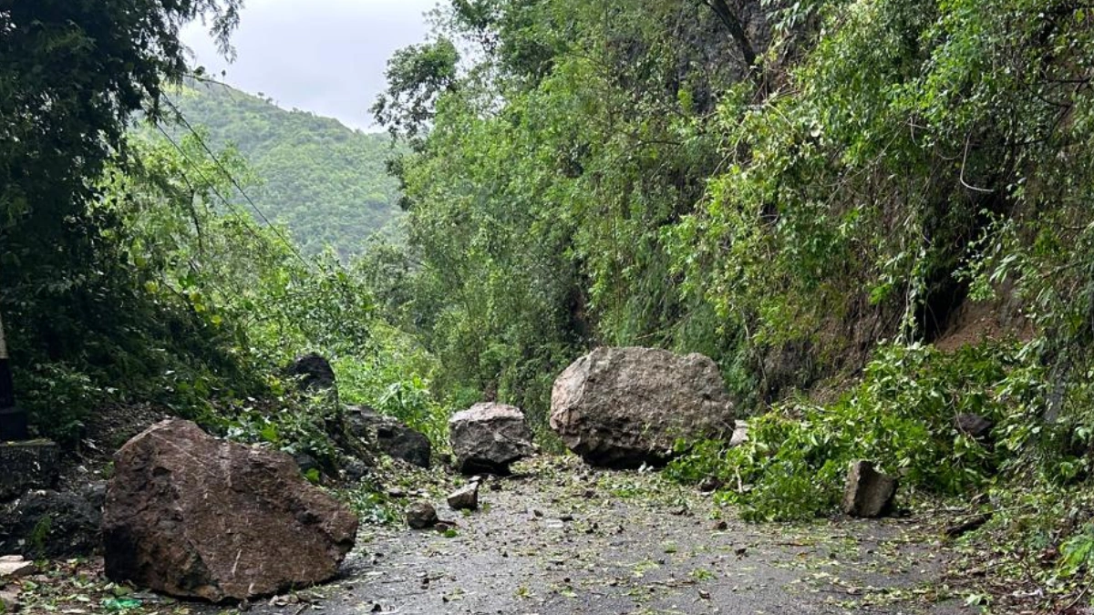
Rockfall in Jamaica following Hurricane Melissa's landfall on October 28, 2025. Credit: NWA Jamaica
Category 5 Hurricane Melissa made historic landfall over southwestern Jamaica near New Hope at 17:00 UTC (12:00 local time) on October 28. Melissa is one of the most powerful hurricane landfalls on record in the Atlantic basin.
The National Hurricane Center (NHC) reported maximum sustained winds of about 295 km/h (185 mph) and a minimum central pressure of 892 hPa, at the time of landfall. Melissa was the strongest storm to hit Jamaica since records began in 1851.
The system formed from a tropical wave in mid-October over the eastern Atlantic. Warm sea-surface temperatures above 29°C (84°F), low vertical wind shear, and favorable upper-level outflow promoted rapid intensification as the system moved west.
On October 27, the storm strengthened explosively south of Hispaniola and reached Category 5 intensity before landfall along Jamaica’s southern coast.
Thousands of homes were destroyed or had their roofs lost due to the destructive winds from Melissa. The hardest hit Parishes included Clarendon, Saint Catherine, and the Manchester parish. Nearly 15 000 people were in shelters in Jamaica, and some 540 000 customers, or 77%, were without power, officials said.
Approximately 6 000 people were residing in 382 official shelters. Evacuation centers remain open in southern and central parishes, where floodwaters and debris have delayed return to homes.
Hospitals in Kingston and Mandeville sustained damage but continued limited operations under backup power. The Norman Manley International Airport in Kingston remained closed through October 29 due to runway flooding, while Sangster International Airport in Montego Bay resumed partial service later that day.
Prime Minister Andrew Holness declared states of emergency in seven heavily affected parishes, calling the destruction “unprecedented in scope.” The entire island of Jamaica was declared a disaster area by the Prime Minister.
An all-clear was issued on October 29, after the storm passed through the island, signaling all utility companies to commence restoration and recovery operations.
“Crews from the JPS (Jamaica Public Service), NWC (National Water Commission), NWA (National Works Agency), and also our telecommunications companies and other critical services have now and will be advised to mobilise immediately to restore electricity, water, and communication networks,” said Minister Dana Morris Dixon in a press conference.
While fatalities have been reported in Jamaica, the exact number remains unclear. At least three fatalities have been confirmed in Jamaica as of October 29, while over 30 have been reported in total.
National response teams, including the Jamaica Defence Force, Fire and Rescue Service, and public works crews, began clearing debris and restoring critical access routes. The government’s National Emergency Operations Centre remains fully activated.
The Caribbean Disaster Emergency Management Agency (CDEMA) deployed assessment teams, while the International Federation of Red Cross and Red Crescent Societies (IFRC) and World Food Programme (WFP) initiated logistics for emergency relief.
The United States Agency for International Development (USAID) announced technical assistance to support power restoration and supply chain recovery. Neighboring governments in the Caribbean also offered material and medical support.
Official damage assessments are ongoing and will be available as recovery operations continue.
The Office of Disaster Preparedness and Emergency Management (ODPEM) reported that restoration priorities include power and water supply, reopening main transport corridors, and clearing debris from urban centers. The Ministry of Health and the Ministry of Education began damage assessments on hospitals and schools.
The Bank of Jamaica and the Ministry of Finance are conducting a national economic loss assessment. As of this report, no verified damage estimate has been released. Severe crop losses have been reported. Banana, sugarcane, and poultry production in southern parishes are among the worst hit.
The Hurricane later made a second landfall near Santiago de Cuba, at Chivirico, as a Category 3 Hurricane.

As of 11:00 EDT (15:00 UTC) on October 29, Melissa was located about 245 km (152 miles) south of the Central Bahamas and approximately 1 615 km (1 003 miles) southwest of Bermuda.
Maximum sustained winds (averaged over one minute) reached 155 km/h (96 mph). The storm’s estimated minimum central pressure was 974 hPa, and it was moving northeast at 22 km/h (14 mph).
Melissa is forecast to move across the southeastern or central Bahamas today and pass near or to the west of Bermuda later on October 30.
Heavy rainfall will continue tapering off this afternoon across eastern Cuba. Storm total rainfall of 250 to 510 mm (10 to 20 inches), with isolated maxima up to 635 mm (25 inches) over mountainous terrain, is expected.
Across the Southeast Bahamas, storm total rainfall of 125 to 250 mm (5 to 10 inches) is expected today, likely resulting in areas of flash flooding. For the Turks and Caicos, 25 to 75 mm (1 to 3 inches) of rain is expected. Heavy rainfall may begin to affect Bermuda on October 30.
Rainfall has diminished across Jamaica; however, additional scattered showers remain possible, with 50 to 100 mm (2 to 4 inches) of additional rainfall expected.
This will bring storm total amounts to 300 to 610 mm (12 to 24 inches), with isolated areas reaching 760 mm (30 inches) over mountainous terrain. Ongoing catastrophic flash flooding and numerous landslides are expected to continue through tonight, according to the NHC.

I am an Assistant Editor and Severe Weather & Science Journalist at The Watchers, specializing in real-time severe weather coverage, geophysical event reporting, and research-driven scientific analysis. You can reach me at rishav(at)watchers(.)news.
Commenting rules and guidelines
We value the thoughts and opinions of our readers and welcome healthy discussions on our website. In order to maintain a respectful and positive community, we ask that all commenters follow these rules.