
Deadly Hurricane “Irma” devastates Caribbean islands, enormous catastrophe reported
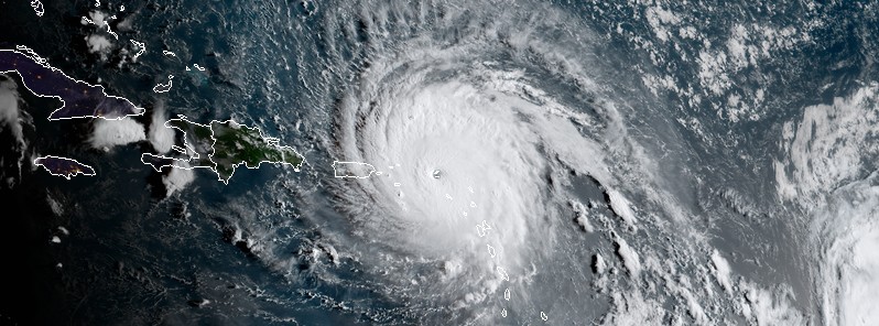
Featured image: Hurricane "Irma" at 11:30 UTC on September 6, 2017. Credit: NOAA/GOES-16 (preliminary and non-operational)
The eye of Category 5 Hurricane "Irma" passed over the small Caribbean islands of Antigua and Barbuda, one of the most prosperous Caribbean nations, around 06:00 UTC on September 6, 2017 with maximum sustained winds of 298 km/h (185 mph).
Irma then continued toward St. Barthélemy and St. Martin, equally strong, and then toward the British Virgin Islands and Puerto Rico.
As of 09:00 UTC on September 7, the hurricane has claimed at least 10 lives and the death toll is expected to rise.
Over the past 24 hours, Hurricane "Irma" has maintained maximum sustained winds of 185 mph), longer than any Atlantic hurricane on record. In fact, as of early September 7 (UTC), Irma has had winds of 298 km/h (185 mph) for 33 hours. No other tropical cyclone around the globe has been this strong for so long in satellite era (since 1966).
On its path toward Florida, Irma is expected to pass directly over the Turks and Caicos Islands and The Bahamas, still as a Category 5 hurricane, pushing a storm surge of seawater 4.6 to 6 m (15 to 20 feet).
This is expected to happen within the next 72 hours, and Irma is expected to approach Florida late Saturday or early Sunday, September 10, as extremely dangerous Category 4 hurricane.
Island by island reports
Anguilla
At least one person died in Anguilla (population 12 316), British overseas territory, where police stations, hospitals, school facilities, three or four emergency shelters, a home for the infirm and the aged, as well as the fire station, along with many homes, had been damaged or destroyed. The British government has been accused of a failure to respond speedily to the devastation.
Antiqua and Barbuda
According to authorities, initial reports out of Barbuda (population 1 800) mention 95% of homes are damaged or destroyed and at least one person killed. Visiting Barbuda, Prime Minister Gaston Browne said it's absolute devastation.
"The island is literally under water. In fact, I'm of the view that, as it stands now, Barbuda is barely habitable".
"The telecommunications system in Barbuda was wiped out and cell towers were knocked over," Browne said. "Both the island's hotels were demolished," he added. Recovery efforts are expected to take months or years.
On the other hand, its sister island Antigua (population 80 161) escaped major damage, with no loss of life.
St. Barthélemy
The French government has confirmed widespread flooding and power outages on the island. The damage in St. Barthélemy (population 9 279) is being described as "devastating" and "apocalyptic."
St. Martin
St. Martin (population 36 824) authorities say the island is almost completely destroyed. At least 8 people have been killed there, and the death toll is expected to rise.
"It's an enormous catastrophe – 95% of the island is destroyed," top local official Daniel Gibbs was quoted as saying. The French interior minister, Gérard Collomb, said the four sturdiest buildings on St. Martin had been destroyed, "which means that in all likelihood the more rustic buildings are probably totally or partially destroyed." Government offices in St. Martin have been partially destroyed.
Devastating damage was also reported in the Dutch section of St. Martin, known as Sint-Maarten (population 40 917). Their airport, the third largest in the Caribbean, has been destroyed.
British Virgin Islands
The British Virgin Islands sustained significant damage, too, as the center of the hurricane passed right over its northern region. Reports from the islands are still scarce, but we know that critical facilities, homes, businesses, and supermarkets have been devastated.
U.S. Virgin Islands
US president declared a state of emergency in US Virgin Islands, which was also struck by Irma, although without landfall. There are reports, however, of extensive damage to buildings, and of land entirely stripped of vegetation.
Puerto Rico
Powerful winds and heavy rain left most of Puerto Rico (population 3.7 million) without power, tens of thousands without water and many areas under flash flooding. The center of Hurricane "Irma" passed just north of the island.
Hurricane "Irma" – September 2017
Current conditions and forecast
Irma is still extremely dangerous, potentially catastrophic hurricane, now moving toward the Turks and Caicos Islands, The Bahamas and eventually Florida where Governor Rick Scott already declared a state of emergency and issued mandatory evacuation orders for Miami Dade and Monroe Counties and voluntary for Broward and Collier Counties. Additional orders are expected as the storm nears the state.
Officials from Turks and Caicos to Florida pleaded with people to heed advisories to evacuate to shelters and higher ground. Hubert Minnis, the prime minister of Bahamas, said they are evacuating people from six islands to the capital Nassau, in the largest storm evacuation in the country's history.
At 06:00 UTC (02:00 AST), the center of Hurricane "Irma" was located 225 km (140 miles) NW of San Juan, Puerto Rico and 410 km (255 miles) ESE of Grand Turk Island. The system has maximum sustained winds of 290 km/h (180 mph) and is moving WNW at 26 km/h (16 mph). It has a minimum central pressure of 921 hPa.
Some fluctuations in intensity are likely during the next day or two, but Irma is forecast to remain a powerful category 4 or 5 hurricane during the next couple of days.
Hurricane-force winds extend outward up to 85 km (50 miles) and tropical-storm-force winds up to 295 km (185 mph).
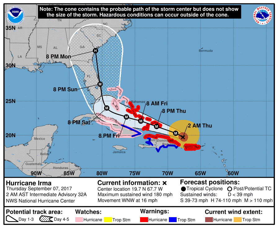
A Hurricane Warning is in effect for:
- Puerto Rico, Vieques, and Culebra
- Dominican Republic from Cabo Engano to the northern border with Haiti
- Haiti from the northern border with the Dominican Republic to Le Mole St. Nicholas
- Southeastern Bahamas and the Turks and Caicos Islands
- Central Bahamas
A Hurricane Watch is in effect for:
- Cuba from Matanzas province eastward to Guantanamo Province
- Northwestern Bahamas
A Tropical Storm Warning is in effect for:
- Dominican Republic from south of Cabo Engano westward to the southern border with Haiti
- Haiti from south of Le Mole St. Nicholas to Port-Au-Prince
- Cuba provinces of Guantanamo, Holguin, and Las Tunas
Storm surge
The combination of a life-threatening storm surge and large breaking waves will raise water levels ABOVE NORMAL TIDE LEVELS by the following amounts within the hurricane warning area near and to the north of the center of Irma. Near the coast, the surge will be accompanied by large and destructive waves.
Turks and Caicos Islands: 4.6 to 6 m (15 to 20 feet)
Southeastern and central Bahamas: 4.6 to 6 m (15 to 20 feet)
Northern coast of the Dominican Republic: 0.9 to 1.5 m (3 to 5 feet)
Northern coast of Haiti and the Gulf of Gonave: 0.3 to 0.9 m (1 to 3 feet)
Northern coast of Cuba in the warning area: 1.5 to 3 m (5 to 10 feet)
The combination of a life-threatening storm surge and the tide will cause normally dry areas near the coast to be flooded by rising waters moving inland from the shoreline. The water is expected to reach the following HEIGHTS ABOVE GROUND if the peak surge occurs at the time of high tide:
Northern coast of Puerto Rico: 0.6 to 1.2 m (2 to 4 feet)
Southern coast of Puerto Rico: 0.3 to 0.9 m (1 to 3 feet)
Water levels in the U.S. and British Virgin Islands will gradually subside tonight and early Thursday.
The deepest water will occur along the immediate coast in areas of onshore winds, where the surge will be accompanied by large and destructive waves. Surge-related flooding depends on the relative timing of the surge and the tidal cycle, and can vary greatly over short distances.
Wind
Tropical Storm and Hurricane conditions will continue over portions of Puerto Rico for the next few hours. Hurricane conditions are expected to begin within the hurricane warning area in the Dominican Republic and Haiti today, with tropical storm conditions beginning in the next few hours.
Hurricane conditions are expected to begin in the warning area in the southeastern Bahamas and the Turks and Caicos Islands later today with tropical storm conditions expected within the next several hours.
These conditions will spread into the Central Bahamas by Thursday night or early Friday.
Hurricane and tropical storm conditions are possible within the watch area in Cuba by Friday. Tropical storm conditions are expected to begin within the warning area in Cuba Thursday night.
Rainfall
Irma is expected to produce the following rain accumulations through Saturday:
Northern Leeward Islands: Additional 25.4 to 76.2 mm (1 to 3 inches). Storm total 203.2 to 304.8 mm (8 to 12 inches), isolated 508 mm (20 inches).
Northeast Puerto Rico and the British and U.S. Virgin Islands: 152.4 to 304.8 mm (6 to 12 inches), isolated 508 mm (20 inches).
Southwest Puerto Rico: 76.2 to 152.4 mm (3 to 6 inches), isolated 254 mm (10 inches).
The Southern Leeward Islands, and Saint Croix: 50.8 to 101.6 mm (2 to 4 inches).
Southeast Bahamas, Central Bahamas, and the Turks and Caicos: 203.2 to 304.8 mm (8 to 12 inches), isolated 508 mm (20 inches).
Northern Dominican Republic and northern Haiti: 101.6 to 254 mm (4 to 10 inches), isolated 381 mm (15 inches).
Eastern and Central Cuba: 101.6 to 254 mm (4 to 10 inches), isolated 381 mm (15 inches).
Southwest Haiti: 25.4 to 101.6 mm (1 to 4 inches).
In all areas, this rainfall may cause life-threatening flash floods and mudslides.
Surf
Swells generated by Irma will affect the northern Leeward Islands, Puerto Rico, the Virgin Islands, the southeastern Bahamas, the Turks and Caicos Islands, the northern coast of the Dominican Republic, and portions of the southeast coast of the United States during the next several days.
These swells are likely to cause life-threatening surf and rip current conditions.
Hurricane "Irma" Meteorological Records / Notable Facts Recap
through September 7 at 03:00 UTC
Intensity measures
- 298 km/h (185 mph) lifetime max winds – tied with Florida Keys (1935), Gilbert (1988) and Wilma (2005) for second strongest max winds of all time in Atlantic hurricane. Allen had max winds of 305.7 km/h (190 mph) in 1980.
- 298 km/h (185 mph) lifetime max winds – making it the strongest storm on record to impact the Leeward Islands, defined as 15-19°N, 65-60°W for this calculation. Okeechobee Hurricane (1928) and David (1979) were previous strongest at 257 – 298 km/h (160 mph – 185 mph) lifetime max winds – the strongest storm to exist outside of the Caribbean and Gulf of Mexico on record.
- 298 km/h (185 mph) max winds for 33 hours – the longest any cyclone around the globe has maintained that intensity on record. The previous record was Haiyan in the NW Pacific at 24 hours.
- 914 hPa lifetime minimum central pressure – lowest since Dean (2007) and 10th lowest in satellite era (since 1966).
- 914 hPa lifetime minimum central pressure – lowest pressure by an Atlantic hurricane outside of the western Caribbean and Gulf of Mexico on record.
- First Category 5 hurricane in the Atlantic since Matthew (2016) and first Category 5 hurricane in the tropical Atlantic (7.5-20°N, 60-20°W) since Hugo (1989).
- 1.75 days as a Category 5 hurricane – tied with David (1979), Mitch (1998) and Isabel (2003) for 4th most Category 5 hurricane days on record.
Integrated measures
- Generated the most Accumulated Cyclone Energy by a tropical cyclone on record in the tropical Atlantic (7.5-20°N, 60-20°W).
- Generated more Accumulated Cyclone Energy than the first eight named storms of the Atlantic hurricane season (Arlene-Harvey) combined.
- Generated the most Accumulated Cyclone Energy in a 24-hour period on record, breaking old record set by Allen (1980).
- Generated the most Accumulated Cyclone Energy by a named storm forming in August since Frances (2004).
- Generated 3.75 major hurricane days in the tropical Atlantic (7.5-20°N, 60- 20°W) – trailing only Luis (1995) for major hurricane days in the tropical Atlantic.
Note: Lifetime refers to storm lifetime to date.
After Irma comes Jose
Hurricane "Irma" is being slowly trailed by Hurricane "Jose," anticipated to affect the northern Leeward Islands in a couple of days.
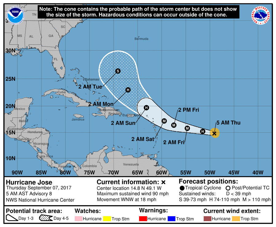
At 09:00 UTC (05:00 AST) the center of Hurricane "Jose" was located 1 310 km (815 miles) E of The Lesser Antilles. Jose's maximum sustained winds are 150 km/h (90 mph). The system is moving WNW at 30 km/h (986 inches).
I'm a dedicated researcher, journalist, and editor at The Watchers. With over 20 years of experience in the media industry, I specialize in hard science news, focusing on extreme weather, seismic and volcanic activity, space weather, and astronomy, including near-Earth objects and planetary defense strategies. You can reach me at teo /at/ watchers.news.
Commenting rules and guidelines
We value the thoughts and opinions of our readers and welcome healthy discussions on our website. In order to maintain a respectful and positive community, we ask that all commenters follow these rules.