
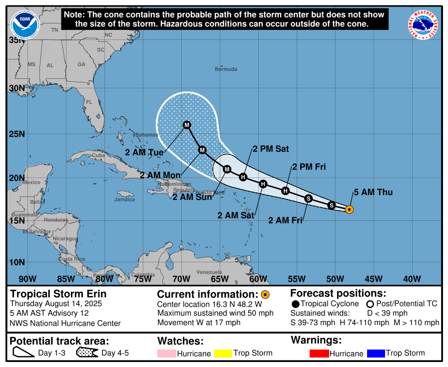
Erin forecast to become major hurricane north of Puerto Rico and the Virgin Islands
Tropical Storm Erin is forecast to strengthen into the first hurricane of the 2025 Atlantic season by August 15, 2025, and could reach major hurricane strength early next week as it moves near or just north of the northern Leeward Islands. The system is prompting early emergency preparations in the U.S. Virgin Islands despite no projected landfall, with forecasters warning of dangerous surf and rip currents across the Caribbean and potentially along the U.S. East Coast.
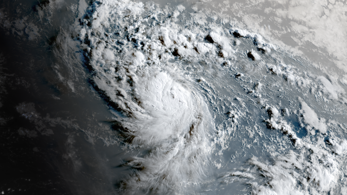
Satellite image of Tropical Storm Erin at 09:50 UTC on August 14, 2025. Credit: NOAA/GOES-East, RAMMB/CIRA, The Watchers
Tropical Storm Erin is forecast to become the first hurricane of the 2025 Atlantic hurricane season by August 15 and pass near or just north of the northern Leeward Islands over the weekend.
The overall environment around Erin is conducive for gradual strengthening during the next day or so. Thereafter, the system is forecast to move across warmer waters, and the GFS and EC SHIPS guidance suggests a slight decrease in shear.
“This increasingly favorable environment could result in a period of rapid intensification, which is explicitly forecast between 24 and 48 hours,” NHC forecaster Kelly noted. Wind shear may slightly increase later this weekend, although sea surface temperatures remain around 29°C (8°F), with favorable divergence aloft.
Most of the intensity guidance continues to show strengthening during this time frame at a steady rate, with Erin forecast to become a major hurricane by Sunday, August 17.
Although the storm is not expected to make landfall, preparations for its effects are underway in the U.S. Virgin Islands as the system continues to organize.
Even with its forecast track distance over 320 km (200 miles), the National Weather Service (NWS) warned of dangerous seas, rip currents, and potential flooding from heavy rain.
The Virgin Islands Territorial Emergency Management Agency (VITEMA) stated that territory-wide sand distributions, initially scheduled to begin next week, have been moved up to August 14, 15, and 16.
At 05:00 AST (09:00 UTC) on August 14, Erin was located approximately 1 593 km (990 miles) east of the northern Leeward Islands. Maximum sustained winds reached 80 km/h (50 mph), with an estimated minimum central pressure of 1 002 hPa.
Tropical storm-force winds extended outward up to 97 km (60 miles) from the center and the storm was moving westward at 28 km/h (17 mph).
The storm is expected to continue moving westward through August 14, with a west-northwestward motion forecast overnight and continuing through the weekend.
Swells generated by Erin are expected to affect parts of the northern Leeward Islands, the Virgin Islands, and Puerto Rico by the weekend, causing life-threatening surf and rip current conditions.
In addition to the Caribbean, forecasters warn that swells from Erin are likely to propagate northward into the western Atlantic, reaching the U.S. East Coast within the next several days. These swells could produce dangerous surf and rip current conditions along beaches from Florida to the Mid-Atlantic, even though the storm is not forecast to make landfall in the United States.
Hurricane Hunters are scheduled to fly into Tropical Storm Erin on Friday to gather more data on the development.
The storm triggered deadly flash floods in São Vicente Island, Cabo Verde on August 11 while it was still designated Invest 97L. At least 9 fatalities were confirmed by the Ministry of Education, with over 190 mm (7.5 inches) of rain falling in just 5 hours. The floods displaced over 1 500 people and affected more than 3 000.
The World Bank has accepted Cabo Verde’s request for emergency assistance to support recovery efforts in the islands of São Vicente, São Antão, and São Nicolau.
The assistance was activated through an instrument under the Cabo Verde Resilient and Equitable Recovery DPF with Cat DDO, allowing for the immediate disbursement of SDR 7.9, equivalent to USD 10 million.

I’m a science journalist and researcher at The Watchers, contributing to the Epicenter edition, where I cover peer-reviewed scientific research and emerging discoveries across Earth and space sciences. With a background in astronomy and a passion for environmental science, I’ve worked in shark and coral conservation in Fiji, conducting reef and shark-behavior research, contributing to mangrove restoration, and earning PADI Open Water and Coral Reef Certifications. I bring a blend of scientific rigor and storytelling to illuminate the discoveries shaping our planet and beyond.
Commenting rules and guidelines
We value the thoughts and opinions of our readers and welcome healthy discussions on our website. In order to maintain a respectful and positive community, we ask that all commenters follow these rules.