
Moderate-to-strong atmospheric river to impact Pacific Northwest and southern British Columbia
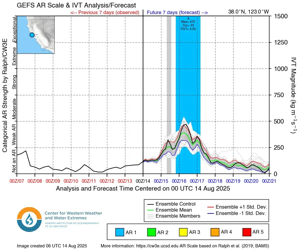
An atmospheric river (AR) with moderate-to-strong integrated vapor transport (IVT) exceeding 500 kg m⁻¹ s⁻¹ is forecast to make landfall over the Pacific Northwest and southern British Columbia on the evening of August 14, 2025, bringing sustained AR conditions for about 24 hours and significant precipitation through August 16.
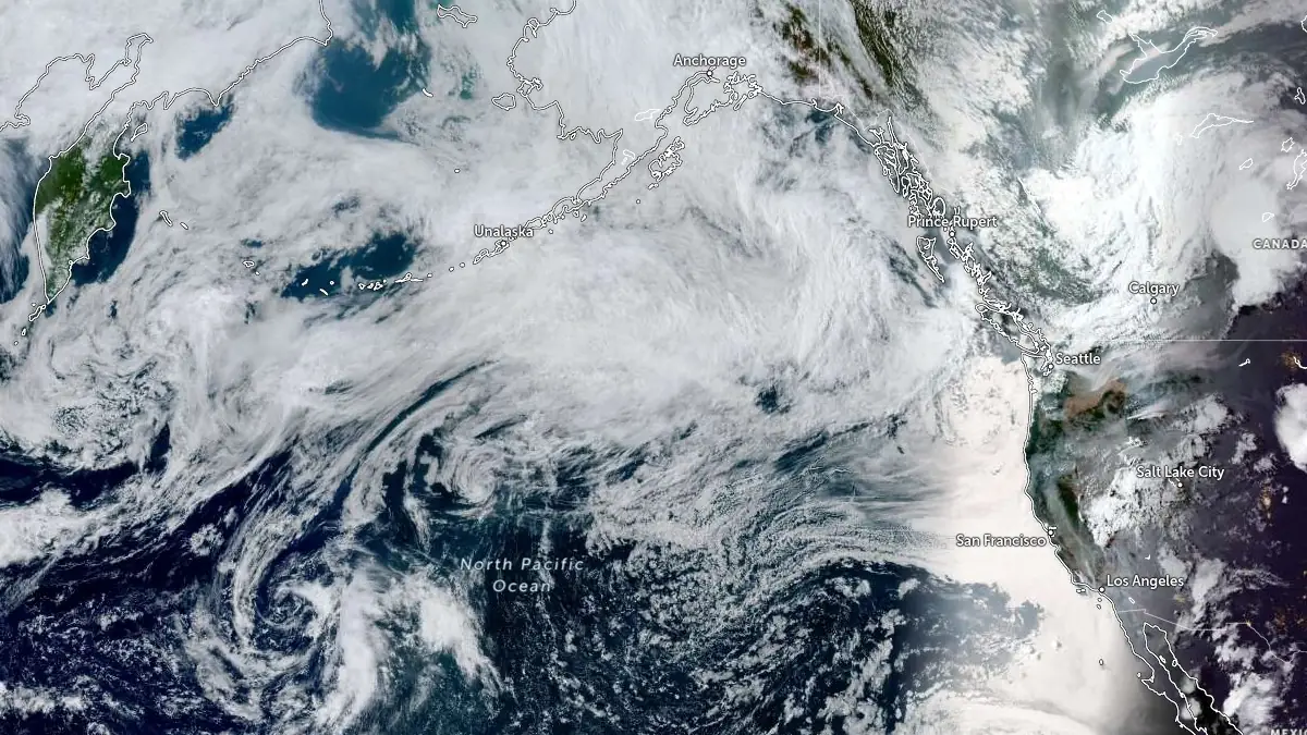
Satellite image acquired at 01:20 UTC on August 14, 2025. Credit: NOAA/GOES-West, Zoom Earth, The Watchers
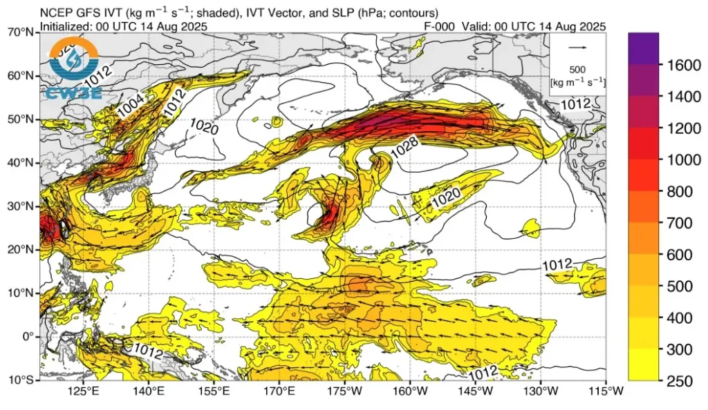
According to the Center for Western Weather and Water Extremes (CW3E) AR Landfall Tool, there is a near 100% probability of IVT above 250 kg m⁻¹ s⁻¹ along the coasts of Washington, Oregon, and southern British Columbia between August 14 and 16.
The tool also shows an 80–90% probability of IVT above 500 kg m⁻¹ s⁻¹ from central Washington to central Oregon late on August 15.
The 12:00 UTC Global Ensemble Forecast System (GEFS) control run indicates AR 2–3 conditions (on a scale of 1 –5) along coastal Washington and Oregon from about 05:00 LT (12:00 UTC) on August 14 through 05:00 LT (12:00 UTC) on August 16.
Approximately 60% of GEFS members forecast AR 3–4 conditions near the Washington–Oregon border at 46°N, 124°W.

The National Weather Service Weather Prediction Center (NWS WPC) forecasts 72-hour precipitation totals ending 05:00 LT (12:00 UTC) on August 17 of 50–100 mm (2–4 inches) across the coastal mountains and Cascades in Washington, with local maxima exceeding 125 mm (5 inches) in the upper elevations of the Olympic Peninsula.
The European Centre for Medium-Range Weather Forecasts (ECMWF) Ensemble Prediction System (EPS) and GEFS ensemble means show strong agreement in coastal precipitation forecasts but less agreement for Cascade foothill watersheds.
The AR is expected to propagate over a high-pressure system in the northeast Pacific, limiting impacts to the Pacific Northwest and adjacent British Columbia coast.
Streamflow responses are expected to remain below flood thresholds due to prolonged drought conditions.
The U.S. Drought Monitor identifies areas of extreme drought east of the Washington Cascades, where the forecast precipitation may help to alleviate conditions and support wildfire suppression efforts.
However, the degree of relief will depend on rainfall distribution and infiltration rates across the drought-affected watersheds.
Understanding atmospheric rivers and IVT
Atmospheric rivers (ARs) are powerful streams of water vapor in the atmosphere that deliver torrential rain and snow to the Pacific Northwest and British Columbia, often triggering floods, landslides, and widespread disruptions.
These “rivers in the sky” carry immense amounts of moisture from the Pacific Ocean, impacting coastal areas and inland mountain ranges.
To understand their scale, consider Integrated Vapor Transport (IVT), which measures how much water vapor moves through the atmosphere, expressed as kilograms transported per meter of width per second (kg/m/s).
For example, in a typical AR hitting the PNW or BC, a 1-meter-wide slice might carry 500 kg of water vapor per second—about 1 100 pounds. For an AR spanning 800 km (500 miles), common for those striking the region, this equates to roughly 400 million kg (400 000 metric tons) of water vapor flowing every second, about 19 times the average flow of the Mississippi River.
When ARs collide with the Cascade Mountains, the moist air rises, cools, and unleashes heavy precipitation. In November 2021, a powerful AR drenched BC’s Fraser Valley and Washington’s Whatcom County, with places like Hope, BC, receiving over 250 mm (9.8 inches) of rain in 48 hours and parts of northwest Washington seeing similar deluges. This led to severe flooding, mudslides, and road closures, including sections of the I-5 corridor and BC’s Highway 1.
The high IVT values in these events, often 500 kg m⁻¹ s⁻¹ or more, explain why ARs can overwhelm rivers, infrastructure, and communities across the Pacific Northwest and British Columbia.
I'm a dedicated researcher, journalist, and editor at The Watchers. With over 20 years of experience in the media industry, I specialize in hard science news, focusing on extreme weather, seismic and volcanic activity, space weather, and astronomy, including near-Earth objects and planetary defense strategies. You can reach me at teo /at/ watchers.news.
Commenting rules and guidelines
We value the thoughts and opinions of our readers and welcome healthy discussions on our website. In order to maintain a respectful and positive community, we ask that all commenters follow these rules.