
Severe thunderstorms and flooding threat forecast across the Plains through Thursday
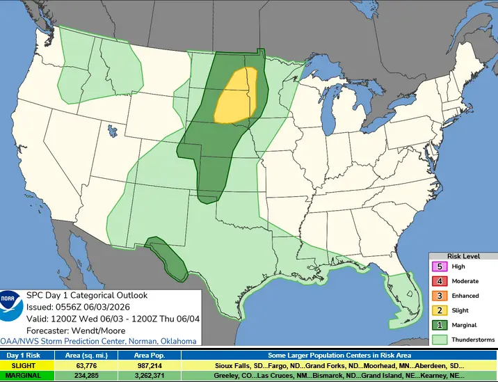
Repeated rounds of severe thunderstorms are forecast to develop across parts of the northern Plains and Upper Mississippi Valley through Thursday, June 4, bringing the potential for large hail, damaging winds, isolated tornadoes, and localized flooding. The Storm Prediction Center (SPC) placed parts of the eastern Dakotas and western Minnesota under a Slight Risk (level 2 of 5) for severe thunderstorms, while excessive-rainfall outlooks from the Weather Prediction Center (WPC) target portions of the eastern Dakotas, west Texas, and New Mexico.
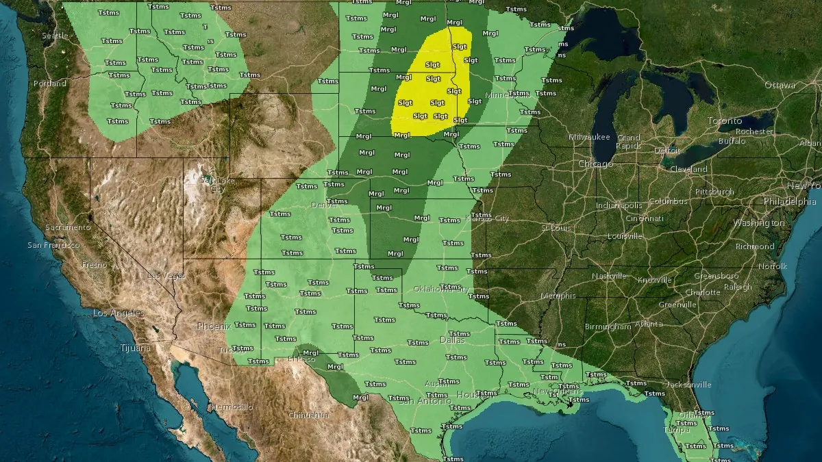
Convective Outlook valid 24 hours to 14:00 EDT on June 4, 2026. Credit: NWS/SPC
Severe thunderstorms capable of producing large hail, damaging winds, a limited tornado threat, and localized flooding are forecast across parts of the northern Plains and Upper Mississippi Valley through Thursday, June 4, as repeated rounds of thunderstorms develop along a slow-moving frontal boundary.
Additional severe storms are also possible across parts of the central High Plains, southwest Texas, and southeast New Mexico, while heavy rainfall could lead to flooding in the eastern Dakotas and parts of west Texas and New Mexico.
A stalled boundary across the Plains will remain the focus for repeated thunderstorm development through Thursday, according to the WPC. Moisture moving northward from the Gulf of Mexico and a series of weather disturbances crossing the northern United States will support multiple rounds of showers and thunderstorms across the Plains and southern Rockies.
The greatest severe-weather threat on Wednesday extends from the eastern Dakotas into western Minnesota, where the SPC has placed the region under a Slight Risk (level 2 of 5) for severe thunderstorms. Thunderstorms developing during the afternoon and evening may produce large to very large hail and damaging wind gusts.
A cluster of thunderstorms near the Nebraska–South Dakota border early Wednesday may affect the timing and intensity of storm development later in the day. Cloud cover left behind by morning storms may delay daytime heating in some locations and slow the development of stronger thunderstorms during the afternoon.
Initial supercells may produce the largest hail and the greatest tornado threat before consolidating into a line of thunderstorms moving southeastward. As that transition occurs, damaging winds are expected to become the primary hazard, although large hail may remain possible with the strongest storms.
WPC has issued a Slight Risk (level 2 of 4) for excessive rainfall across the eastern Dakotas and from west Texas into New Mexico. Repeated thunderstorms moving over the same locations could produce high rainfall rates and localized flooding. A broader Marginal Risk (level 1 of 4) covers parts of the southern Rockies and much of the Plains.
Outside the northern Plains, SPC notes that isolated severe thunderstorms are also possible across parts of the central High Plains, southwest Texas, and southeast New Mexico. In those areas, the strongest storms could produce large hail and damaging wind gusts.
Across the central and southern Plains, weak disturbances moving east from the Southwest are forecast to interact with the stalled boundary across the High Plains. Widespread severe weather is not expected, but some storms may organize into clusters capable of producing damaging wind gusts in localized areas and isolated large hail.
Forecast confidence is lower across southwest Texas, where conditions during the morning may determine whether stronger storms form later in the day. If cloud cover and showers persist through the morning, storm development during the afternoon could be limited. If sunshine becomes more widespread and temperatures rise, thunderstorms capable of producing large hail and damaging wind gusts could develop near the Davis Mountains and Big Bend region.
The threat is expected to continue on Thursday as a secondary front moves into the Plains and northern Rockies. Additional rounds of thunderstorms are forecast to develop along and ahead of the front, prolonging both severe-weather and flooding concerns. SPC expands the Slight Risk area for severe thunderstorms into northern Nebraska on Thursday, while WPC continues to highlight portions of the Plains, Upper Midwest, and Texas for excessive rainfall potential.
Farther east, high pressure centered over the Ohio Valley and Mid-Atlantic will keep much of the eastern United States dry through Thursday. A stationary front near the Gulf Coast and Florida is forecast to support daily afternoon and evening showers and thunderstorms during the next few days.
Temperatures are forecast to remain above normal across parts of the eastern United States, generally reaching about 21 to 32°C (70s and 80s°F).
Across the Southwest, highs are expected to climb to about 38 to 41°C (low to mid 100s°F). Areas affected by increased cloud cover and thunderstorms across New Mexico and Texas are forecast to remain cooler, with highs mainly near 27 to 32°C (80s°F) through Thursday.
By the end of the week, above-normal warmth is forecast to expand from parts of the Southwest and Upper Midwest into the Mid-Atlantic and Northeast.
References:
1 Short Range Public Discussion – NWS/WPC – June 3, 2026
2 Day 1 Convective Outlook – NWS/SPC – June 3, 2026

I’m a science journalist and researcher at The Watchers, contributing to the Epicenter edition, where I cover peer-reviewed scientific research and emerging discoveries across Earth and space sciences. With a background in astronomy and a passion for environmental science, I’ve worked in shark and coral conservation in Fiji, conducting reef and shark-behavior research, contributing to mangrove restoration, and earning PADI Open Water and Coral Reef Certifications. I bring a blend of scientific rigor and storytelling to illuminate the discoveries shaping our planet and beyond.
Commenting rules and guidelines
We value the thoughts and opinions of our readers and welcome healthy discussions on our website. In order to maintain a respectful and positive community, we ask that all commenters follow these rules.