
More than 300 mm (11.8 inches) of rain triggers flooding, evacuations, and dam overflow in South Africa
More than 301 mm (11.9 inches) of rain fell in parts of South Africa’s Garden Route after an intense cut-off low brought flooding, evacuations, road closures, and infrastructure damage across the Western and Eastern Cape from May 5–7, 2026. At least one person died in Knysna, hundreds were affected in Garden Route shelter operations, and emergency shelters were opened across flood-affected parts of Nelson Mandela Bay and the Eastern Cape.
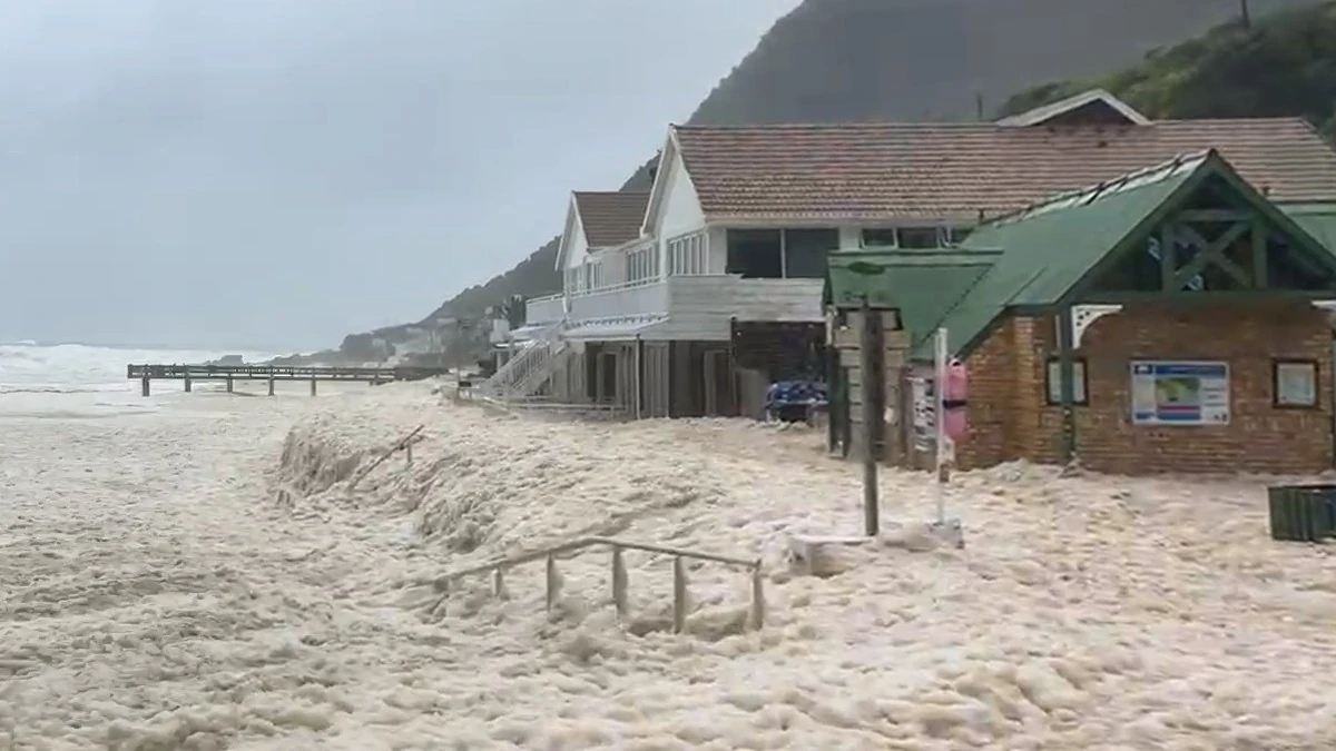
Heavy wave action elevated sea conditions Victoria Bay resulted in seawater pushing up past the public restrooms and into surrounding areas on May 6, 2026. Credit: Garden Route District Municipality
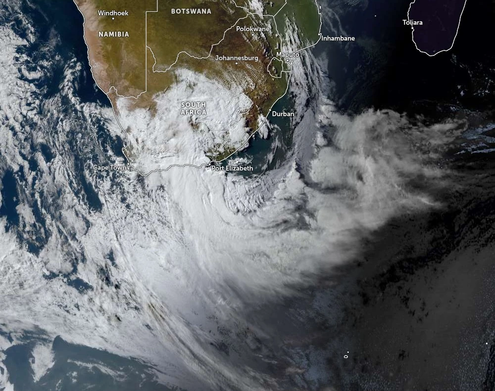
An intense cut-off low that triggered South Africa’s highest-impact rainfall warnings earlier this week produced widespread flooding, evacuations, road closures, and infrastructure damage across parts of the Western and Eastern Cape between May 5 and 7.
The system brought more than 301 mm (11.9 inches) of rain to parts of the Garden Route, forced evacuations in the Gamtoos Valley after Kouga Dam exceeded capacity, and left communities cut off across several districts.
The South African Weather Service (SAWS) warned on May 5 that the slow-moving storm could generate prolonged heavy rainfall, damaging winds, hazardous coastal conditions, and flooding across multiple provinces.
Orange Level 8 warnings, the highest issued during the event, were activated for parts of the Garden Route, Kouga, and Koukamma as authorities warned that rainfall totals of 150–200 mm (5.9–7.9 inches) could isolate communities, inundate roads, and sharply increase river and dam levels.
By Thursday, May 7, the forecast impacts evolved into a major multi-region flood emergency affecting the Garden Route, Karoo, Nelson Mandela Bay, Kouga, and other parts of the Eastern Cape.
At least one person died in Knysna after a tree fell onto her vehicle during the storm, hundreds were affected by shelter operations in the Garden Route District, and emergency response teams continued rescue, evacuation, and infrastructure assessment operations across flood-affected areas.
The Garden Route District Municipality’s multi-agency command center said Thursday that weather warnings had been downgraded from Level 8 to Level 6, although Knysna, Bitou, and George/Langkloof remained areas of concern as rivers, dams, and catchments continued responding to several days of heavy rainfall.
Stormdrift and Kammanassie dams began spilling overnight, increasing flows through the Groot River system toward Meiringspoort, Oudtshoorn, Calitzdorp Hot Springs, and Gouritz. Authorities warned that some roads and low-water crossings could remain inaccessible even as rainfall gradually subsided.
The highest verified rainfall total was recorded at Joubertina, where cumulative rainfall since Monday, May 4, reached 301.2 mm (11.9 inches). Other major totals included 286.8 mm (11.3 inches) at Knysna Kleingrysbos, 285.6 mm (11.2 inches) at Knysna Diepwalle, 276.8 mm (10.9 inches) at Plett Newlands, 239.2 mm (9.4 inches) at Stormsrivier Forest Fern, 222.8 mm (8.8 inches) at Stormsrivier Witteklip, and 219.2 mm (8.6 inches) at Witfontein.
Road closures affected the Garden Route and Karoo today, after flooding and increased water flow disrupted several routes, including Meiringspoort, Swartberg Pass, the N9, the Avontuur–Haarlem road, Robinson Pass from the Oudtshoorn side, and several district and provincial roads.
The multi-agency command center said Meiringspoort could remain inaccessible for an extended period because of recorded damage.
Emergency teams expanded evacuation and assessment operations today into cut-off areas of Oudtshoorn, Kannaland, George, and Bitou after flooding isolated several communities.
Affected locations there included Middelplaas, Volmoed, Cango Bergoord, De Oude Meul, Moeras River, Proefplaas, Paardebont near Van Wyksdorp, Mount Hope, and SNK/Fisantehoek, where South African National Defence Force personnel, Oudtshoorn Fire Department crews, South African Police Service divers, EMS Metro teams, and a medical rescue helicopter assisted with access, evacuations, and field assessments.
Around 450 people remained affected by severe weather in the Garden Route District, where shelter operations were underway in Kranshoek, Wittedrift, Hornlee Community Hall, Masefundi Library, Loerie Park, Sedgefield, Smutsville, Chris Hani, Toekomsrus/Welgeluk/GG Kamp/Black Joint, and De Rust.
Eastern Cape impacts intensified after Kouga Dam exceeded full capacity and reached 113% on Thursday, prompting urgent evacuation notices for parts of the Gamtoos Valley. Residents were told to evacuate Kingsway Village, Big Fish, Gamtoos Mouth Resort, Ferry Hotel, and low-lying areas in the valley.
The Kuga Municipality officials have strongly advised farmers to relocate livestock, farming equipment, machinery and vehicles urgently to safer areas to avoid severe flood damage.
“Please avoid all river crossings and flooded roads. Emergency teams remain on high alert and residents are requested to cooperate with all evacuation instructions,” the municipality said. “Your safety comes first. Do not attempt to drive or walk through flowing water,” the municipality said.
Shelters were opened at Katrina Felix Hall in Thornhill and Loerie Community Hall.
Nelson Mandela Bay’s disaster response remained active after flooding affected several wards, including KwaZakhele, Motherwell, Kariega, KwaDwesi, Bethelsdorp, Missionvale, and KwaNobuhle. Emergency shelters and community centers were opened for displaced residents while relief organizations distributed food, blankets, and emergency supplies. Municipal officials said no fatalities or serious injuries had been reported in the metro as of Wednesday evening.
Ndlambe Local Municipality also reported widespread flood damage to homes and infrastructure. Municipal speaker Andile Marasi said several roads were affected, residents were receiving essentials including blankets, and damage assessments were continuing.
SANParks earlier closed activities in the Garden Route National Park because of heightened flood risk. Water-based recreation and hiking were suspended in the Wilderness Section, hiking and cycling trails were closed in the Knysna Section, and the Otter and Waterfall trails were closed in the Tsitsikamma Section while officials monitored river levels, estuaries, rainfall intensity, coastal conditions, and tidal conditions.
References
1 Level 8 disruptive rainfall warnings issued for Eastern and Western Cape, South Africa – The Watchers – May 5, 2026
2 Garden Route | Karoo storms: Garden Route Multi-Agency Command Centre update 7 May – Knysna-Plett Herald – May 7, 2026
3 BREAKING NEWS: Urgent evacuation order issued for Gamtoos Valley as Kouga Dam hits 113% – Nova News – May 7, 2026
I'm a dedicated researcher, journalist, and editor at The Watchers. With over 20 years of experience in the media industry, I specialize in hard science news, focusing on extreme weather, seismic and volcanic activity, space weather, and astronomy, including near-Earth objects and planetary defense strategies. You can reach me at teo /at/ watchers.news.
Commenting rules and guidelines
We value the thoughts and opinions of our readers and welcome healthy discussions on our website. In order to maintain a respectful and positive community, we ask that all commenters follow these rules.