
Tornado Emergency issued as large tornado hits Brookhaven area, Mississippi
A large, destructive tornado moved through the Brookhaven area of southern Mississippi during the evening of May 6, 2026, after the National Weather Service in Jackson issued a Tornado Emergency for communities including Brookhaven and Bogue Chitto. The event developed within an SPC Enhanced Risk severe weather setup and produced repeated radar-confirmed Tornado Debris Signatures as the storm moved from Franklin County into Lincoln County and toward Lawrence County.
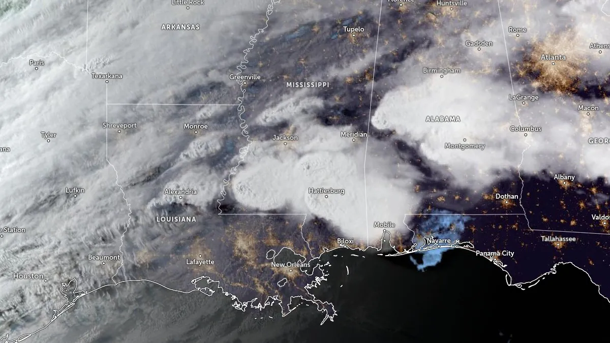
Satellite image centered over Jackson, MS acquired at 23:50 UTC on May 6, 2026. Credit: NOAA/GOES, Zoom Earth, The Watchers
The outbreak developed along a frontal boundary across the Lower Mississippi Valley, where anomalous Gulf moisture and strengthening wind shear created conditions favorable for severe thunderstorms and tornado-producing supercells across Mississippi during the afternoon and evening of May 6.
The Storm Prediction Center (SPC) placed much of central and southern Mississippi under an Enhanced Risk for severe weather, including a 10% probability area for significant tornadoes, while NWS Jackson warned that storms would be capable of strong tornadoes, damaging winds up to 113 km/h (70 mph), large hail, and flash flooding.
Forecast discussions issued before the outbreak warned that discrete supercells developing ahead of an advancing storm system would be capable of producing strong tornadoes, large hail, and damaging winds as instability and wind shear intensified across the Lower Mississippi Valley during the afternoon and evening hours.
NWS Jackson warned repeatedly throughout the day that severe storms and heavy rain were expected from the afternoon into early May 7, with hazards including tornadoes, some strong, damaging wind gusts up to 113 km/h (70 mph), hail up to golf-ball size, and flash flooding. Threat updates issued through the afternoon showed increasing concern for tornado development across western and central Mississippi as storms organized along and ahead of the advancing system.
The most significant tornado activity developed near Meadville and Brookhaven during the evening. NWS warning text described a “large and destructive tornado” near Meadville around 19:09 CDT, moving east at about 80 km/h (50 mph).
A Tornado Emergency was issued for Bude, Meadville, McCall Creek, Brookhaven, and Bogue Chitto as the circulation moved eastward from Franklin County toward Lincoln County.
Storm chasers, including Reed Timmer, reported a massive wedge tornado approaching areas south of Brookhaven as the circulation neared Interstate 55. Videos from storm chasers and residents showed a large tornado crossing south of the city with a broad debris field.
Footage from Brookhaven later showed damaged buildings, snapped and uprooted trees, debris scattered across streets, and emergency crews moving through damaged areas overnight.
Unconfirmed reports of fatalities circulated overnight following the Brookhaven-area tornado, including reports tied to a trailer park near the city, but officials had not released a confirmed fatality total as of 06:40 UTC on May 7.
Radar-confirmed debris signatures continued across the Brookhaven corridor as the storm tracked eastward. SPC tornado reports logged Tornado Debris Signatures near West Lincoln at 00:37 UTC on May 7, east of West Lincoln at 00:49 UTC, near Enterprise at 00:57 UTC and 01:03 UTC, and near Harmony at 01:14 UTC. Another debris-signature report was later logged near Monticello in Lawrence County at 01:26 UTC.
Franklin County Emergency Management reported multiple homes destroyed and residents trapped in damaged structures as emergency operations continued during dangerous nighttime conditions. Downed trees were also reported along Interstate 55 between Brookhaven and Bogue Chitto, with debris blocking roads in several locations.
Additional severe-weather reports continued elsewhere across southern Mississippi after the Brookhaven-area tornado. SPC later logged major building damage along MS Highway 589 and Old Highway 11 near Purvis in Lamar County, where an emergency manager also reported damage to an office building. Other reports included trees down near Dixie in Forrest County and power flashes and flying debris near Prentiss in Jefferson Davis County.
Additional storms and heavy rain are forecast across parts of the Southeast and Lower Mississippi Valley through the end of the week as the frontal boundary responsible for the May 6 outbreak continues to shift across the region.
NWS Weather Prediction Center said renewed thunderstorm development on Friday could produce localized flash flooding where repeated rainfall overwhelms already saturated soils, with severe-weather potential continuing farther south and east of the Brookhaven damage corridor.
Update
14:24 UTC, May 7
Damage assessments cited by Gov. Tate Reeves showed more than 200 homes damaged in Lincoln County, 275 homes and 50 apartment units damaged or inaccessible in Lamar County, and 12 homes damaged in Lawrence County. Reeves also said 30 roads were closed in Lamar County because of debris, while multiple roads in Lawrence County were blocked by downed trees and power lines.
According to the Mississippi Emergency Management Agency, at least 17 people were injured during the storms, including 12 transported from the Wash Trailer Park in Bogue Chitto after severe damage was reported there overnight.
References:
1 SPC Storm Reports for May 6, 2026 – NWS/SPC – May 7, 2026
2 Enhanced Risk of severe thunderstorms from Louisiana through Mississippi into Alabama on May 6 – The Watchers – May 6, 2026
3 Short Range Forecast Discussion – NWS/WPC – May 7, 2026
I'm a dedicated researcher, journalist, and editor at The Watchers. With over 20 years of experience in the media industry, I specialize in hard science news, focusing on extreme weather, seismic and volcanic activity, space weather, and astronomy, including near-Earth objects and planetary defense strategies. You can reach me at teo /at/ watchers.news.
Commenting rules and guidelines
We value the thoughts and opinions of our readers and welcome healthy discussions on our website. In order to maintain a respectful and positive community, we ask that all commenters follow these rules.