
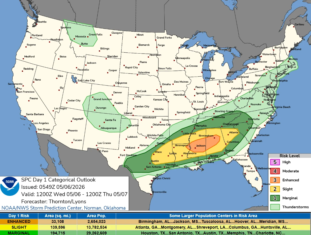
Enhanced Risk of severe thunderstorms from Louisiana through Mississippi into Alabama on May 6
An Enhanced Risk (Level 3/5) of severe thunderstorms has been issued for parts of the Lower Mississippi Valley on May 6, 2026, as forecasters warned that storms capable of producing damaging winds, large hail, and tornadoes are expected to develop from the Southern Plains into the Southeast. Heavy rainfall rates of 25 to 50 mm (1 to 2 inches) per hour may also accompany stronger storms across the region.
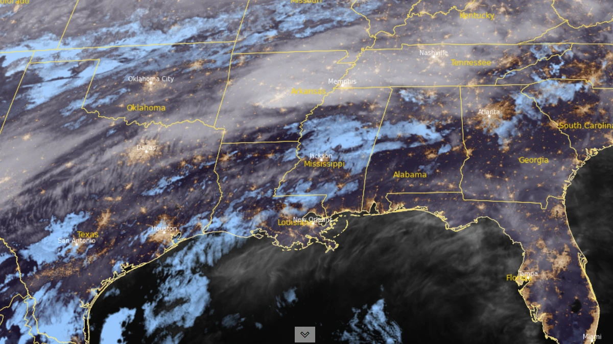
Satellite image of southeastern USA at 08:10 UTC on May 6, 2026. Credit: NOAA-GOES-19, RAMMB/CIRA, The Watchers
An Enhanced Risk (Level 3/5) of severe thunderstorms has been issued for parts of northern Louisiana, central Mississippi, and central Alabama on May 6, with supercells capable of tornadoes, large hail, and damaging winds being forecast to develop across the region.
The Enhanced Risk area extends from northern Louisiana into central Mississippi and central Alabama, where atmospheric conditions will support scattered severe thunderstorms during the afternoon and evening hours.
A strong mid- to upper-level jet moving across the Mid-Mississippi Valley into Tennessee and the Ohio Valley will interact with a southward-moving cold front stretching from the southern Plains into Gulf Coast states. Thunderstorms are expected near the frontal boundary across parts of Arkansas, northern Mississippi, and Tennessee during the morning before additional development expands farther south later in the day.
According to the Weather Prediction Center (WPC), thunderstorms will continue through the day across much of the Lower Mississippi Valley and Southern Plains while expanding farther into the Southeast. An amplified upper-level trough will support a strong upper-level jet across the region as a surface cold front continues moving southward from the Southern Plains into Gulf Coast states and the Mid-Atlantic.
WPC said ongoing thunderstorms are expected to persist through the morning across the Lower Mississippi Valley before more intense development forms during the afternoon.
Storms may become strong to severe, bringing threats of damaging winds, large hail, and an increased possibility of tornadoes. WPC also noted that the same region remains under a Slight Risk (Level 2/4) of excessive rainfall due to the potential for heavy downpours and training thunderstorms.
Filtered daytime heating and warm air moving in could lead to moderately unstable atmospheric conditions in parts of Mississippi and Alabama. High-resolution weather forecasts suggest that individual supercell thunderstorms could form during the afternoon, especially in central Mississippi and Alabama. These storms could bring tornadoes, large hail, and damaging winds.
The storm mode is forecast to evolve during the evening and overnight hours as thunderstorms grow upscale into larger convective clusters capable of producing a more widespread damaging-wind threat across parts of the Southeast.
The cold front will continue sagging farther into the Southeast on May 7, although moisture availability and low-level flow are forecast to weaken. Despite that trend, strong thunderstorms capable of producing damaging winds and brief tornadoes may still develop across parts of the Southeast.
References:
1 Day 1 Convective Outlook – NOAA/ SPC – May 6, 2026
2 Short Range Forecast Discussion- NWS/WPC – May 6, 2026

I am an Assistant Editor and Severe Weather & Science Journalist at The Watchers, specializing in real-time severe weather coverage, geophysical event reporting, and research-driven scientific analysis. You can reach me at rishav(at)watchers(.)news.
Commenting rules and guidelines
We value the thoughts and opinions of our readers and welcome healthy discussions on our website. In order to maintain a respectful and positive community, we ask that all commenters follow these rules.