
Increased volcanic activity observed at Popocatepetl, Mexico
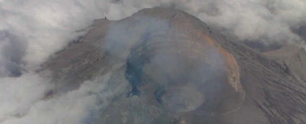
Image credit: New lava dome inside Popocatepetl's crater. Copyright: CENAPRED
Mexican CENAPRED counted 544 small to moderate emissions at Popocatepetl volcano during 24 hours between February 25 – 26, 2014.
An overflight made yesterday afternoon showed that the dome number 48 was destroyed by this activity leaving a funnel-shaped cavity about 80 meters deep. In the bottom of this, there is a new dome with a diameter of 20 to 30 meters (image below):

Overflight on February 26th showed new lava dome inside the crater. Image credit: CENAPRED, Mexico
The elevated activity was preceded by volcano-tectonic earthquakes of magnitude 2.6 and 1.6 yesterday and the day before.
A plume of steam and gas was observed moving east-southeast:

Image credit: CENAPRED
The volcano's alert level remains unchanged at "Yellow phase 2".
Explosive activity of low to intermediate level is possible as well as showers of mild to moderate ash in nearby towns. There is a chance of pyroclastic flows and short-range mudflows, CENAPRED warns.
Safety radius of 12 km around the volcano is in effect – staying in that area is not permitted.
People are advised to follow official information: CENAPRED

Teo Blašković founded The Watchers in 2011 and edited it until 2026, covering seismic and volcanic activity, extreme weather, space weather and near-Earth objects. Articles on this page are his archive.
Earlier reporting
Nothing on Watchers was published in the last 24 hours. These are older articles.
- On October 22, 2017, a single flash of lightning stretched 515 miles from eastern Texas to near Kansas City, a distance that takes eight hours to drive, and nobody realized how far it had gone until scientists went back through the satellite data years later Epicenter
- CPC posts a slight risk of heavy rain from the Gulf Coast to the Northeast urban corridor November 25-29, and a moderate risk of West Coast wind and Sierra snow on November 25
- Florida's east coast faces a moderate flash flood risk Wednesday through Friday, with 4 to 8 inches of rain forecast and the St. Johns River near Cocoa already in major flood at 17.13 feet
- Cyclone Akvan to make landfall between Nellore and Visakhapatnam around noon on November 20, IMD forecasts 120-130 km/h winds gusting to 145
