
Hydrothermal unrest persists at El Chichón volcano, Mexico
Hydrothermal unrest at El Chichón volcano in northern Chiapas, Mexico, has persisted since mid-2025, characterized by elevated seismicity, chemical-physical changes in the crater lake, and increased gas emissions. National and academic monitoring institutions report no evidence of magma ascent, and current conditions do not indicate an imminent eruption. The volcano remains at Yellow Alert.
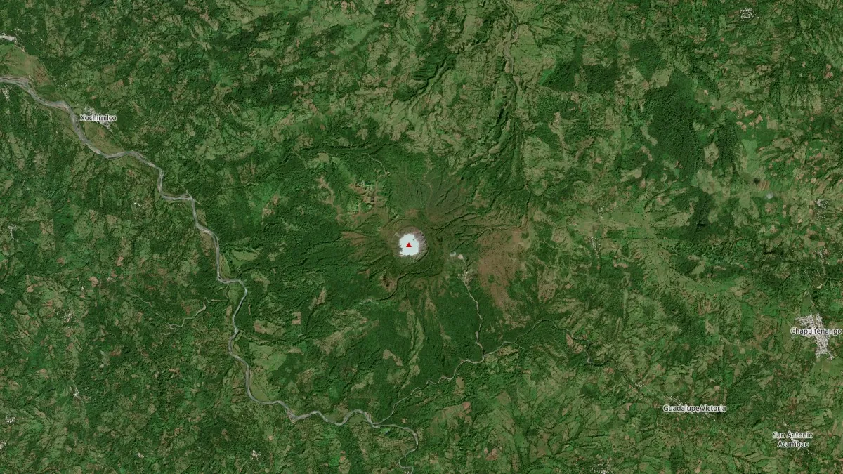
Satellite image of El Chichon volcano, Mexico on February 3, 2026. Credit: CopernicusEU/Sentinel-2, The Watchers
Hydrothermal unrest has been ongoing at El Chichón volcano in northern Chiapas since mid-2025, based on seismic, thermal, geochemical, and visual observations collected by national and academic monitoring institutions.
The activity at the volcano is characterized by shallow seismic swarms, physical-chemical changes within the summit crater lake, and persistent gas emissions, without indicators of magma migration toward the surface.
Seismicity increased during mid-2025, with numerous low-magnitude earthquakes recorded beneath and around the volcanic edifice. The events were predominantly shallow and are interpreted as reflecting fluid movement and pressurization within the hydrothermal system rather than magmatic intrusion.
Seismic unrest has continued into early 2026 at fluctuating but persistent levels, consistent with an active but non-eruptive state.
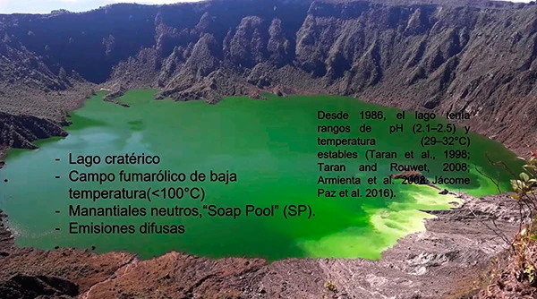
The summit crater hosts an acidic hydrothermal lake formed after the 1982 eruption. According to the National Autonomous University of Mexico (UNAM) Institute of Geophysics, the lake is approximately 1 km (0.62 miles) in diameter and 200 m (656 feet) deep, with sulfur-rich waters that reach temperatures close to 100°C (212°F).
Long-term sampling conducted over the past two decades shows recent changes in solute flux patterns throughout the hydrothermal system.
UNAM researcher Patricia Jácome Paz reported that gas bubbling through a pool of liquid sulfur at the bottom of the lake produces hollow spheres of native sulfur that briefly float to the surface before rupturing. Measurements indicate that this liquid sulfur pool reaches temperatures of up to 118°C (244°F), providing direct evidence of intensified hydrothermal circulation beneath the crater.
In recent years, the lake has also undergone pronounced changes in coloration, shifting from algae-dominated conditions to waters enriched in sulfates and silica — characteristics identified by UNAM as diagnostic of an active volcanic lake.
Significant gas emissions from the lake bottom to the surface have been documented and are recognized as a localized health hazard, particularly given continued tourist presence despite official warnings.
Following a joint assessment in August 2025, authorities reported that the volcano shows signs consistent with a modification of the hydrothermal system, with possible volcanic processes in evolution.
As a result, monitoring has been reinforced, including seismic, deformation, geochemical, thermal, and visual instrumentation. Access to the interior of the crater has been restricted to accredited researchers equipped for hazardous conditions.
The volcano remains under the Mexican Semáforo Volcánico Amarillo, Fase 1–2 — elevated but non-eruptive activity.
El Chichón is located in the municipality of Chapultenango, near the boundaries with Pichucalco, Ixtacomitán, Ostuacán, Sunuapa, and Francisco León, an area affected by both volcanic and regional tectonic structures.
Civil protection authorities in Chiapas continue community engagement activities and preparedness planning, including the development of an updated Special Civil Protection Program for the volcano, which had last been revised in 2021.
This is a trachyandesitic tuff cone and lava dome complex that has produced more than ten large explosive eruptions since the mid-Holocene. The 1982 VEI 5 eruption, one of the largest of the 20th century, destroyed the summit lava dome and generated pyroclastic flows and surges that devastated areas up to 8 km (5 miles) from the volcano, leaving a 1 km (0.6 miles) wide and 300 m (980 feet) deep crater now occupied by the hydrothermal lake.
The current unrest is fundamentally different from the 1982 eruptive sequence. Observations lack the deformation, deep seismicity, and magmatic gas signatures typically associated with magma ascent — present hazards are confined to localized phenomena, including toxic gas exposure and potential phreatic explosions near the crater.
Despite consistent scientific messaging, online speculation and some media narratives have framed the ongoing unrest as a precursor to catastrophic eruption scenarios, often drawing direct parallels to 1982 without distinguishing between magmatic and hydrothermal processes.
Monitoring agencies continue to stress that, while vigilance and restricted access are warranted, available data do not support large-scale eruptive scenarios at this time.
References:
1 Alta actividad del volcán Chichón demanda mayor monitoreo – UNAM/DGCS – January 21, 2026
2 El Chichon geological summary – GVP – Accessed February 10, 2026
I'm a dedicated researcher, journalist, and editor at The Watchers. With over 20 years of experience in the media industry, I specialize in hard science news, focusing on extreme weather, seismic and volcanic activity, space weather, and astronomy, including near-Earth objects and planetary defense strategies. You can reach me at teo /at/ watchers.news.
Commenting rules and guidelines
We value the thoughts and opinions of our readers and welcome healthy discussions on our website. In order to maintain a respectful and positive community, we ask that all commenters follow these rules.