
Tropical Storm Flossie heading toward Hawaii

Featured image: GOES West Infrared satellite image acquired at 00:30 UTC on July 27, 2013 (Credit: NOAA/GOES/CIMSS)
Tropical system developed on July 25, 2013 in East Pacific gained more strength on its track toward Hawaii. Tropical Storm Flossie is now tracking west-northwestward towards the Hawaii and should reach the islands coast by the next two or three days. The storm should gradually turn to the west in 24-48 hours as the ridge strengthens somewhat.
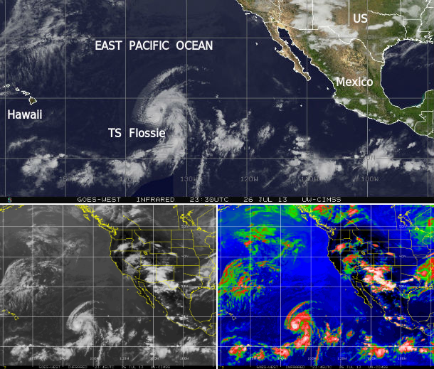
GOES West Infrared satellite iimagery composite – July 26/27, 2013 (Credit: NOAA/GOES/CIMSS)
According to latest public advisory (#8) issued by US National Hurricane Center (NHC), the center of Tropical Storm Flossie was located about 1395 miles (2245 km) E of Hilo, Hawaii. The system is moving west-northwestward at speed of 20 mph (32 km/h). Maximum sustained winds are 60 mph (95 km/h) with higher gusts.
Tropical storm force winds extended outward up to 70 miles (110 km) from the center. The estimated minimum central pressure is 999 mb (29.50 inches).
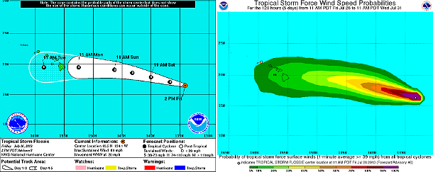
NHC forecast track and tropical force storm wind speed probability map (Credit: NOAA/NHC)
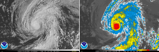
GOES West satellite imagery acquired at 01:30 UTC on July 27, 2013 – visible and AVN Infrared satellite imagery (Credit: NOAA/GOES)
A gradual weakening of Flossie should commence in the next 24 hours as it moves over cooler waters, into drier air aloft and light to moderate wind shear. The system is expected to dissipate west of the Hawaiian islands after the next five to six days due to strong southwesterly shear. Flossie is expected weaken to a tropical rainstorm by July 30, 2013. However, strong surfs, heavy downpours and lightning activity is still expected.
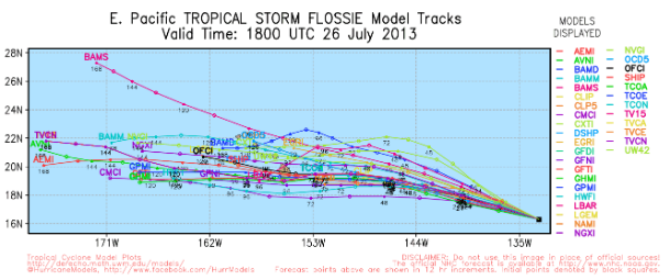
TS Flossie forecast track models (Credit: UWM/Spaghetti)
Satellite Animations
- Storm-Centered Infrared (GOES 15; NOAA/SSD)
- Storm-Centered Infrared (Aviation Color Enhancement) (GOES 15; NOAA/SSD)
- Storm-Centered Water Vapor (GOES 15; NOAA/SSD)
- Storm-Centered Visible (GOES 15; NOAA/SSD)
- Storm-Centered Visible (Colorized) (GOES 15; NOAA/SSD)
- Tropical East Pacific Hurricane Sector Infrared (GOES 15; NOAA)
- Tropical East Pacific Hurricane Sector Water Vapor (GOES 15; NOAA)
- Tropical East Pacific Hurricane Sector Visible (GOES 15; NOAA)
Commenting rules and guidelines
We value the thoughts and opinions of our readers and welcome healthy discussions on our website. In order to maintain a respectful and positive community, we ask that all commenters follow these rules.