
Powerful Hurricane “Douglas” entering the Central Pacific, heading toward Hawaii
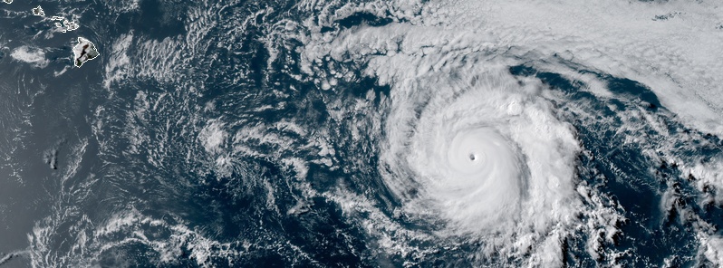
Featured image: Hurricane "Douglas" at 01:30 UTC on July 24, 2020. Credit: NOAA/GOES-West, RAMMB/CIRA
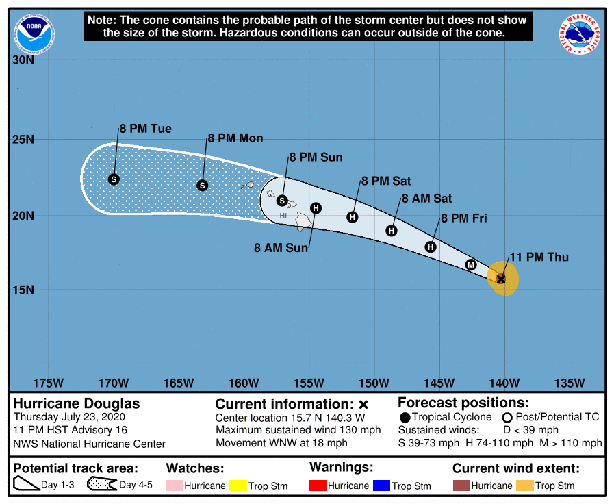
Category 4 Hurricane "Douglas" is entering the Central Pacific on its way toward Hawaii. There are still no coastal watches or warnings in effect, but interests in the Hawaiian Islands should monitor its progress as watches could be issued on Friday, July 24 for a portion of the area.
Douglas is expected to move near or over portions of the Hawaiian Islands this weekend, and there is an increasing chance that strong winds, dangerous surf, and heavy rainfall could affect portions of the state beginning Saturday night, July 25 or Sunday, July 26.
At 09:00 UTC on July 24, 2020 (23:00 HST on July 23), the center of Hurricane "Douglas" was located 1 630 km (1 010 miles) ESE of Hilo, Hawaii. Its maximum sustained winds were 215 km/h (130 mph) and the system was moving WNW at 30 km/h (18 mph). Its minimum central pressure was 954 hPa.
This motion is expected to continue for the next few days with a gradual decrease in forward speed and a slight turn toward the west.
Hurricane-force winds extend outward up to 45 km (30 miles) from the center and tropical-storm-force winds extend outward up to 150 km (90 miles).
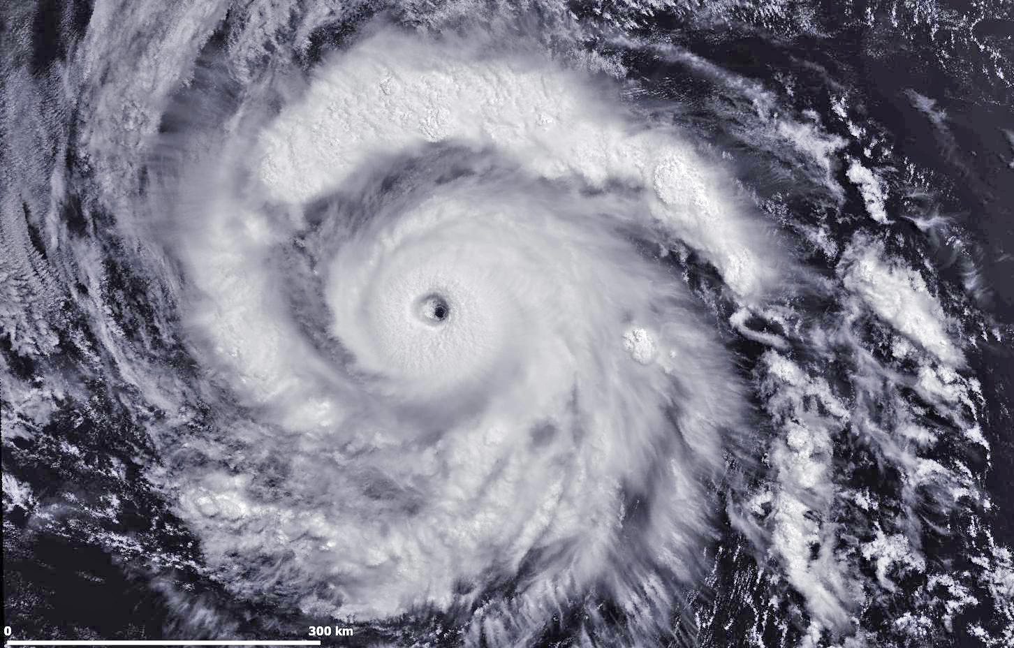
Hurricane "Douglas" at 18:45 UTC on July 24, 2020. Credit: Copernicus EU/Sentinel-3. Processed by Antonio Vecoli

Hurricane "Douglas" at 18:45 UTC on July 24, 2020. Credit: Copernicus EU/Sentinel-3. Processed by Antonio Vecoli
On the forecast track, Douglas will approach the Hawaiian Islands Saturday night, July 25 (LT), and be near those Islands on Sunday.
Gradual weakening is expected to begin on Friday, July 24, and continue through the weekend. It is forecast to be near hurricane strength when it approaches the Hawaiian islands.
Swells generated by Douglas are expected to begin affecting portions of the Hawaiian Islands on Saturday. These swells are likely to cause life-threatening surf and rip current conditions.
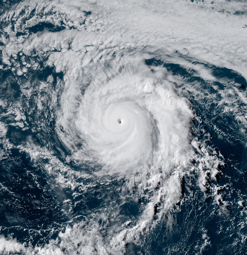
Hurricane "Douglas" at 01:30 UTC on July 24, 2020. Credit: NOAA/GOES-West, RAMMB/CIRA
"Douglas is crossing the 26 °C isotherm, and will continue to move over relatively cooler waters of about 25 °C over the next day or so," NHC forecaster Latto noted. "This should cause the cyclone to begin weakening very soon."
"In about 48 hours, Douglas is forecast to move back across the 26 °C isotherm, but at the same time the cyclone is forecast to begin encountering a drier, more stable airmass and increasing vertical wind shear. Despite the warmer waters, these other more hostile environmental factors are expected to cause Douglas to gradually weaken for the remainder of the 5-day forecast period."
I'm a dedicated researcher, journalist, and editor at The Watchers. With over 20 years of experience in the media industry, I specialize in hard science news, focusing on extreme weather, seismic and volcanic activity, space weather, and astronomy, including near-Earth objects and planetary defense strategies. You can reach me at teo /at/ watchers.news.
Commenting rules and guidelines
We value the thoughts and opinions of our readers and welcome healthy discussions on our website. In order to maintain a respectful and positive community, we ask that all commenters follow these rules.