
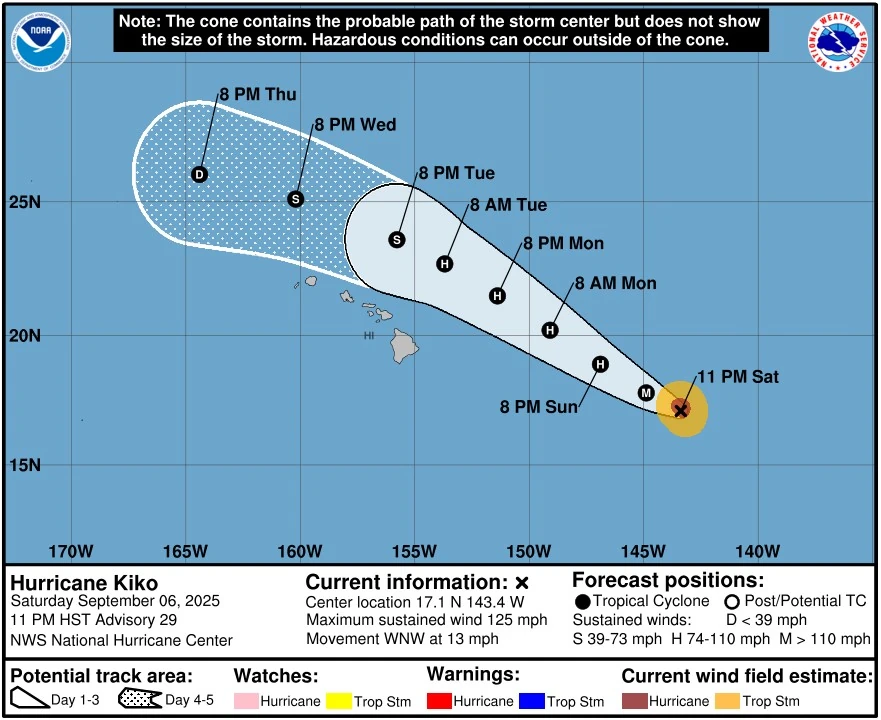
Hurricane Kiko forecast to pass north of Hawaii between September 9 and 11, hazardous surf expected
Hurricane Kiko remains a Category 3 system in the central Pacific, forecast to pass north of Hawaii early next week while generating hazardous surf and rip currents from Sunday onward. A statewide State of Emergency was declared on September 5 to prepare for potential impacts.
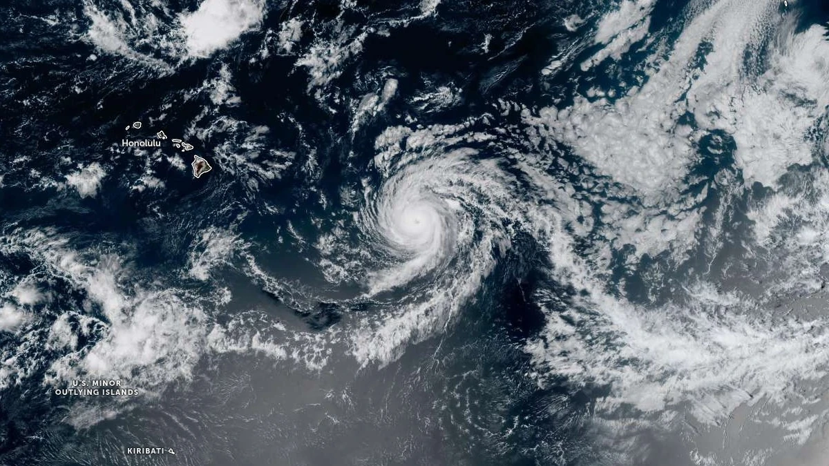
Hurricane Kiko satellite image acquired at 22:40 UTC on September 6, 2025. Credit: NOAA/GOES-West, Zoom Earth, The Watchers
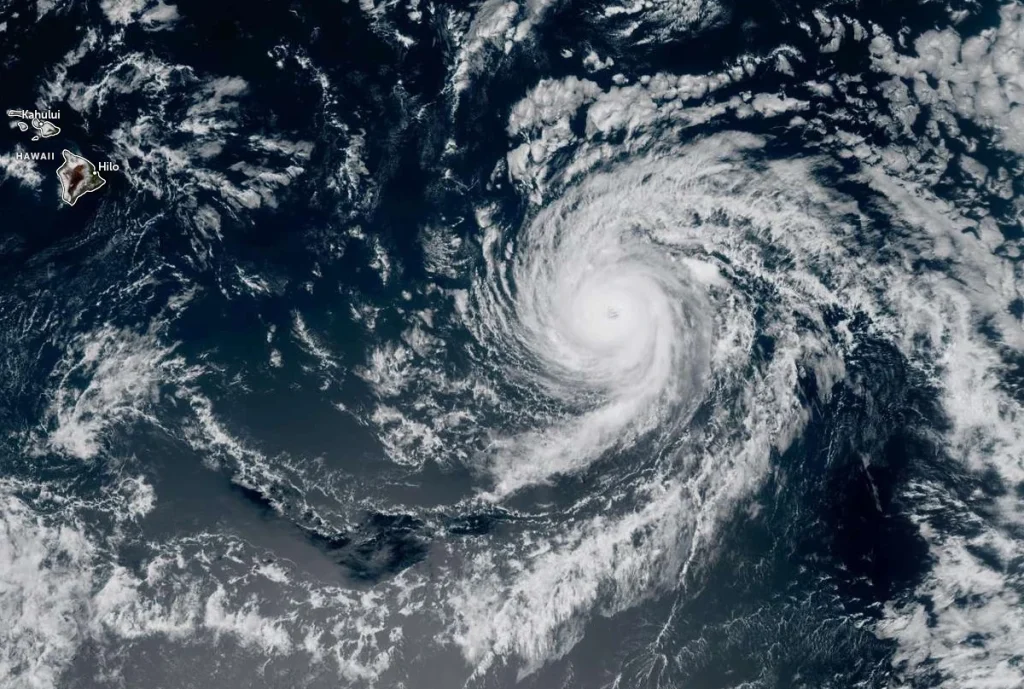
At 09:00 UTC on September 7, (23:00 HST on September 6), the center of Hurricane Kiko was located near approximately 1 265 km (785 miles) east of Hilo, Hawaii. The cyclone was moving west-northwest at 20 km/h (13 mph) with maximum sustained winds of 205 km/h (125 mph) and a minimum central pressure of 960 mb, based on data from an Air Force Reserve Hurricane Hunter aircraft.
Although Kiko has weakened from Category 4 to Category 3 intensity, it continues to exhibit an annular structure with a well-defined eye.
Forecast models indicate continued gradual weakening over cooler waters, with increasing mid-level dry air and southwesterly wind shear contributing to a more pronounced decay from Monday , September 8 through midweek. Kiko is expected to become a shallow, sheared system as it passes north of the Hawaiian Islands between September 9 and 11.
Swells generated by the hurricane are expected to reach the Big Island and Maui beginning Sunday, September 7, gradually increasing through midweek. The highest surf is forecast along east-facing shores, with life-threatening rip currents and wave conditions likely during peak swell periods.
In anticipation of these hazards, Acting Governor Sylvia Luke issued an emergency proclamation at 13:10 HST on September 5, declaring a statewide State of Emergency. The disaster emergency relief period began immediately and is set to continue through September 19 unless extended or terminated earlier.
The proclamation authorizes the activation of emergency measures and state resources, including the Hawaiʻi National Guard and the Major Disaster Fund. It temporarily suspends certain state laws related to procurement, public works, and environmental regulations to expedite emergency response and recovery efforts.
According to the statement, tropical storm-force winds, heavy rainfall, and high surf could begin affecting parts of the state as early as Monday, September 8.
“To ensure the safety and preparedness of our communities, the state and counties will stand ready to mobilize resources to clear debris, secure infrastructure, and respond quickly to any possible damage caused by the storm,” said Acting Governor Luke.
At the time of the latest advisory, hurricane-force winds extended outward up to 55 km (35 miles) from the center, with tropical-storm-force winds reaching up to 130 km (80 miles). No watches or warnings are currently in effect, but the National Weather Service continues to monitor the system and urges the public to stay informed and follow all official guidance.
Another reconnaissance mission by the Hurricane Hunter aircraft is scheduled for 18:00 UTC on September 7 to provide updated data on intensity and structure.
References:
1 Hurricane Kiko Advisory Number 29 – NHC/CPHC – September 7, 2025
2 Hurricane Kiko Discussion Number 29 – NHC/CPHC – September 7, 2025
3 Office of the Governor – News release – Emergency proclamation issued ahead of Hurricane Kiko – Governor of Hawai‘i – September 5, 2025

I am an Assistant Editor and Severe Weather & Science Journalist at The Watchers, specializing in real-time severe weather coverage, geophysical event reporting, and research-driven scientific analysis. You can reach me at rishav(at)watchers(.)news.
Commenting rules and guidelines
We value the thoughts and opinions of our readers and welcome healthy discussions on our website. In order to maintain a respectful and positive community, we ask that all commenters follow these rules.