
Hurricane “Douglas” tracks away from Hawaii after passing just north of Oahu
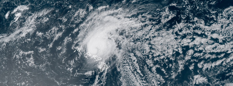
Image credit: NOAA/GOES-West, RAMMB/CIRA. Acquired 01:50 UTC on July 27, 2020.
The eyewall of Hurricane "Douglas" passed just north of Oahu on Sunday night (LT), July 26, 2020, sparing Hawaii of the storm's worst. At 15:00 UTC (05:00 LT) on Monday, July 27, the center of the storm was located about 149 km (90 miles) northwest of Lihue, moving west-northwest near 27 km/h (17 mph).
Douglas approached Hawaii with maximum sustained winds of 150 km/h (90 mph) and minimum central pressure of 987 hPa. Hurricane-force winds extended outward up to 45 km (30 miles) from its center and tropical-storm-force up to 165 km (105 miles).
"It just scraped the islands of Hawaii, they are so lucky they didn't get the worst of the rain and the wind and the storm surge," said Fox News senior meteorologist, Janice Dean.
Governor David Ige told Honolulu Star that they were "fortunate in that we did not have major flooding or major dislocations," adding that he was generally pleased with how the state responded to the storm's threats.
Residents prepared for the risks of damaging wind, rain, and high surf following warnings by the state and county officials. A siren alerted citizens of Oahu as the hurricane went near the isle.
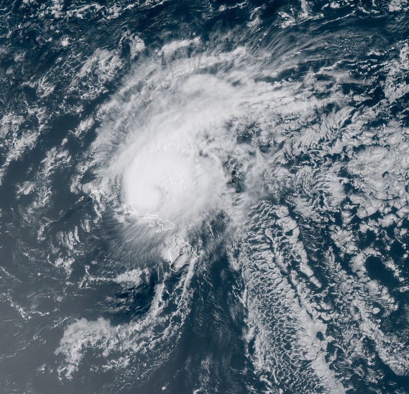
Hurricane "Douglas" at 01:50 UTC on July 27, 2020. Credit: NOAA/GOES-East, RAMMB/CIRA
"I do think people responded and were prepared," Ige remarked. "I saw a lot of people taking the appropriate preparations."
No major damage was reported as Douglas passed north of Hawaii island and drenched Maui Sunday morning.
Here's another look at #Hawaii's close call with Hurricane #Douglas via storm-centered Morphed Integrated Microwave Imagery at CIMSS (MIMIC-TC). More #HIwx #HurricaneDouglas info & imagery at https://t.co/xDmCoovIjo pic.twitter.com/TDLZn8kOBt
— UW-Madison CIMSS (@UWCIMSS) July 27, 2020
Hurricane #Douglas came this close to slamming into Hawaii
40 miles made all the difference pic.twitter.com/tutuQuQp8l
— Greg Diamond (@gdimeweather) July 27, 2020
4:30 AM HST JUL 27 2020
…& There IT Is…
#COVIDHurricaneDouglas#HurricaneDouglas Clears ALL 8 Main Hawaiian Islands: #Hawaii, #Maui, #Kahoolawe, #Lanai, #Molokai, #Oahu, #Kauai, & #Niihau! via UW-Madison CIMSS @UWCIMSS
The'ALL CLEAR' Is Given! …Aloha!#HIWx pic.twitter.com/heZkfN83uB
— The View Master! (@AlohaEvery1) July 27, 2020
A radar view of Hurricane Douglas tracking just north of Hawaii during this past weekend. Thanks to @BMcNoldy for creating these radar animations. pic.twitter.com/wMwXWZnnnr
— NWS Eastern Region (@NWSEastern) July 27, 2020
Meanwhile, the National Weather Service (NWS) issued a high surf advisory early Monday morning, July 27, for east-facing shores of Oahu and Kauai.
The agency warned of "residual swell energy from Hurricane Douglas, combined with strengthening trade winds," which is expected to maintain elevated, rough surf along east facing shores of the said islands.
"Expect strong breaking waves, shore break, and strong longshore and rip currents making swimming difficult and dangerous," NWS wrote.
As Douglas leaves the north Hawaii area, trade winds are forecast to return and gradually strengthen through Monday. The winds are being supplied by a broad surface high located far north of the area.
At around 15:00 UTC (05:00 LT) on Monday, the center of Douglas was located 149 km (90 miles) northwest of Lihue, moving west-northwest near 27 km/h (17 mph), and this general motion will continue for the next couple of days with a slight turn toward the west.
Its maximum sustained winds were 150 km/h (90 mph) and minimum central pressure 987 hPa.
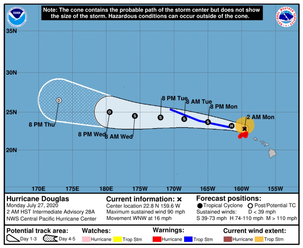
Image credit: NHC
Commenting rules and guidelines
We value the thoughts and opinions of our readers and welcome healthy discussions on our website. In order to maintain a respectful and positive community, we ask that all commenters follow these rules.