
Tropical Storm Hagupit moves through Yap State, expected to enter PAR as Caloy
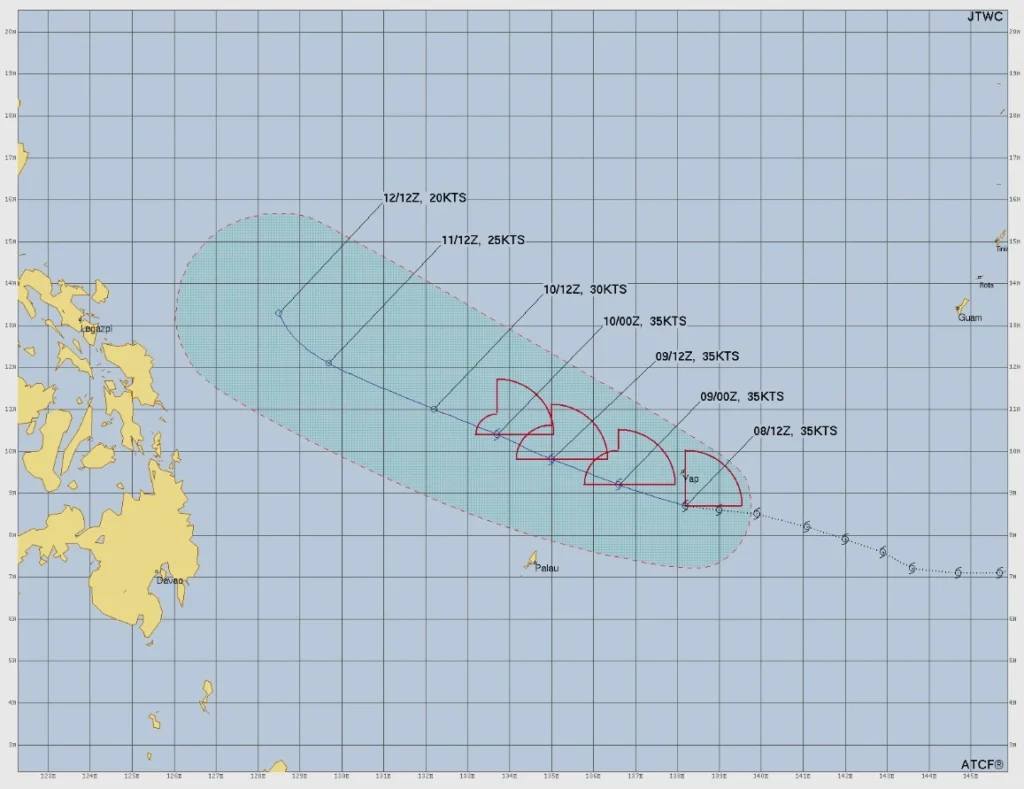
Tropical Storm Hagupit was moving west through Yap State at 22:00 ChST (12:00 UTC) on May 8, 2026, with maximum sustained winds of 70 km/h (45 mph). Tropical Storm Warnings remained in effect for Ulithi, Ngulu, Fais, Yap Proper, and adjacent coastal waters. PAGASA expects the system to enter the Philippine Area of Responsibility on May 9 and be named Caloy.
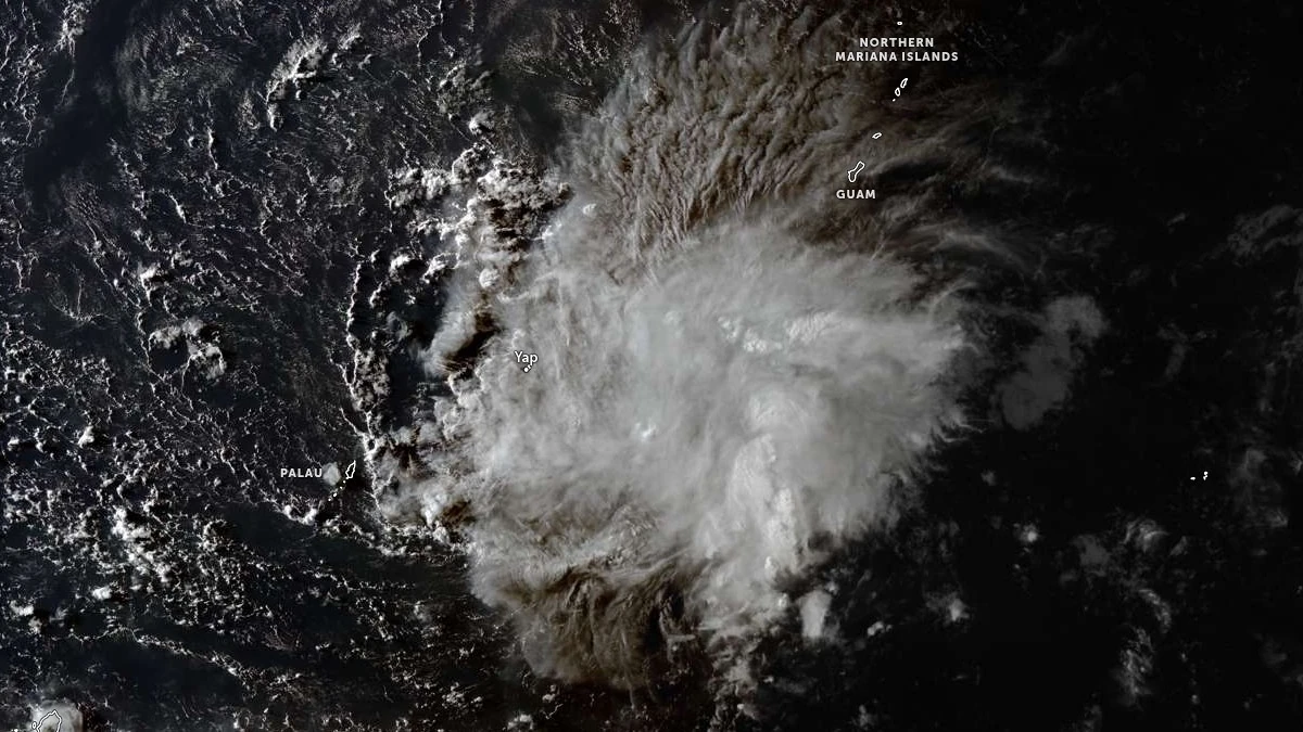
Satellite image of Tropical Storm Hagupit acquired at 08:10 UTC on May 8, 2026. Credit: JMA/Himawari-9, Zoom Earth, The Watchers
The National Weather Service (NWS) office in Guam placed the center of Tropical Storm Hagupit about 90 km (55 miles) south of Yap, 90 km (55 miles) east-northeast of Ngulu, 225 km (140 miles) southwest of Ulithi, and 645 km (400 miles) west-northwest of Woleai at 12:00 UTC today.
Hagupit was moving west at 19 km/h (12 mph), with tropical-storm-force winds extending up to 145 km (90 miles) north of the center.
A Tropical Storm Warning remains in effect for Ulithi, Ngulu, Fais in Yap State, and Yap Proper and adjacent coastal waters. Tropical storm conditions, including winds of 65-115 km/h (40-75 mph), are expected within 24 hours.
Hagupit was departing Fais and Ulithi while approaching Yap Proper and Ngulu, with tropical-storm-force winds occurring or imminent for Ngulu and Yap Proper through at least Saturday morning.
For Yap and Ngulu, the forecast called for tropical-storm-force winds of 55-70 km/h (35-45 mph), increasing to about 80 km/h (50 mph) from the north to northeast as Hagupit passed over or just south of Yap Proper. Tropical-storm-force winds were forecast to leave Yap and Ngulu on Saturday morning or early afternoon as the storm moved farther west-northwest.
Rainfall near the center was forecast at 200-300 mm (8-12 inches), with locally higher amounts that may produce localized flooding. Seas of 3-4.5 m (10-15 feet) were expected to develop quickly, while hazardous surf, minor coastal inundation, and beach erosion were forecast along exposed coasts. Surf could reach 4.5 m (15 feet) or more.
Ulithi and Fais were forecast to receive additional rainfall of 75-150 mm (3-6 inches) and 125–230 mm (5-9 inches), respectively. Tropical-storm-force winds of 55-70 km/h (35-45 mph), with gusts to 95 km/h (60 mph), were expected to diminish there as Hagupit moved farther west.
NWS Guam advised people under warnings to complete preparations, move to adequate shelter where locations are vulnerable to tropical storm conditions, follow local officials, and return small craft to port or safe harbor. The agency advised residents not to focus on the exact forecast track.
The Yap Department of Education closed all public and private schools on Friday, May 8.
PAGASA’s weekly outlook, issued at 12:00 PHT on May 8, said Hagupit was expected to enter the Philippine Area of Responsibility (PAR) between Saturday afternoon and evening, May 9. The agency forecast cloudy skies with scattered rains and thunderstorms over Eastern Visayas, Surigao del Norte, Dinagat Islands, Catanduanes, and Sorsogon from May 11 to 12.
PAGASA expected Caloy to weaken into a low pressure area on Wednesday, May 13, while still bringing cloudy skies with scattered rains and thunderstorms over Catanduanes, Northern Samar, and Eastern Samar. Metro Manila and the rest of the Philippines were forecast to experience partly cloudy to cloudy skies with isolated rain showers or thunderstorms.
Hagupit is 5th named storm of the 2026 Pacific typhoon season, following tropical storms Noaken in January, Penha in February, Nuri in March, and Super Typhoon Sinlaku in April.
References:
1 Tropical Storm Hagupit (05W) Intermediate Advisory Number 11A – NWS/Guam – 10:55 ChST on May 8, 2026
2 Tropical Storm Hagupit continues to move WNW through Yap State – NWS/Tiyan – 20:54 ChST on May 8, 2026
3 Tropical Storm 05W (Hagupit) Warning #12 – JTWC – 15:00 UTC on May 8, 2026
I'm a dedicated researcher, journalist, and editor at The Watchers. With over 20 years of experience in the media industry, I specialize in hard science news, focusing on extreme weather, seismic and volcanic activity, space weather, and astronomy, including near-Earth objects and planetary defense strategies. You can reach me at teo /at/ watchers.news.
Commenting rules and guidelines
We value the thoughts and opinions of our readers and welcome healthy discussions on our website. In order to maintain a respectful and positive community, we ask that all commenters follow these rules.