
Douglas becomes a major hurricane on its way toward Hawaii
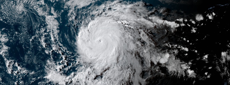
Featured image: Hurricane "Douglas" at 02:00 UTC on July 23, 2020. Credit: NOAA/GOES-West, RAMMB/CIRA
Tropical Storm "Douglas" became the first hurricane of the 2020 eastern Pacific hurricane season at 15:00 UTC on July 22, 2020, and then rapidly strengthened into a major hurricane by 09:00 UTC on July 23. The only years with later first eastern North Pacific hurricane formations in the satellite era are 1987 (July 24), 1968 (August 8), and 2003 (August 24), according to Dr. Philip Klotzbach.
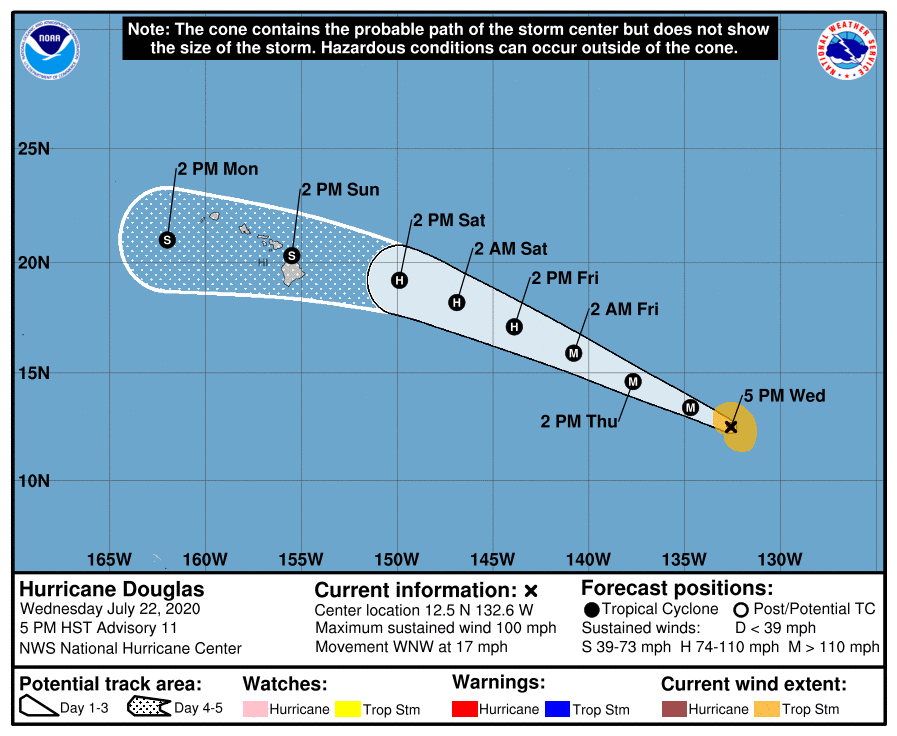
- Douglas is expected to be at or near hurricane intensity as it approaches the Hawaiian Islands on Sunday, July 26.
- The storm is expected to move near or over portions of the Hawaiian Islands this weekend, and there is an increasing chance that strong winds and heavy rainfall could affect portions of the state beginning on Sunday.
- Interests on the Hawaiian Islands should continue to monitor the progress of Douglas and the official forecasts as they evolve over the next few days.
At 09:00 UTC on July 23 (23:00 HST, July 22), the center of Hurricane "Douglas" was located 2 365 km (1 470 miles) ESE of Hilo, Hawaii. The system had maximum sustained winds of 195 km/h (120 mph) and was moving WNW at 28 km/h (17 mph), according to the NWS. Its minimum central pressure was 967 hPa.
Douglas is now a category 3 hurricane on the Saffir-Simpson Hurricane Wind Scale.
Some additional strengthening is possible on Thursday but gradual weakening is forecast to begin by early Friday.
Hurricane-force winds extend outward up to 35 km (25 miles) from the center and tropical-storm-force winds extend outward up to 165 km (105 miles).
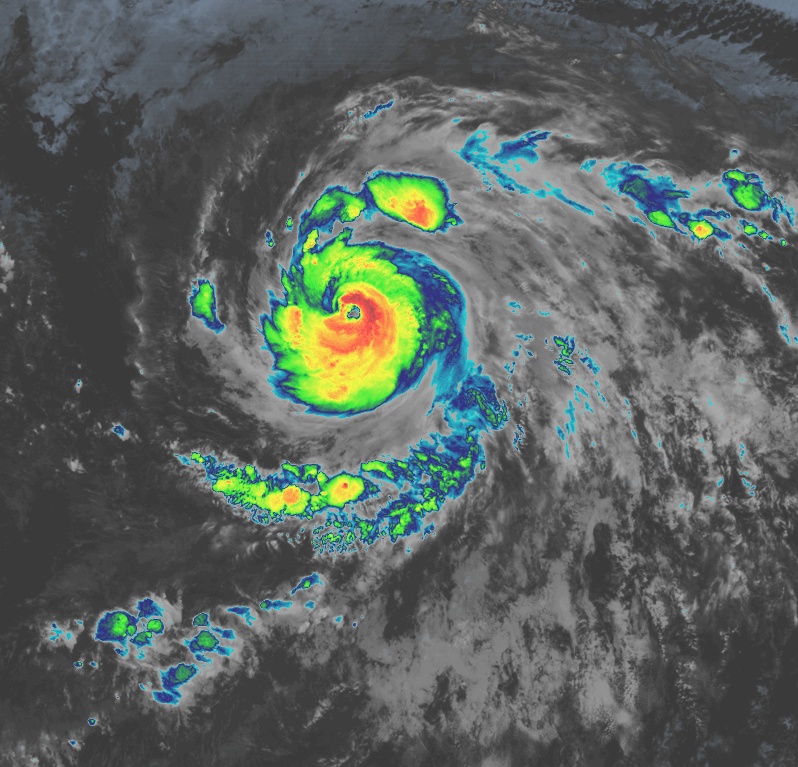
Hurricane "Douglas" at 08:00 UTC on July 23, 2020. Credit: NOAA/GOES-West, RAMMB/CIRA
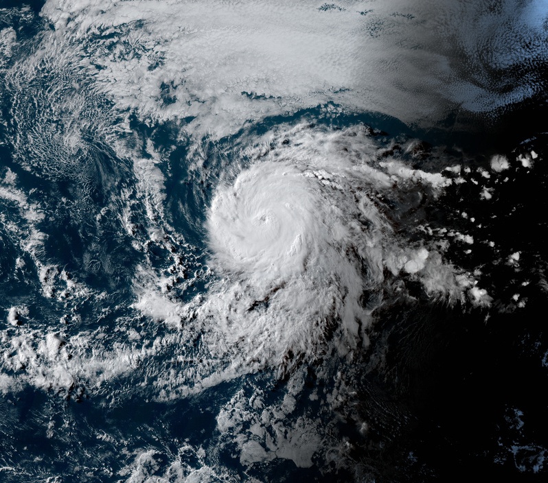
Hurricane "Douglas" at 02:00 UTC on July 23, 2020. Credit: NOAA/GOES-West, RAMMB/CIRA
Satellite images are showing a ragged, but nearly clear eye surrounded by cold cloud tops of -70 °C, NWS forecaster Latto noted.
There appears to be a little dry air intrusion across the northern portion of the circulation, which is limiting the amount of deep convection wrapping around that part of the eye.
The environmental conditions supporting the rapid intensification appear at their best at this time as the cyclone is over SSTs of over 28 °C, with low wind shear in a moist air mass.
If the cyclone can fight off the dry air in the northern semicircle, some additional strengthening is possible, especially early Thursday, Latto said.
"However, Douglas should be gradually moving into a less hospitable environment for strengthening over the next few days, and in 36 hours the cyclone is forecast to cross the 26 °C SST isotherm and into a region where the 500-700 hPa relative humidity is less than 60 percent."
Later on in the 5-day forecast period, wind shear is also expected to be on the increase.
These factors should cause the cyclone to gradually weaken beginning Thursday night.
Douglas is expected to be at or near hurricane intensity as it approaches the Hawaiian Islands on Sunday, and all interests there should monitor forecasts as they evolve over the next few days, NHC said.
I'm a dedicated researcher, journalist, and editor at The Watchers. With over 20 years of experience in the media industry, I specialize in hard science news, focusing on extreme weather, seismic and volcanic activity, space weather, and astronomy, including near-Earth objects and planetary defense strategies. You can reach me at teo /at/ watchers.news.
Commenting rules and guidelines
We value the thoughts and opinions of our readers and welcome healthy discussions on our website. In order to maintain a respectful and positive community, we ask that all commenters follow these rules.