
New eruption at Kilauea’s summit caldera, Aviation Color Code raised to Red, Hawai’i
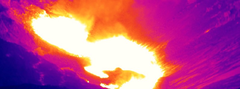
Image credit: USGS/HVO
A new eruption has started within Kīlauea’s summit caldera, Hawai'i at 07:36 UTC on December 21, 2020. Accordingly, the Hawaiian Volcano Observatory (HVO) has elevated Kīlauea's volcano alert level to WARNING and its aviation color code to RED. The situation is rapidly evolving, HVO said in a statement released at 08:41 UTC today. Civil Defense cautioned that ash fallout is likely in Wood Valley, Pahala, Naalehu and Ocean View, and advised residents and visitors to stay indoors to avoid exposure to ash. The last eruption of this volcano took place in 2018 (VEI 3).
An earthquake swarm began on the evening (LT) of December 20, accompanied by ground deformation detected by tiltmeters, HVO said.
An orange glow was subsequently observed on IR monitoring cameras glow within the Halemaʻumaʻu crater at the summit of Kīlauea Volcano, visually beginning at approximately 07:36 UTC on December 21 (21:36 HST, December 20).
"An eruption has commenced within Kīlauea’s summit caldera. The situation is rapidly evolving and HVO will issue another statement when more information is available," the observatory said.
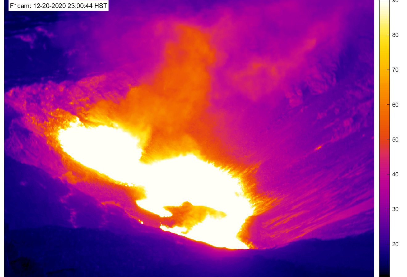
Image credit: USGS/HVO
Halemaʻumaʻu and water lake – thermal image [F1cam] – LIVE view from the west rim of the new summit collapse features. Credit: USGS/HVO
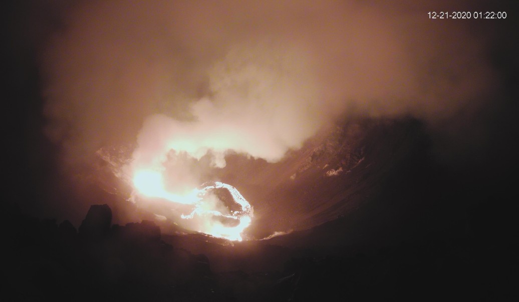
Kilauea summit at 11:22 UTC on December 21, 2020. Credit: USGS/HVO
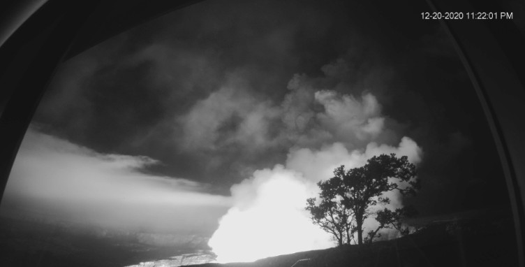
Image credit: USGS/HVO
According to the Washington VAAC, the volcanic ash cloud was observed extending 74 km (46 miles) SSW from the summit area at 09:06 UTC. "WFO reports volcanic ash cloud to 9.1 km (30 000 feet) a.s.l. on local radar."
Civil Defense cautioned that ash fallout is likely in Wood Valley, Pahala, Naalehu and Ocean View, and advised residents and visitors to stay indoors to avoid exposure to ash.
Bill Hanson of the Hawaii County Civil Defense said Civil Defense has received no reports of damage from the public. In addition, he said no damage was reported at the observatory or within the park.
Civil Defense also said a M4.4 earthquake that struck at 08:36 UTC today on Kilauea’s south flank was not large enough to cause a tsunami.
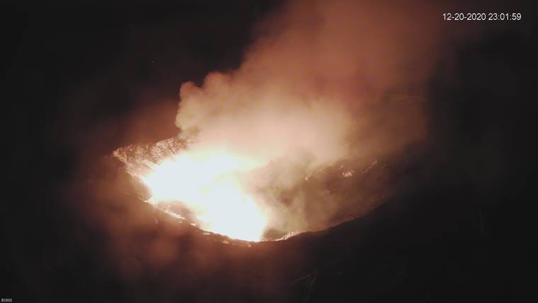
Image credit: USGS/HVO
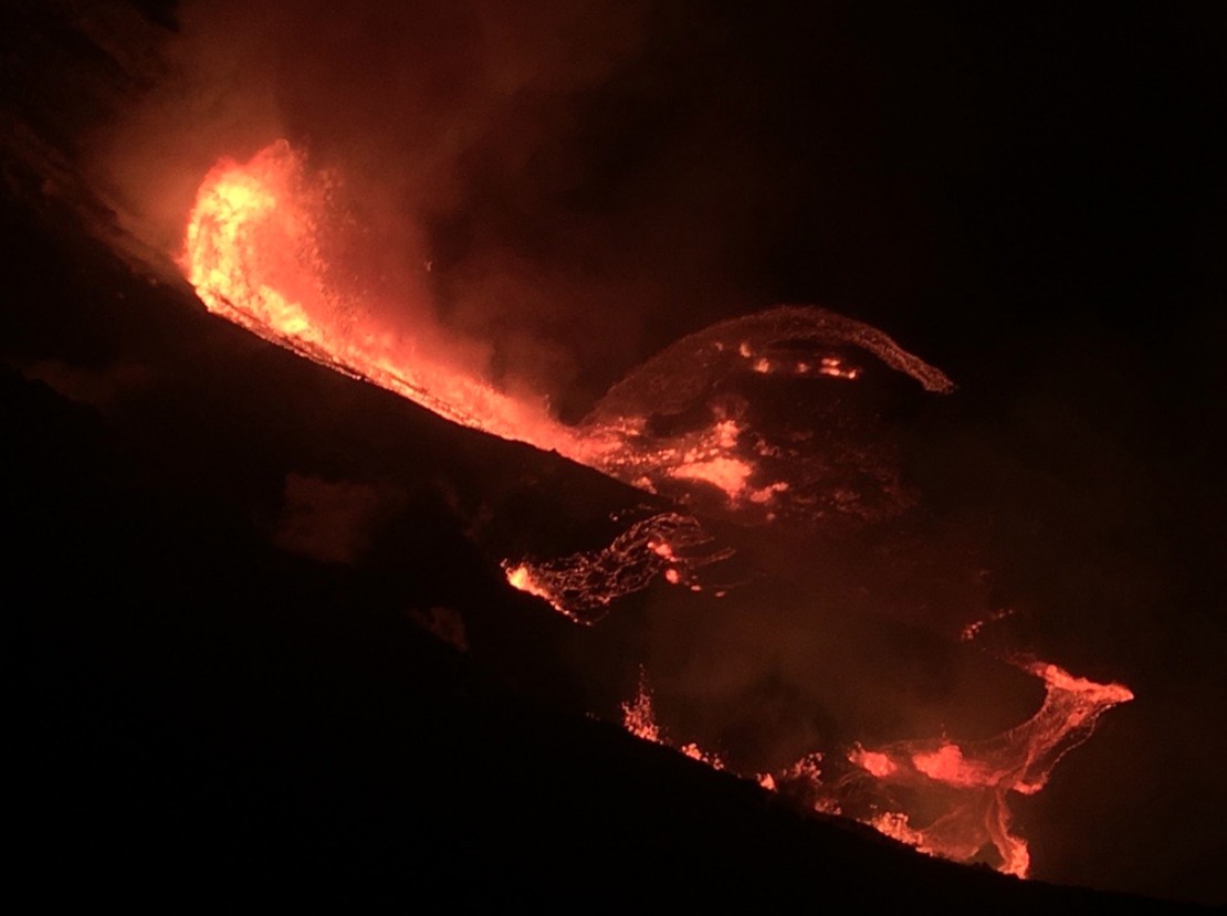
Image credit: USGS/HVO
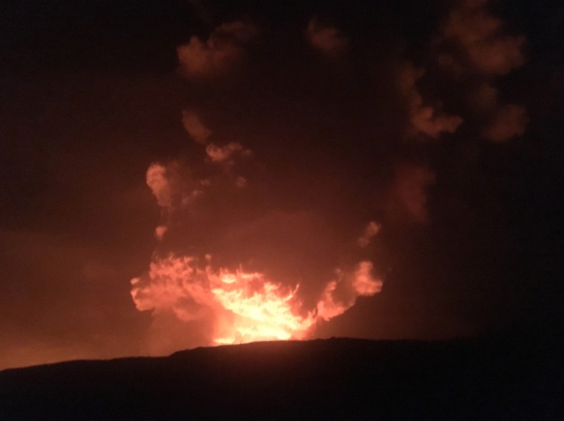
Image credit: USGS/HVO
Over the past several weeks, the observatory has recorded ground deformation and earthquake rates at Kīlauea Volcano’s summit and upper East Rift Zone that have exceeded background levels observed since the conclusion of the 2018 lower East Rift Zone eruption and summit collapse.
Beginning in September 2020, increased rates of uplift were observed by GPS stations in Kīlauea’s upper East Rift Zone.
In the past month, increased uplift has also been measured at GPS stations in Kīlauea’s summit region. While uplift related to post-collapse inflation of the summit reservoir has been occurring since March of 2019, rates have been steadily increasing in recent months and are currently higher than they have been since the end of the 2018 eruption.
In late November 2020, increased earthquake rates began when seismic stations recorded an average of at least 480 shallow, small-magnitude earthquakes (97% of which were less than or equal to magnitude-2) per week occurring at depths of less than 4 km (2.5 miles) beneath Kīlauea's summit and upper East Rift Zone. This compares to a rate of fewer than 180 per week following the end of Kīlauea’s 2018 eruption and through early November 2020.
On December 2, 2020, GPS stations and tiltmeters recorded a ground deformation event at Kīlauea’s summit.
Accompanied by earthquake swarms, the patterns of ground deformation observed were consistent with a small dike intrusion of magma under the southern part of Kīlauea caldera. The injection resulted in about 8 cm (3 inches) of uplift of the caldera floor, and modeling suggests that it represented 0.4–0.7 million cubic meters (yards) of magma accumulated approximately 1.5 km (1 mile) beneath the surface.
Though the intrusion did not reach the surface and erupt, it represented a notable excursion from trends observed in the Kīlauea summit monitoring data streams following the end of the 2018 eruption.
On December 17, 2020, seismometers detected a notable increase in occurrence and duration of long-period seismic signals beneath Kīlauea’s summit, which are attributed to magmatic activity. Whereas this type of seismicity was observed on average once every few weeks following the 2018 eruption, rates have increased to over a dozen in the past several days.
Other monitoring data streams including volcanic gas and webcam imagery were stable until this eruption, HVO said.
View from the western rim of Kīlauea Caldera. Lava is erupting from a fissure in the NW wall of Halemaʻumaʻu crater and cascading into the deepest part of the crater, which had been occupied by a water lake (now replaced with a growing lava lake). pic.twitter.com/VKIFA1Npr0
— USGS Volcanoes (@USGSVolcanoes) December 21, 2020
Video of the eruption from Jaggar Overlook at about 11:30 PM HST. pic.twitter.com/7CgZJMNn1R
— USGS Volcanoes (@USGSVolcanoes) December 21, 2020
Geological summary
Kilauea volcano, which overlaps the east flank of the massive Mauna Loa shield volcano, has been Hawaii's most active volcano during historical time.
Eruptions of Kilauea are prominent in Polynesian legends; written documentation extending back to only 1820 records frequent summit and flank lava flow eruptions that were interspersed with periods of long-term lava lake activity that lasted until 1924 at Halemaumau crater, within the summit caldera.
The 3 x 5 km (1.9 x 3.1 miles) caldera was formed in several stages about 1500 years ago and during the 18th century; eruptions have also originated from the lengthy East and SW rift zones, which extend to the sea on both sides of the volcano.
About 90% of the surface of the basaltic shield volcano is formed of lava flows less than about 1 100 years old; 70% of the volcano's surface is younger than 600 years. A long-term eruption from the East rift zone that began in 1983 has produced lava flows covering more than 100 sq km (37 sq miles), destroying nearly 200 houses and adding new coastline to the island. (GVP)
I'm a dedicated researcher, journalist, and editor at The Watchers. With over 20 years of experience in the media industry, I specialize in hard science news, focusing on extreme weather, seismic and volcanic activity, space weather, and astronomy, including near-Earth objects and planetary defense strategies. You can reach me at teo /at/ watchers.news.
In geophysics, it is well known that hotspot volcanoes, like the volcanoes of the Hawaiian Islands, Réunion, Yellowstone, Galápagos, Iceland and many others, are hotspots that are fed by narrow streams of hot mantle rising from the Earth’s core–mantle boundary in a structure called a mantle plume. In fact, currently the estimate for the number of hotspots postulated to be fed by mantle plumes has increased to several thousands, by many geologists.
Now, the question that one should ask, how can the temperature of the core of the Earth remain to be hotter than the surface of the Sun, taking into consideration that those volcanoes have been erupting for billions of years? In other words, if one takes into consideration the number of times hot spot volcanoes have erupted over the last 4.543 billion years how can the core of the Earth, remains to be hotter than the surface of the Sun? And, never mind about the rest of land volcanoes or the hundreds of thousands of submarine volcanoes.
I think conventional theories have no chance of answering this question, This question can only be answered by Al Gore-Greta Thunberg Theory. Hahahahahahahahaha
this is close to the Hilina slump region so GPS should watch for ground movement
Was up there with my niece and nephew on Friday. It rained very hard for three days before this eruption. I think that could have triggered it.
Linda , are you asking me to provide information?
beautifull
The increased volcanic activity may be partially caused by the two heavy weight planets Jupiter and Saturn in conjunction in the evening in the east and the sun set in the west creating an alignment.?
Please provide information as this worsens.
Thank you,
Linda Lee Fleming
The increase of gamma rays emission from the Sun is already having an effect on our planet, and it will intensive in the next 36-48 hours. Please keep in mind, that the gamma rays produced by the Sun is not the result of thermonuclear furnace which is supposed to be responsible for the primary energy source of the Sun. Thermonuclear reactions took place in the mystic mind of Stanley Eddington and enforced it on the scientific community with the help of other ambitious theoreticians, just like his fake solar eclipse experiment of May 29, 1919.
smoke more cannabis
When does the lava reach the ocean?