
U.S. Plains on alert for multiday severe weather including tornadoes and hail
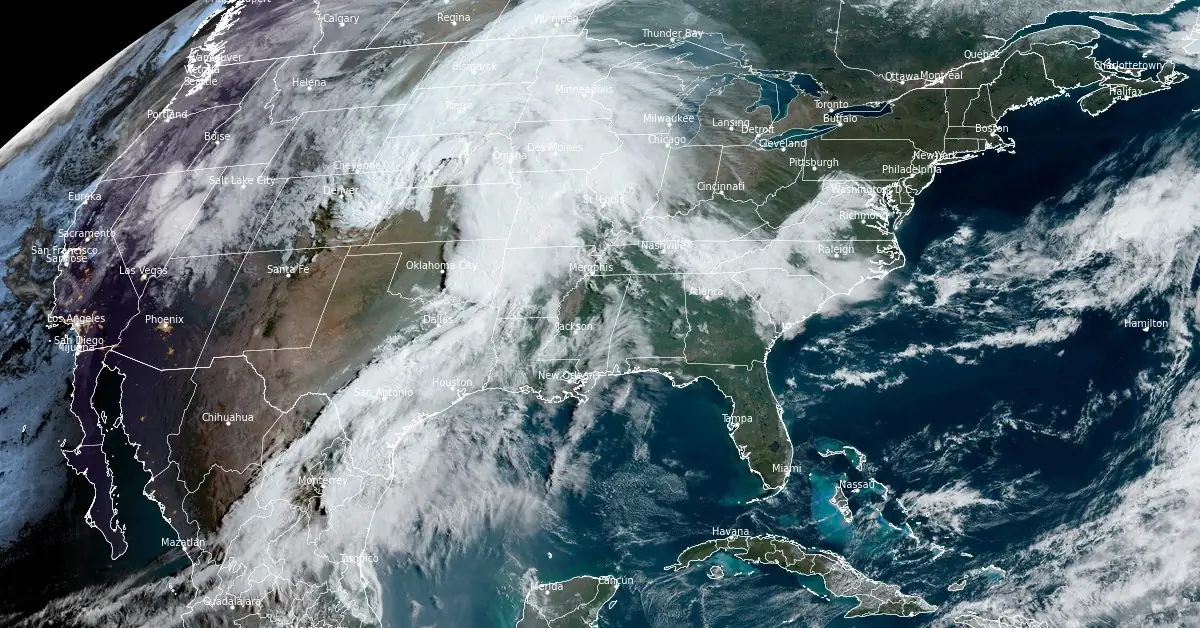
Image credit: NOAA/GOES-East, RAMMB/CIRA, The Watchers. Acquired at 13:30 UTC on April 26, 2024
A severe weather warning covers the Plains, threatening over 55 million residents with strong tornadoes, hail the size of baseballs, and damaging wind gusts. The National Weather Service has issued a Tornado Watch as the region braces for potentially destructive weather through the weekend.
A significant severe weather threat has enveloped the Plains, placing over 55 million Americans at risk. The National Weather Service (NWS) has issued a Tornado Watch and predicts a multiday severe weather event that could last through the weekend. This threat includes potentially strong tornadoes, hail larger than baseballs, and damaging wind gusts.
The severe weather began unfolding on Thursday afternoon, April 25, with the most intense storms striking eastern Colorado, western Kansas, and southern Nebraska. Approximately 70 reports of large hail, including ice chunks as big as tennis balls (6.5 cm / 2.5 inches), were recorded in these regions. Wind gusts reached as high as 115 km/h (70 mph) near Sharon Springs, Kansas.
The forecast for today, Friday, April 26, includes an Enhanced Risk (Level 3 out of 5) of severe thunderstorms in the lower Missouri River Valley, indicating the possibility of very large hail, damaging winds, and a few strong tornadoes. Additionally, a Slight Risk (Level 2 out of 5) of excessive rainfall spans from northeast Texas into central Missouri, raising concerns for flash, urban, and river flooding.
High resolution imagery of severe storms erupting tonight across the Central Plains. pic.twitter.com/S6GqdUuKba
— CIRA (@CIRA_CSU) April 26, 2024
From the High Plains to West Texas, nighttime storms continue to bring strong and severe weather across the Central US.
— CIRA (@CIRA_CSU) April 26, 2024
Large hail and some tornado reports have come from this system. pic.twitter.com/5ac8IIrqpc
Kebede, a forecaster with the National Weather Service, said the dynamic nature of the weather system, is expected to bring significant impacts across the Plains into the Mid-to-Upper Mississippi Valley regions over the weekend. Today, eastern Oklahoma and northeastern Texas into western Arkansas and southern Missouri face a Slight Risk of excessive rainfall that could lead to flash flooding.
Severe thunderstorms have already been detected on radar across the Plains and Midwest on Friday morning. The FOX Forecast Center noted that the severe weather risk extends over a 1 800 km (1 000 miles) stretch from southern Minnesota to Texas. A Tornado Watch remains in effect until 11:00 CDT for portions of eastern Oklahoma, with potential for a few tornadoes, scattered damaging wind gusts up to 115 km/h (70 mph), and isolated large hail events up to 2.5 cm (1 inch) in diameter.
The severity of the situation was highlighted by the emergency manager for Pottawatomie County, who reported a tornado early Friday morning after observing fallen trees and power lines about 6.4 km (4 miles) west of Bethel Acres.
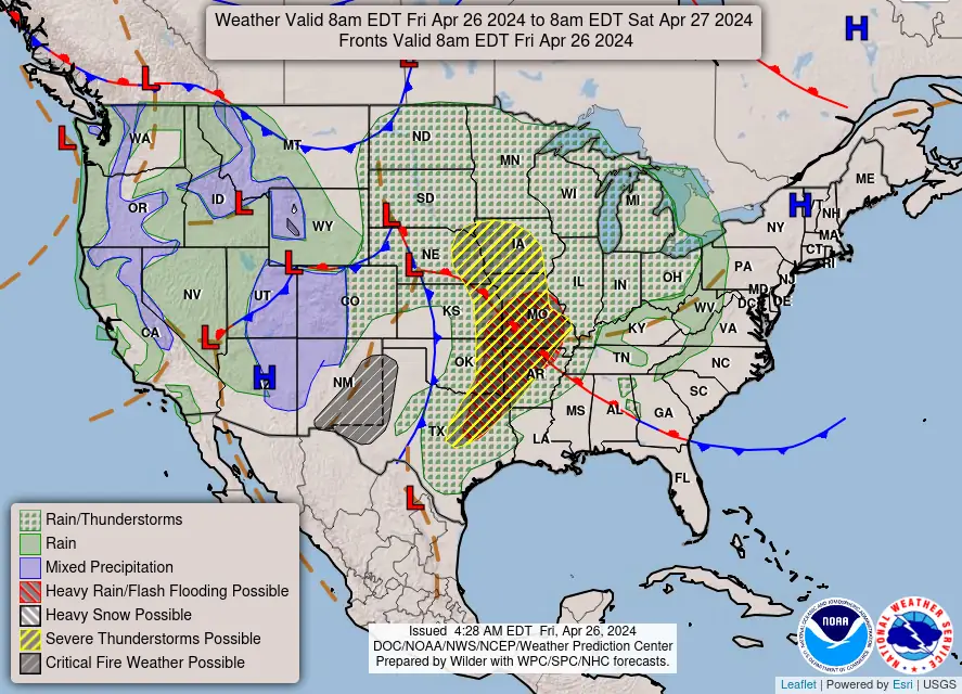
As the system progresses, severe thunderstorms are likely to affect areas of eastern Nebraska, western and central Iowa, eastern Kansas, and northwest Missouri on Friday. The Storm Prediction Center has outlined over 4.8 million people in Level 3 out of 5 severe weather threat zones, including major cities such as Overland Park, Kansas; Kansas City, Missouri; Omaha and Lincoln, Nebraska; and Des Moines, Iowa.
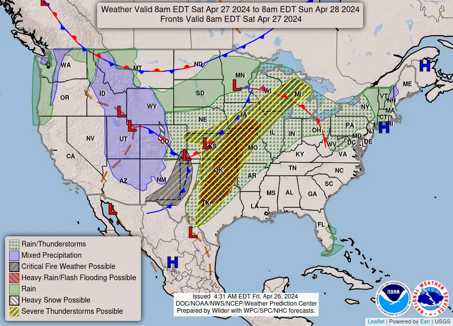
Looking ahead to Saturday, April 27, another system emerging from the Rockies is expected to refocus the potential for heavy rainfall and severe storms over the Southern Plains. This includes a Moderate Risk (at least 40%) of excessive rainfall over central to northeastern Oklahoma, with storms potentially turning severe, featuring damaging winds, large hail, and isolated tornadoes.
“The storm itself is getting a dropkick in from the West … that’s why tomorrow (Saturday) is a bigger deal,” FOX Weather Meteorologist Britta Merwin. “We have a more potent system. We have more upper-level support. The ingredients are a bigger deal tomorrow.”
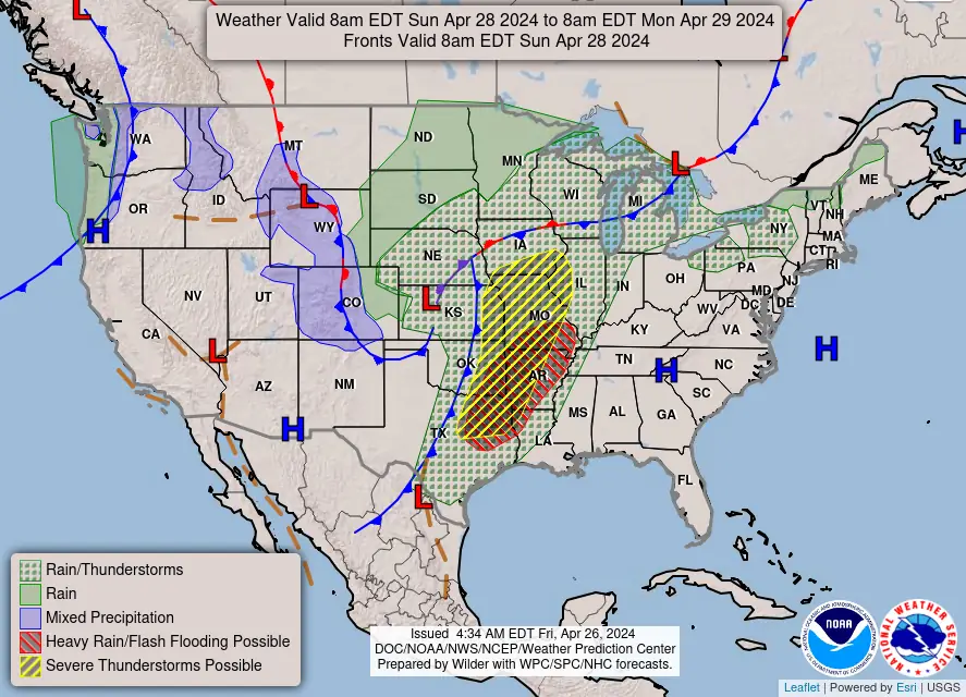
On Sunday, April 28, the severe weather risk is set to extend from northeastern Texas through parts of the Upper Midwest. These storms are anticipated to bring a suite of dangers, including tornadoes, large hail, and damaging wind gusts.
References:
1 Short Range Forecast Discussion – NWS Weather Prediction Center College Park MD – 328 AM EDT Fri Apr 26 2024
2 Tornado Watch issued in Plains as multiday severe weather threat covers up to 55 million – FOX Weather – April 25, 2024
I'm a dedicated researcher, journalist, and editor at The Watchers. With over 20 years of experience in the media industry, I specialize in hard science news, focusing on extreme weather, seismic and volcanic activity, space weather, and astronomy, including near-Earth objects and planetary defense strategies. You can reach me at teo /at/ watchers.news.
Commenting rules and guidelines
We value the thoughts and opinions of our readers and welcome healthy discussions on our website. In order to maintain a respectful and positive community, we ask that all commenters follow these rules.