
Large tornado rips through Barnsdall, Oklahoma, causing massive damage and casualties
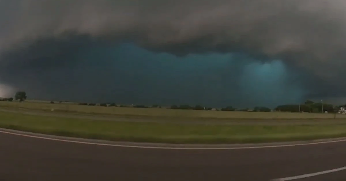
Image credit: Live Storms Media (stillshot)
A very large tornado hit Barnsdall, Oklahoma, at 21:40 local time on May 6 (02:40 UTC on May 7), causing widespread damage. The event resulted in at least one fatality, multiple injuries, and extensive structural damage, including to a nursing home.
- The tornado (preliminary EF4) hit Barsndall, Oklahoma at around 21:40 local time on May 6
- According to initial reports, about 30 – 40 homes and a nursing home were damaged/destroyed, approximately one-third of the town. However, subsequent reports mention catastrophic damage to most of the town.
- This is the first tornado to directly hit Barnsdall since 2008
- One person was killed and multiple others were injured
- Natural gas leaks were reported, leading to much of the town being evacuated
A destructive tornado with an estimated width of about 800 m (0.5 miles) ripped through the small town of Barnsdall (population about 1 000) in Oklahoma’s Osage County at 21:40 LT on Monday, May 6.
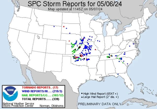
The NWS Storm Prediction Center (SPC) received multiple reports of structural damage and multiple chaser photos and videos of a tornado in and near Barnsdall.
According to the Oklahoma Highway Patrol, at least 30 to 40 homes in Barnsdall were damaged, or about one-third of the town. The Department of Health reported a nursing home was damaged and patients were being evacuated.
Subsequent reports mention catastrophic/life-changing damage to most of the town.
Emergency management officials in Osage County reported a natural gas leak and multiple road closures caused by debris from the tornado. Residents of Barnsdall shared updates on X, describing how large portions of the town were being evacuated as a precaution.
how this was real
— MH Chronicle (@MHNewsDaily) May 7, 2024
Multiple vortices dancing around each other, creating by far the largest #tornado I’ve ever witnessed. So many things I had only seen in other people’s videos or read about in research papers#Oklahoma #Barnsdall #Alert pic.twitter.com/LwgdAZtu6k
I was sent this video by Barnsdall, Oklahoma resident @CalebEaves9 as the tornado entered town. He says his family is okay but much of the town is being evacuated because of gas leaks. They appreciate prayers for the town. #barnsdall #tornado @NWSNorman pic.twitter.com/PnBgiqQoOm
— LoriGrace (@lorigraceaz) May 7, 2024
A lot of help now pouring in. This is the East side of Barnsdall, OK #OKwx @NWStulsa pic.twitter.com/jcGmMaz3rq
— Aaron Rigsby (@AaronRigsbyOSC) May 7, 2024
Scary night, tornado ripped through Barnsdall, OK, and when we arrived on scene had to help a family to safety after they escaped their collapsed home. Search and rescue is ongoing. #tornado #OKwx pic.twitter.com/0P6Tul0FLA
— Jonathan Petramala (@jpetramala) May 7, 2024
“We’ve got one confirmed fatality and multiple injuries,” Osage County Sheriff Eddie Virden said.
“We did take a direct hit from a tornado,” said Kary Fox of the Washington County Emergency Management. “Please stay off the roadways. Stay out of those damaged areas. We’re having a lot of difficulty getting in to do assessments to check on people, to see if they’ve got any injuries because of the traffic congestion.”
Jerry Roberts, the emergency management director in Osage County, described Barnsdall as “still in rescue mode.” In a phone call with The Washington Post early Tuesday, he stated that firefighters and police are “going through the neighborhood trying to locate any trapped persons.” Several individuals have been taken to the hospital, but information on fatalities remains unclear.
Roberts emphasized that the full extent of the damage wouldn’t be known “until we get daylight.” He estimated the tornado’s width to be around 800 m (0.5 miles) but noted that the full path length remained undetermined.
The tornado reached the city of Bartlesville (population ~38 000), located about 24 km (15 miles) NE of Barnsdall, by around 22:00 CDT. It appears it weakened as it passed the city but numerous homes were damaged there, too.
This severe weather event was part of a broader series of storms that had been affecting the region since May 6, marked by intense wind and rain.
The Storm Prediction Center confirmed 17 tornado reports on that day, primarily from Oklahoma, but also from states such as Iowa, Kansas, Nebraska, South Dakota, Missouri, and Tennessee.
In April, the United States experienced over 300 tornadoes, marking it as the second-highest month for tornado activity on record. Within just four days at the end of April, over 140 tornadoes swept through central states, resulting in the deaths of five people, four of whom were in Oklahoma. Many others sustained injuries during the storms
Forecast
“Dangerous severe weather will continue overnight in the nation’s heartland with potentially intense tornadoes and very large hail,” NWS said. “The threat for severe weather will shift eastward into the Ohio Valley and mid-South on Tuesday, May 7. Farther west on the back side of this large storm system, strong winds and critical fire weather will affect the southern and central High Plains through midweek.”
A weather front extending from the Northern Plains to the Middle Mississippi Valley and then to the Southern Plains on Tuesday will generate a low-pressure system over the Upper Great Lakes by Wednesday. The front will continue eastward, moving off the Northeast Coast by Thursday, as another wave of low pressure forms over the Southern Plains and advances to the Ohio Valley.
Tuesday, May 7
As the front progresses eastward, it will bring showers and severe thunderstorms to the Ohio Valley and Middle Mississippi Valley. The Storm Prediction Center (SPC) has issued an Enhanced Risk (level 3/5) of severe thunderstorms in parts of Indiana, western Ohio, and north-central Kentucky. Potential hazards include frequent lightning, severe wind gusts, hail, and a few tornadoes, including EF2 to EF5 tornadoes and hail two inches (5 cm) or greater.
Heavy rain will impact southern Indiana, southwestern Ohio, and north-central Kentucky, with the Weather Prediction Center (WPC) issuing a Slight Risk (level 2/4) of excessive rainfall. Flash flooding is expected in urban areas, roads, small streams, and low-lying regions. Additional thunderstorms are anticipated across the Northeast, Southeast, Southern Plains, Central Gulf Coast, and Upper Great Lakes.
Wednesday, May 8
The next wave of low pressure will advance from the Southern Plains into the Middle/Lower Mississippi Valley, bringing severe thunderstorms to Oklahoma, Texas, Missouri, Arkansas, Kentucky, southeastern Illinois, southern Indiana, Tennessee, and Mississippi. The SPC has issued an Enhanced Risk (level 3/5) for the Ohio/Tennessee Valleys, Middle/Lower Mississippi Valley, and Southern Plains.
Hazards include frequent lightning, severe wind gusts, hail, and a few tornadoes. EF2 to EF5 tornadoes are likely in the Middle Mississippi Valley and Ohio/Tennessee Valleys, with hail 5 cm (2 inches) or greater expected.
The WPC has issued a Slight Risk (level 2/4) of excessive rainfall across the Ohio/Tennessee Valleys and Middle/Lower Mississippi Valley. Heavy rain may cause localized flash flooding in urban areas, roads, and low-lying regions. Showers and thunderstorms will also develop over the Northeast and Southeast.
Update
22:07 UTC, May 8
The tornado received a preliminary rating of EF4.
“Based on our survey so far and review of radar data, we believe this is likely one single tornado that began southeast of Hominy,” meteorologists at the NWS office in Tulsa, OK said.
The full preliminary survey result continues:
The tornado crossed Highway 20, snapping numerous trees and breaking metal power poles. We were able to transect the path several times between Highway 20 and Barnsdall. Significant tree damage was found in several locations. The tornado then moved into Barnsdall, causing severe damage to the wax plant on the southeast side of town, and then severely damaged or destroyed numerous homes on the east side of town.
Several homes and a well-built, metal-framed building suggested estimated wind speeds in the 241 to 266 km/h range (150 to 165 mph), and one home suggested estimated wind speeds of 266 to 282 km/h (165 to 175 mph), which is in the EF4 category.
Numerous trees were snubbed in the area of some of the higher end damage, which was supportive of these wind speed estimates. Significant tree damage continued northeast of Barnsdall, a few homes were damaged and outbuildings were destroyed between Barnsdall and Bartlesville.
The tornado moved across the southern portion of Bartlesville, and then across the eastern side of town. Lots of trees were snapped or uprooted, and numerous homes and businesses were damaged in town. A squall line merged with the tornadic supercell, and ultimately ended the tornado process on the northeast side of Bartlesville.
Radar data suggested that the merger may have produced an additional tornado near Dewey, but no damage was found in that area when we investigated it today.
There are several other locations where tornadoes likely occurred Monday evening that we plan to survey over the coming days across eastern Oklahoma and northwestern Arkansas, and we will do this as soon as possible. Additional severe weather in our area on Wednesday will likely hamper making much progress on this, but the weather later in the week will be favorable for conducting these damage surveys.
Additionally, there are other areas within the Barnsdall tornado path that we will be evaluating, hopefully through aerial imagery, to finalize that path as best we can. We will send additional Public Information Statements this week with details of our surveys.
References:
1 Severe thunderstorms, long-track tornadoes, and large hail target Oklahoma and Kansas starting May 6 – The Watchers – May 6, 2024
2 SPC Storm Reports for May 6, 2024
3 Short Range Forecast Discussion – NWS Weather Prediction Center College Park MD – 359 AM EDT Tue May 07 2024
4 Tornado causes extensive damage to Oklahoma town and 1 death as powerful storms hit central US – AP – May 5, 2024
5 Catastrophic damage, at least 4 fatalities after severe tornado outbreak hits Oklahoma – The Watchers – April 29, 2024
6 Marietta tornado rated EF4, Oklahoma’s first violent tornado in 8 years – The Watchers – April 30, 2024
I'm a dedicated researcher, journalist, and editor at The Watchers. With over 20 years of experience in the media industry, I specialize in hard science news, focusing on extreme weather, seismic and volcanic activity, space weather, and astronomy, including near-Earth objects and planetary defense strategies. You can reach me at teo /at/ watchers.news.
Commenting rules and guidelines
We value the thoughts and opinions of our readers and welcome healthy discussions on our website. In order to maintain a respectful and positive community, we ask that all commenters follow these rules.