
Severe thunderstorms, long-track tornadoes, and large hail target Oklahoma and Kansas starting May 6
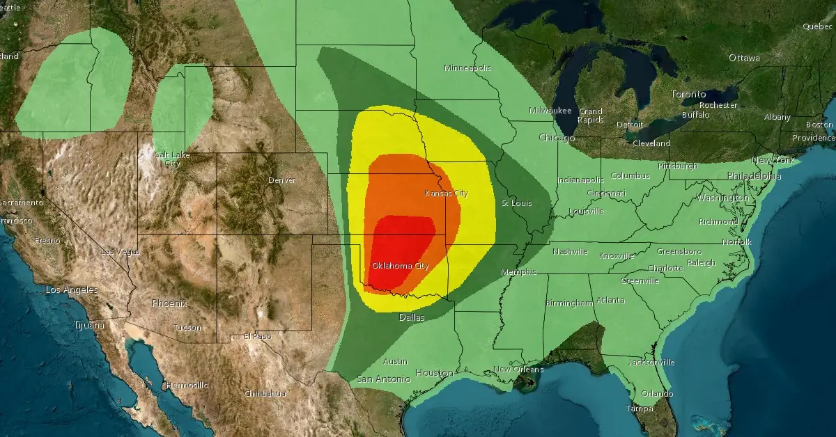
Image credit: NWS/ESRI, The Watchers
A significant severe weather outbreak is forecast to impact millions across the Central United States, starting on Monday, May 6, 2024. Meteorological conditions indicate potential for long-track tornadoes, large hail, and hurricane-force wind gusts, posing increased risk to regions still recovering from recent extreme weather events.
- Numerous severe thunderstorms are expected to develop and move eastward Monday afternoon, May 6 through Monday night across parts of the southern/central Plains. Multiple intense, long-track tornadoes, very large to giant hail, and severe/damaging winds all appear likely.
The overall synoptic setup indicates a severe weather outbreak occurring this afternoon [Monday, May 6] and extending into the evening and parts of the overnight period, NWS Storm Prediction Center forecasters Wendt and Darrow said on May 6.
Multiple intense, long-track tornadoes are expected, especially in parts of southern Kansas into Oklahoma. Very large hail of up to 5 to 10 cm (2 – 4 inches) can also be expected with intense supercells. Severe gusts may initially be isolated, but storm coverage should increase with time as well as the mode becoming more linear. As this occurs, severe gusts, some up to 130 km/h (80 mph), will become more common.
Storm coverage is likely to initially be greatest in south-central Kansas given the greater and earlier upper-level forcing, with isolated storms still possible along the dryline in western Oklahoma as strong heating in the Texas Panhandle should support dryline circulations that should at least locally erode inhibition.
“By the evening, greater forcing for ascent will arrive in western Oklahoma. Flow aloft will be nearly perpendicular to the dryline, which will favor a discrete storm mode… Overall, there appears to be prolonged opportunity for discrete storms to form across western Oklahoma into parts of southern Kansas.
“While the environment during the afternoon will certainly support intense, long-track tornadoes, concern only grows by early evening. Discrete storms are expected to move eastward into an intensifying low-level jet core in central and eastern Oklahoma into southeast Kansas. Surface-based activity will likely persist into the evening and even parts of the overnight, given continued influx of moisture and weak capping. The time frame of greatest concern for intense tornadoes is from 03-06Z [UTC, May 7] across central into northeast Oklahoma.”

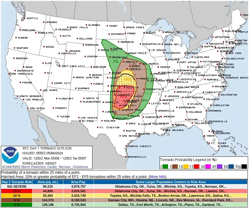
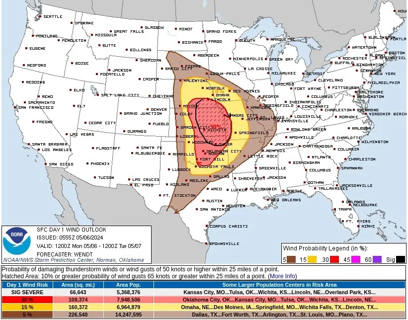

More than 28 million residents from Texas to South Dakota are initially forecast to be at risk, with south-central Kansas and western and central Oklahoma under a Level 4 out of 5 severe thunderstorm risk according to the NOAA’s Storm Prediction Center (SPC).
Cities such as Oklahoma City, Norman, Lawton, and Edmond in Oklahoma, along with Wichita in Kansas, are advised to be particularly vigilant. The SPC has also flagged the potential for strong tornadoes (EF-2 or higher) and very large to giant hail — over 7 cm (2.75 inches) in diameter, in these areas.
Simultaneously, a frontal system extending from the Northern Rockies/Northern High Plains to the Southern Rockies is expected to advance eastward, influencing weather across a broader area. According to the NWS forecaster Ziegenfelder, this system will also interact with moisture streaming northward from the Gulf of Mexico, enhancing the potential for severe thunderstorms and heavy rainfall across the Plains into the Ohio Valley.
The SPC has placed nearly 25 million people in the mid-South to the Ohio Valley under a Level 2 severe thunderstorm risk for May 7, encompassing cities such as Indianapolis, Nashville, Memphis, Little Rock, Paducah, Cincinnati, and Columbus. Main threats include hail and damaging wind gusts.
Further east, the SPC anticipates a risk of severe weather for over 44 million people in cities including Chicago, St. Louis, and Indianapolis, though these predictions remain subject to change as the situation develops.
Residents in the affected areas are urged to prepare for these severe conditions by securing safe shelter and staying informed through updates. The expected conditions include winds potentially reaching Category 1 hurricane strength in the hardest-hit areas on May 6, with ongoing threats as the system moves eastward.
References:
1 Short Range Forecast Discussion – NWS Weather Prediction Center College Park MD 349 AM EDT – Mon May 06 2024
2 Severe weather outbreak could threaten millions in central US on Monday – FOX Weather – May 5, 2024
I'm a dedicated researcher, journalist, and editor at The Watchers. With over 20 years of experience in the media industry, I specialize in hard science news, focusing on extreme weather, seismic and volcanic activity, space weather, and astronomy, including near-Earth objects and planetary defense strategies. You can reach me at teo /at/ watchers.news.
Sue the companies that are responsible for the cloud seeding!