
Rare tornado emergency south of Nashville as severe thunderstorms leave 2 dead in Tennessee

Image credit: Live Storms Media (stillshot)
A severe weather outbreak on May 8, 2024, spawned a ‘large and destructive’ tornado south of Nashville, Tennessee, killing at least 1 person, injuring several, and leaving widespread damage.
- The storm prompted a rare tornado emergency, affected over 200 000 residents across multiple states, and left at least 2 people dead.
- This was the third consecutive day of severe weather outbreak in the United States.
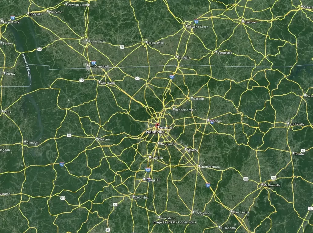
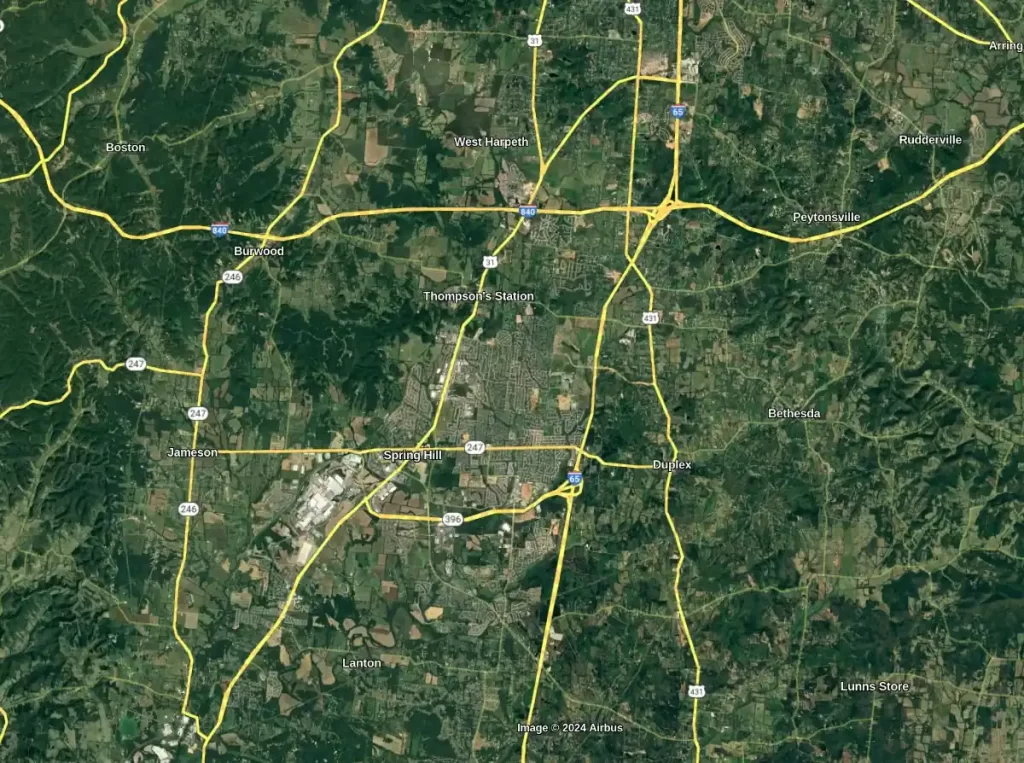
The National Weather Service (NWS) office in Nashville issued a rare tornado emergency for southern Maury County, southern Williamson County, and southwestern Rutherford County on May 8, shortly after an intense thunderstorm moved over Columbia, Tennessee.
This emergency alert cited “a confirmed large and destructive tornado” was on the ground near Spring Hill (population 55 800) — located some 50 km (31 miles) south of Nashville and 16 km (10 miles) northeast of Columbia — moving northeast at 40 km/h (25 mph). The alert was released at 17:53 CDT (22:53 UTC), just moments before the tornado crossed Interstate 65.
Widespread building and tree damage was reported, prompting county officials to advise residents to stay off the roads.
While the full extent of the damage is still unknown, one person has died and four others were injured in Maury County, as confirmed by Rita Thompson, a spokesperson for Maury Regional Medical Center. Three of the injured have non-life-threatening injuries, while one is in serious condition.
Tornadoes were also reported in Robertson County, and large hail was recorded in Clarksville.
According to the NWS, four tornadoes were reported across Tennessee, with two occurring in Maury County where the tornado emergency was declared.
A second fatality was reported earlier that day in Claiborne County when a tree fell onto a person’s car amid the severe storms.
The NWS Storm Prediction Center received 13 tornado reports across six states on May 8, including:
- Tennessee: 4 reports (Fredonia, Coopertown, Columbia, Spring Hill)
- Illinois: 3 reports (Carbondale, Carrier Mills, Equality)
- Missouri: 2 reports (Monett, Pleasant Ridge)
- Kentucky: 1 report (Rockcastle)
- Texas: 1 report (Toco)
- South Dakota: 1 report (Cavour)
As of 07:20 UTC (02:20 CDT) on May 9, over 200 000 customers are without power across multiple states, including nearly 100 000 in North Carolina, 42 000 in Tennessee, 32 000 in both South Carolina and Georgia, and 18 000 in Missouri.
Severe thunderstorms and heavy rainfall are expected to persist from the Mississippi, Ohio, and Tennessee Valleys into the southern Plains. The severe weather threat is anticipated to shift south on Thursday, May 9 toward the Southern Plains and Southeast.
On Monday, May 6 (LT) — on the first day of this severe weather outbreak, a very large tornado hit Barnsdall, Oklahoma, causing widespread damage. The event resulted in at least one fatality, multiple injuries, and extensive structural damage, including to a nursing home. On May 8, it received a preliminary rating of EF4.
Late Tuesday (LT), May 7, Michigan Governor Gretchen Whitmer declared a state of emergency after a series of tornadoes pummeled the upper Midwestern state, injuring up to 20 people and causing significant damage in Portage and other areas.
This multiday severe weather outbreak follows closely on the heels of another destructive event that began on April 26, where at least 78 tornadoes struck the U.S. Plains.
The tornado that hit Marietta, Oklahoma at 23:08 CDT on April 27, was rated EF4 by the NWS, making it Oklahoma’s first violent tornado in nearly 8 years. This event resulted in one fatality and extensive structural damage across multiple counties.
This severe tornado outbreak has resulted in the deaths of at least four individuals and inflicted significant destruction across several cities in Oklahoma, marking one of the most destructive days in the state’s recent history.
“On Thursday, [May 9] a front extending from the Mid-Atlantic westward to the Ohio Valley and then southwestward to the Southern High Plains will move eastward off most of the Mid-Atlantic Coast by Friday evening, lingering over Florida on Saturday,” NWS forecaster Ziegenfelder noted.
As this boundary moves across the Lower Mississippi Valley into the Southeast on Friday, it will trigger showers and severe thunderstorms in eastern Texas, Louisiana, central Mississippi, Southern Alabama, and southern Georgia.
The Storm Prediction Center (SPC) has elevated the area to an Enhanced Risk (level 3/5) for severe thunderstorms through Friday morning, affecting the Southern Plains, Lower Mississippi Valley, Tennessee Valley, and Southeast. These storms may bring frequent lightning, severe wind gusts, hail, and possible tornadoes. Specific regions could experience wind gusts exceeding 120 km/h (75 mph) and hail larger than 5 cm (2 inches) in diameter.
Additionally, the Weather Prediction Center (WPC) has placed a Slight Risk (level 2/4) for excessive rainfall in these regions through Friday morning. Expected heavy rains could lead to localized flash flooding, particularly in urban areas, on roads, and in low-lying regions near small streams.
On Thursday, the Mid-Atlantic, Central Plains, and Middle Mississippi Valley will also see development of showers and thunderstorms. As the front progresses, the remainder is expected to move off the Atlantic Coast by Friday, but will persist over Florida on Saturday, continuing to pose a risk for severe weather in southern Georgia, southeastern South Carolina, and northeastern Florida. The SPC has identified a Slight Risk (level 2/5) for severe thunderstorms in these areas from Friday into Saturday morning.
In response, the WPC has issued a Marginal Risk (level 1/4) for excessive rainfall across the Central Gulf Coast and Southeast from Friday into Saturday. This rain may cause additional localized flash flooding in areas prone to rapid runoff.
Track this and previous tornado outbreaks visually via Stormwall.
To learn more about this severe weather outbreak see our previous reports:
References:
1 Tennessee tornado and storm damage reports: See where they’ve been reported in greater Nashville area – The Tennessean – May 8, 2024
2 NWS Storm Prediction Center (SPC) – tornado reports for May 8, 2024
I'm a dedicated researcher, journalist, and editor at The Watchers. With over 20 years of experience in the media industry, I specialize in hard science news, focusing on extreme weather, seismic and volcanic activity, space weather, and astronomy, including near-Earth objects and planetary defense strategies. You can reach me at teo /at/ watchers.news.
Commenting rules and guidelines
We value the thoughts and opinions of our readers and welcome healthy discussions on our website. In order to maintain a respectful and positive community, we ask that all commenters follow these rules.