
Severe storms bring flooding to southeastern U.S., Texas mobilizes emergency response
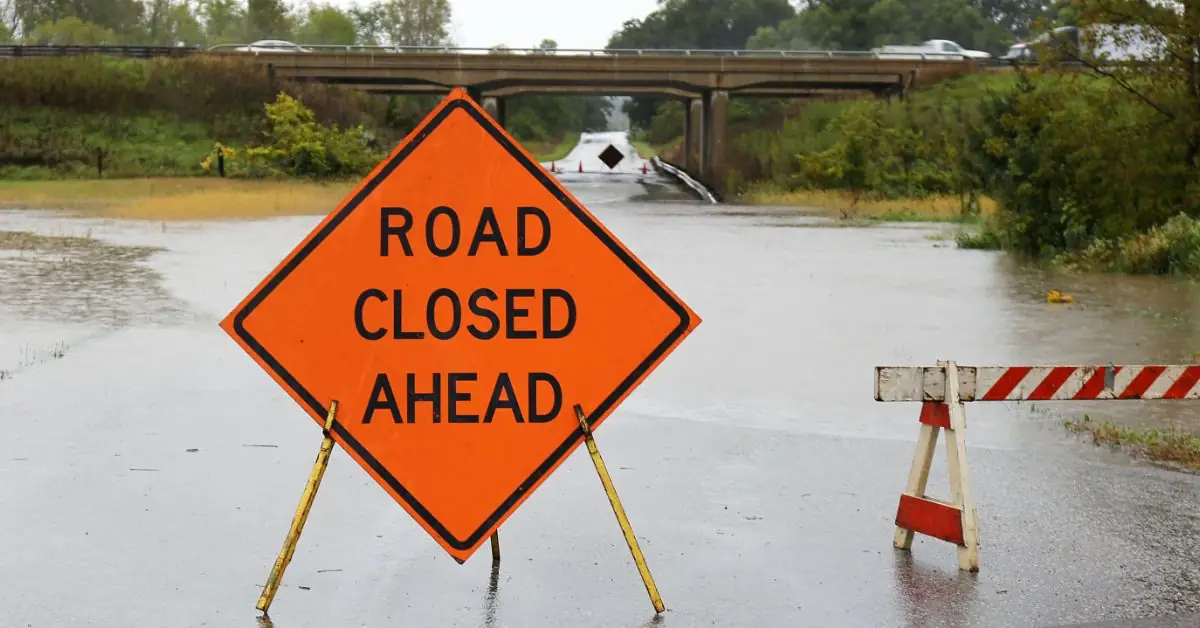
Image credit: Texas Department of Transportation
Heavy downpours and thunderstorms continued to affect the southeastern United States, particularly Texas, resulting in severe flooding and road blockages. Governor Greg Abbott activated emergency response teams to mitigate flash flooding risks as the Guadalupe River in Kerrville reached flood levels for the first time since 2018.
Torrential rain and thunderstorms continue to batter the southeastern United States, with severe weather predicted to persist through the weekend.
On July 23, several regions across Texas faced severe flooding and road blockages due to heavy downpours.
In Kerrville, the Guadalupe River reached flood levels for the first time since 2018, as the area received 50 – 100 mm (2 – 4 inches) of rain per hour at times on the morning of July 23. The river is expected to rise 1.21 m (4 feet) by the evening of July 24.
And in local news this is what the Guadalupe River looks like behind where I live. And it's expected to rise another 4 feet this evening. Yes I'm safe. pic.twitter.com/bTnX1WqrYE
— Beyond Blonde (@BeyondBlonde3) July 23, 2024
Urgent Update Out of Kerr County #TX21 pic.twitter.com/8cH59WfvhD
— Chip Roy (@chiproytx) July 23, 2024
Texas Governor Greg Abbott has directed the Texas Division of Emergency Management (TDEM) to activate state emergency response resources ahead of flash flooding threats from severe storms moving across the state.
Today, I directed @TDEM to activate state emergency response resources ahead of flash flooding threats from severe storms.
— Gov. Greg Abbott (@GovAbbott) July 24, 2024
Texas stands ready to help protect Texans and communities across the state.
More: https://t.co/QMQM5V3sU6 pic.twitter.com/2m1BMnen9D
“As storms with heavy rainfall move across our state, communities in East Texas and the Coastal Bend are urged to remain weather aware and be mindful of flash flood risks,” said Governor Abbott in a news release on July 23.
“Today, I directed the Texas Division of Emergency Management to activate state emergency response resources to support local officials with flood response operations. The State of Texas stands ready to help protect Texans and communities across the state as severe storms bring heavy rainfall and flash flooding threats. Remember: Turn Around, Don’t Drown,” the governor added.
Multiple rounds of heavy rainfall are expected today through the weekend, bringing an increased risk of flash flooding to the southern half of the state. River flooding is also expected across East/Southeast Texas, with that threat expanding towards the Coastal Bend mid-week, according to the National Weather Service
Coastal Texas, Louisiana, and the Carolinas are expected to experience the heaviest rainfall and the highest risk of flash flooding.
While the Southeast will see intermittent sunshine and typical late-July heat, the region will remain prone to severe downpours, according to AccuWeather’s senior meteorologist Alex Sosnowski.
From July 23 to July 27, the Texas coast to western Louisiana is projected to receive 25 – 102 mm (1 – 4 inches) of rain, with localized areas potentially seeing 102 – 203 mm (4 – 8 inches). An AccuWeather Local StormMax of 381 mm (15 inches) is forecasted.
In Houston, blocked drains from debris left by Beryl may exacerbate flooding issues.
“The main funnel of moisture from the Gulf of Mexico will be directed toward southeastern Texas and part of Louisiana through July 26 and possibly into the weekend,” said AccuWeather Meteorologist Brandon Buckingham.
“Some of that rain will fall within a couple of hours, overwhelming storm drains and causing flash flooding in cities such as Brownsville, Corpus Christi, Victoria, Houston, and Port Arthur. Driving through flooded roads can be dangerous, as water may rise rapidly, be fast-flowing, or conceal washed-away roadways.”added Buckingham
Some downpours are expected farther inland over Texas to portions of the Interstate 35 corridor, providing relief from drought conditions in central Texas, benefiting residents, agriculture, and watershed management. Metro areas like San Antonio and Austin, as well as Laredo, should expect some rain.
Northern parts of Alabama, Mississippi, southeastern Arkansas, and southern Tennessee will also experience downpours.
An enhanced zone will develop over the Carolinas, where 25 – 102 mm (1 – 4 inches) of rain with locally higher amounts are expected through July 26. Cities such as Charlotte, Raleigh, Columbia, and Charleston are at risk for flash flooding.
Across the Southeast, there will be a mosaic of shower and thunderstorm activity through the weekend. Any rainfall will benefit groundwater, small streams, and reservoirs, particularly in drought-stricken areas.
Localized flash flooding and afternoon storm wind gusts pose risks, particularly near airports like Atlanta, Houston, and Charlotte, potentially causing flight delays and cancellations.
References:
1 Showers, storms to continue in Southeast, but will hammer 2 main areas – AccuWeather – July 23, 2024
2 Downpours, storms drench millions along 1,000-mile stretch from Texas to mid-Atlantic – FOX Weather – July 21, 2024
3 Heavy Rain Floods Roads In Central Texas –The Weather Channel – July 24, 2024

I am an Assistant Editor and Severe Weather & Science Journalist at The Watchers, specializing in real-time severe weather coverage, geophysical event reporting, and research-driven scientific analysis. You can reach me at rishav(at)watchers(.)news.
Commenting rules and guidelines
We value the thoughts and opinions of our readers and welcome healthy discussions on our website. In order to maintain a respectful and positive community, we ask that all commenters follow these rules.