
Alert Level for Kilauea volcano raised to Watch, Hawaii

Image credit: TW/SAM, ESRI
Increased earthquake activity and ground deformation at Kīlauea’s upper East Rift Zone began at approximately 13:30 UTC (03:30 HST) on July 23, 2024, indicating likely magma movement in the subsurface. This activity has prompted Hawaiʻi Volcanoes National Park to close areas that could put visitors and staff at risk if the volcano erupts.
Accordingly, the USGS Hawaiian Volcano Observatory (HVO) has raised the Volcano Alert Level for ground-based hazards from ADVISORY to WATCH and the Aviation Color Code from YELLOW to ORANGE.
Earthquake activity is centered near Pauahi Crater, HVO volcanologists reported. “The situation is rapidly evolving, and it is not possible to determine if this activity will lead to an eruption or remain below ground.”
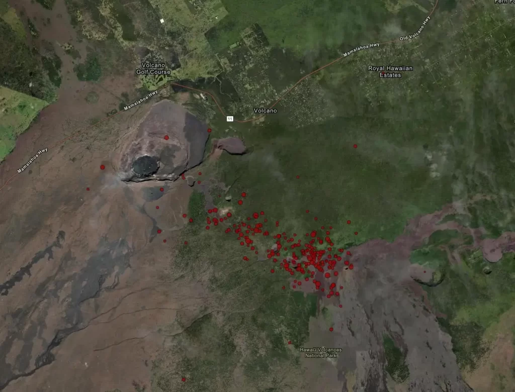
An eruption in Kīlauea’s upper East Rift Zone within Hawai‘i Volcanoes National Park is one potential outcome.
Based on past eruptive patterns, the area between Hiʻiaka Crater and Maunaulu in Hawai‘i Volcanoes National Park is potentially at risk for a new lava outbreak.
Past eruptions in this region of Kīlauea’s upper East Rift Zone, between Hiʻiaka Crater and Maunaulu, occurred over hours to about a month. The location of any future outbreak will determine which areas could be in the path of new lava flows.

This activity has prompted Hawaiʻi Volcanoes National Park to close areas that could put visitors and staff at risk if the volcano erupts.
“It is never an easy decision to close areas, but it is the right thing to do. Safety is always our top priority,” said Park Superintendent Rhonda Loh.
The temporary closures include Chain of Craters Road from the intersection at Devastation parking lot to the coast, Kulanaokuaiki Campground, Crater Rim Trail south of Nāhuku lava tube, and coastal backcountry areas along with Nāpau sites, with all new backcountry permits for those areas canceled. Additionally, Escape Road is closed from Nāhuku to Maunaulu.
“We remain in constant communication with scientists at the USGS Hawaiian Volcano Observatory and will continue to notify the public of any changes,” Loh said.
Risks include the uncertainty of where an eruption could break out, the potential for elevated volcanic gases, dangerous lava flows, damaging earthquakes, and lava-ignited wildfires.
Updates
19:39 UTC, July 23
Localized earthquake and ground deformation rates in Kīlauea’s upper East Rift Zone decreased significantly following the burst of intense activity earlier today.
Accordingly, the HVO has lowered the Volcano Alert Level for ground-based hazards from WATCH to ADVISORY and the Aviation Color Code from ORANGE to YELLOW.
19:43 UTC, July 23
As of 19:43 UTC, seismicity and ground deformation rates have decreased but remain elevated, HVO reported.
The pulsing nature of this activity may represent stages in intrusive activity beneath the upper East Rift Zone region. Additional seismic pulses or swarms may occur with little or no warning and result in either continued intrusion of magma or eruption of lava.
Changes in the character and location of unrest can occur quickly, as can the potential for eruption, but there are no signs of an imminent eruption at this time.
Over the past 24 hours, there were approximately 50 earthquakes detected beneath Kīlauea’s summit and approximately 357 earthquakes detected beneath the upper East Rift Zone, mostly at depths of 0 – 4 km (up to 2.5 miles) beneath the ground surface.
The most significant increase in earthquake counts was observed beneath the upper East Rift Zone with three times the 111 events detected beneath the upper East Rift Zone in the previous 24 hours. Most events were smaller than M2, but there were 13 earthquakes M3 or higher in the upper East Rift Zone. The largest event was M3.4.
References:
1 Volcano Observatory Notice For Aviation (VONA) – Kilauea Volcano – USGS/HVO – Issued at 14:06 UTC on July 23, 2024
2 Chain of Craters Road and other areas closed as earthquakes increase in Hawaiʻi Volcanoes National Park – NPS – July 22, 2024
I'm a dedicated researcher, journalist, and editor at The Watchers. With over 20 years of experience in the media industry, I specialize in hard science news, focusing on extreme weather, seismic and volcanic activity, space weather, and astronomy, including near-Earth objects and planetary defense strategies. You can reach me at teo /at/ watchers.news.
Commenting rules and guidelines
We value the thoughts and opinions of our readers and welcome healthy discussions on our website. In order to maintain a respectful and positive community, we ask that all commenters follow these rules.