
High-risk weather system with tornadoes, very large to giant hail targets central U.S. into May 9
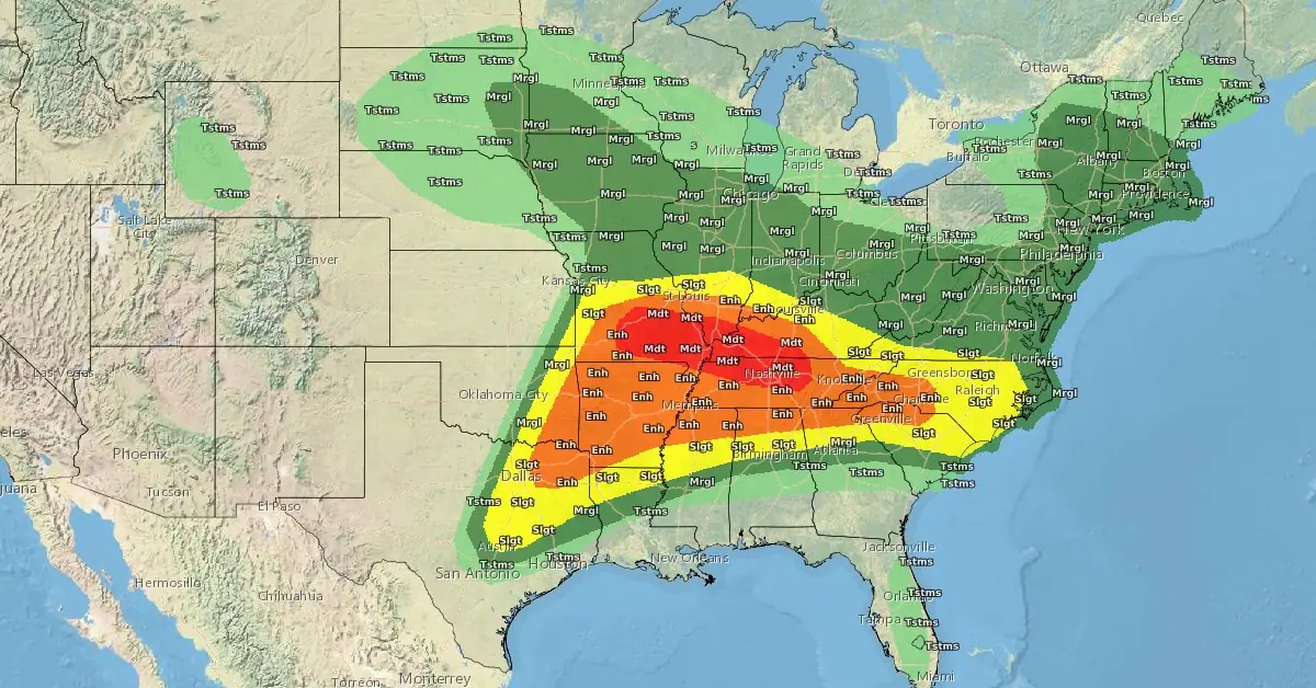
Image credit: NWS
A severe storm system is forecast to affect over 75 million people across the mid-Mississippi, Ohio, and Tennessee Valleys, and the southern Plains on May 8 and 9, 2024.
- Meteorologists predict that the storms will bring tornadoes, very large to giant hail, and damaging winds, potentially resulting in significant destruction and disruptions across the region.
- Some tornadoes may be strong, NWS Storm Prediction Center warns.
- The high-risk zone includes densely populated areas from southeastern Missouri and northeastern Arkansas to western and central Kentucky.
The central United States is bracing for another severe weather day on the afternoon (LT) of May 8 into 9, 2024, with thunderstorms expected to deliver all hazards, including tornadoes, very large to giant hail, and damaging winds.
The storms are projected to sweep through parts of the mid-Mississippi, Ohio, and Tennessee Valleys into the southern Plains, with tornadoes potentially growing strong and widespread, the National Weather Service warns.
AccuWeather meteorologists have also issued warnings, noting that this event could be ‘the biggest day in terms of impact and the number of incidents ranging from tornadoes to damaging winds and hail.’
“There could easily be over a dozen tornadoes produced at midweek alone,” Bernie Rayno, AccuWeather Chief On-Air Meteorologist, said.
The high-risk zone spans southeastern Missouri and northeastern Arkansas through southern Illinois, western and central Kentucky, and northwestern and middle Tennessee. More densely populated areas than the Great Plains are at risk, potentially affecting over 75 million people.
Major cities likely to experience severe weather include Nashville and Memphis, Tennessee; Louisville and Paducah, Kentucky; Cincinnati; Indianapolis and Evansville, Indiana; St. Louis and Cape Girardeau, Missouri; Little Rock and Texarkana, Arkansas; Springfield, Illinois; and Dallas.
The Storm Prediction Center has issued a Moderate Risk (level 4/5) of severe weather between south-central Missouri to Middle Tennessee and south-central Kentucky. “Additionally, as storms overlap with saturated soil from earlier rainfall and train behind one another, numerous instances of flash flooding are possible,” NWS forecaster Snell said.
The greatest risk for flash flooding is across southwestern Kentucky and Middle Tennessee, where a Moderate Risk (level 3/4) of Excessive Rainfall is in effect.
By Thursday, May 9, the overnight thunderstorm activity is anticipated to sink southward and impact areas from the Southern Plains to the Southeast. Very large hail appears probable across parts of central Texas and into the ArkLaTex region, with a broader region of severe hail and damaging wind potential extending through the lower Mississippi Valley into the Southeast.
Areas of flash flooding are also possible along this corridor stretching between eastern Texas and central Georgia. As the associated cold front continues to push south and east on Friday, the scattered thunderstorms threat is expected to linger, but remain confined to the Southeast.
Residents are advised to prepare for the storm by securing outdoor objects, having emergency kits ready, and following local alerts to stay informed about changing weather conditions.
Updates
22:32 UTC, May 8
At 21:00 UTC (16:00 CDT) on May 8, seven tornado watches were active from Texas to Tennessee. In the Carolinas, a severe thunderstorm watch was in effect after storms swept through the Charlotte area, leaving 130 000 customers without power. Gaston and Mecklenburg counties accounted for approximately 100 000 of those outages.
As of 22:30 UTC, 139 157 customers are without power in North Carolina, 14 986 in Michigan, and 14 446 in Missouri.
The Storm Prediction Center has so far received 8 tornado reports — 3 from Illinois, 2 from Tennessee, and one each from Kansa, Kentucky and Missouri.
There were multiple reports of a tornado in the Monett area, Barry County, Missouri. Videos of tornadoes were also sent from Carbondale in Williamson County, Illinois; Rockcastle in Trigg County, Kentucky; and Carrier Mills in Saline County, Illinois.
You can track this and previous tornado outbreaks visually via Stormwall.
References:
1 Short Range Forecast Discussion – NWS Weather Prediction Center College Park MD – 349 PM EDT Wed May 08 2024
2 Tornado outbreak to continue in for 3rd day in central US – AccuWeather – May 8, 2024
I'm a dedicated researcher, journalist, and editor at The Watchers. With over 20 years of experience in the media industry, I specialize in hard science news, focusing on extreme weather, seismic and volcanic activity, space weather, and astronomy, including near-Earth objects and planetary defense strategies. You can reach me at teo /at/ watchers.news.
Commenting rules and guidelines
We value the thoughts and opinions of our readers and welcome healthy discussions on our website. In order to maintain a respectful and positive community, we ask that all commenters follow these rules.