
Severe thunderstorms in northwest Texas
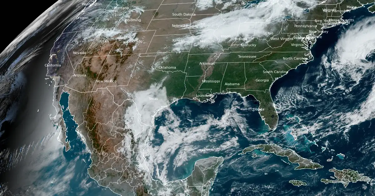
Image credit: NOAA/GOES-East, RAMMB/CIRA, The Watchers. Acquired at 14:10 UTC on April 23, 2024
Severe thunderstorms are forecasted for northwest Texas this afternoon and evening, April 23, 2024, with the potential for large hail and damaging wind gusts. This weather shift comes as part of a broader pattern affecting the Great Plains and Midwest, initiated by a developing upper trough over the western U.S. and a series of cold fronts impacting the Great Lakes and Ohio Valley. The Storm Prediction Center has issued a Slight Risk alert for northwest Texas today due to these conditions.
Residents of northwest Texas were warned to prepare for an afternoon and evening of severe weather conditions, including the possibility of large hail and damaging winds. The Storm Prediction Center (SPC) has elevated the region to a Slight Risk (level 2 out of 5) for severe weather today.
This severe weather threat is part of a larger atmospheric pattern shift affecting much of the United States. Over the past few days, the Lower 48 has experienced relatively calm weather, but this is set to change with the development of an upper trough over the western U.S. This system is expected to catalyze increased thunderstorm activity across the Great Plains and parts of the Midwest starting midweek.
Currently, a pair of cold fronts are moving across the Great Lakes and Ohio Valley, bringing showers and isolated thunderstorms to these areas. These conditions are anticipated to reach the Northeast by Wednesday, April 24 with temperatures potentially dropping quickly enough in northern New England to turn precipitation into snow.
Meanwhile, a trailing cold front is moving into the southern Plains, focusing the potential for thunderstorms from northern and West Texas to central Oklahoma over the next few days. Alongside the large hail and wind threats in northwest Texas today, isolated severe thunderstorms could also develop along a southern High Plains dryline by Wednesday.
Looking ahead to Thursday, the upper-level system will support more widespread showers and thunderstorm activity across the central and southern Plains. Severe thunderstorms are likely, especially as low pressure develops over the central High Plains and a strengthening dryline moves eastward. The most severe threats during this period are expected between south-central Nebraska and northern Texas.
In addition to the severe thunderstorm potential, there is a concern for isolated flash flooding due to heavy rainfall. Outside of these severe conditions, parts of the Great Basin and eventually the Pacific Northwest are also forecasted to experience unsettled weather by Thursday as temperatures begin to cool from previously above-average highs.
On Friday, April 26, the severe weather threat will shift to the eastern Great Plains and the mid-Mississippi Valley. Eight states from Texas to Iowa will be in a Level 2 out of 5 risk, which includes major cities like Dallas and Waco in Texas, Oklahoma City and Tulsa in Oklahoma, Kansas City and Springfield in Missouri, and Des Moines in Iowa.
Large hail and damaging wind gusts will be some of the threats associated with thunderstorms that develop, FOX Weather meteorologists said. However, the threat of tornadoes may be a bit higher than what is expected on Thursday.
The severe weather threat will again target the southern and central Plains and the mid-Mississippi Valley on Saturday, with portions of North Texas, most of Oklahoma, central and eastern Kansas, and western and northern Missouri seeing the highest risk of storms for the first part of the weekend.
The SPC said that daytime heating will allow for storms to develop, and those storms could continue as we get into Saturday evening.
In the southwest, temperatures are expected to remain between 27 and 34 °C (80 – 93 °F) through Wednesday, with cooler temperatures between 15 and 24 °C (59 – 75 °F) across much of the Intermountain West.
The eastern U.S., including the Great Lakes region, is experiencing cooler weather, with morning frost warnings from the southern Appalachians to southern New England, where lows have dipped to -1 to 4 °C (32 – 39 °F). Temperatures are set to rebound this afternoon, with highs reaching 15 – 24 °C (59 – 75 °F) ahead of the next cold front.
References:
1 Short Range Forecast Discussion – NWS Weather Prediction Center College Park MD – 333 AM EDT Tue Apr 23 2024
2 Another multiday severe weather threat looms for at least 8 states across US this week – FOX Weather – April 23, 2024
I'm a dedicated researcher, journalist, and editor at The Watchers. With over 20 years of experience in the media industry, I specialize in hard science news, focusing on extreme weather, seismic and volcanic activity, space weather, and astronomy, including near-Earth objects and planetary defense strategies. You can reach me at teo /at/ watchers.news.
Commenting rules and guidelines
We value the thoughts and opinions of our readers and welcome healthy discussions on our website. In order to maintain a respectful and positive community, we ask that all commenters follow these rules.