
Major flooding and mandatory evacuations in southeast Texas
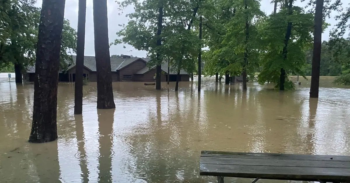
Image credit: Texas Parks & Wildlife
Southeastern Texas has experienced severe flooding this week, affecting areas from College Station to Houston. The flooding has led to the overflowing of rivers, including the Trinity and San Jacinto, causing significant disruptions and leading to urgent evacuations. Heavy rain continued into Friday, May 3, 2024, worsening the flood situation.
Areas near Trinity have recorded between 150 and 230 mm (6 – 9 inches) of rainfall, and Groveton in Trinity County received nearly 280 mm (11 inches) of rain from Sunday, April 28 to Thursday, May 2. As the week progressed, the northern part of Harris County reported receiving between 250 mm and 300 mm (10 – 12 inches) of rainfall within a 24-hour period.
The Navasota River near Easterly set a historic peak at 30.62 m (100.43 feet), which is the highest recorded since June 1, 1899, when it reached 29 m (95 feet).
The situation prompted local authorities to carry out evacuations, especially in neighborhoods along the Trinity and San Jacinto rivers, where water levels continued to rise dangerously.
In response to the rising floodwaters, both voluntary and mandatory evacuations were ordered in various communities. In Harris County, Judge Lina Hidalgo issued a disaster declaration, particularly for residents near the East Fork of the San Jacinto River. San Jacinto County officials also ordered evacuations for residents living below the Lake Livingston Dam and along the Trinity River.
Despite the evacuation orders, some residents chose to stay, resulting in several emergency rescues. The Huffman Volunteer Fire Department reported that their first rescue involved an individual who initially refused to evacuate but later recognized the imminent danger as the water levels rose rapidly.
Emergency response teams, including high-water rescue trucks, have been deployed across the affected areas to assist with evacuations and rescues. Montgomery County officials have urged residents along the West Fork of the San Jacinto River to evacuate to higher ground immediately due to significant river level rises following water release from the Lake Conroe Dam.
Flood Watches remained in effect for parts of Texas and Louisiana due to expected additional rainfall and severe weather into Friday afternoon, May 3.
Major flooding
A new wave of heavy rain and thunderstorms hit the region on Friday, exacerbating flooding conditions in East Texas and driving river levels near those of Hurricane Harvey in 2017.
Particularly severe conditions are reported along the East Fork of the San Jacinto River, which is experiencing major flooding with levels projected to rise several more feet and not expected to crest until late Friday.
Jeff Lindner, a meteorologist with Harris County Flood Control, expressed significant concern about rapid water flow towards the northeast part of Harris County, particularly from the Plum Grove area in Montgomery and Liberty Counties.
Judge Hidalgo emphasized the severity of the situation along the east side of the East Fork of the San Jacinto River, with mandatory evacuations ordered from FM Road 1485 to Lake Houston. She warned that flooding could extend up to 800 m (0.5 miles) inland from the riverbank. “This is a life-threatening situation,” Hidalgo stated, urging residents to evacuate the area immediately.
The river, which typically flows at 14 – 15 m (45 – 50 feet), reached 21 m (70 feet) earlier in the week and is predicted to rise an additional 2.4 m (8 feet), nearing the devastating levels of Hurricane Harvey.
Updates
May 5, 14:32 UTC
Heavy rains swamped neighborhoods around Houston on Saturday, May 4, leading to the rescue of over 400 people from homes, rooftops, and roads by emergency crews. No deaths or injuries have been reported. Harris County, which encompasses Houston and is the third-largest county in the U.S., remains under a flood watch with further rainfall expected and major flooding likely.
Judge Lina Hidalgo confirmed that 178 people and 122 pets have been rescued in the county.
Liberty County recorded more than 530 mm (21 inches) of rain over five days through Friday, May 3. Neighboring Montgomery County saw numerous rescues, while Polk County reported over 100 water rescues.
Areas around Houston, known for its flood vulnerability, are experiencing flooding reminiscent of the devastation from Hurricane Harvey in 2017, which led to over 60 000 rescues and widespread damage.
Concerns are mounting in the area along the San Jacinto River, which is expected to see rising water levels due to additional rainfall and the release of water from an already full reservoir. As a result, Hidalgo issued a mandatory evacuation order on Thursday for residents along certain sections of the river.
The river, which had surged to nearly 78 feet (23.7 meters), was recorded at 74 feet (22.6 meters) by late Saturday morning, May 4. Forecasts predict that it will drop to near the flood stage of 58 feet (17.6 meters) by the coming Thursday, May 9.
Despite these critical conditions along the river, most of Houston’s city limits have remained relatively unscathed by the severe weather. The area has, however, experienced a significant amount of precipitation, receiving roughly four months’ worth of rain in just about a week.
A weather system extending from the Northern Intermountain Region to Southern California will bring significant weather changes as it moves eastward toward the Southern Plains and Mississippi Valley by early this week. As this system advances, it will generate rain and higher-elevation snow across the Pacific Northwest and Great Basin, with heavy snow predicted for the Southern Cascades and Northern/Central Rockies.
The weather front will also influence Texas and neighboring states significantly. Moisture streaming northward from the Gulf of Mexico will lead to showers and severe thunderstorms across eastern Texas, where a Moderate Risk (level 3/4) of excessive rainfall has been issued through Monday morning. This condition is expected to cause widespread flash flooding and could impact larger river systems in the area.
Additionally, as the front exits the Rockies and moves onto the Plains, it will trigger more showers and thunderstorms, potentially severe, over parts of eastern Kansas, Nebraska, and western Iowa/Missouri. The Central Plains and Middle Mississippi Valley are under a Slight Risk (level 2/4) of excessive rainfall, with localized flash flooding likely in urban and low-lying areas.
Moreover, the Southern Plains (Texas, Oklahoma, Kansas, and New Mexico) will face a Moderate Risk (level 4/5) of severe thunderstorms, which could include EF2 to EF5 tornadoes, severe wind gusts, and large hail through Tuesday morning, May 7.
References:
1 Flooding swamps southeast Texas after more than a foot of rain – AccuWeather – May 2/3, 2024
2 East Texas officials stress worst yet to come as torrential rains persist and flash flood risk rises anew – FOX Weather -May 3, 2024

I'm a dedicated researcher, journalist, and editor at The Watchers. With over 20 years of experience in the media industry, I specialize in hard science news, focusing on extreme weather, seismic and volcanic activity, space weather, and astronomy, including near-Earth objects and planetary defense strategies. You can reach me at teo /at/ watchers.news.

Commenting rules and guidelines
We value the thoughts and opinions of our readers and welcome healthy discussions on our website. In order to maintain a respectful and positive community, we ask that all commenters follow these rules.