
Softball-sized hail causes extensive damage in Rock Hill, South Carolina
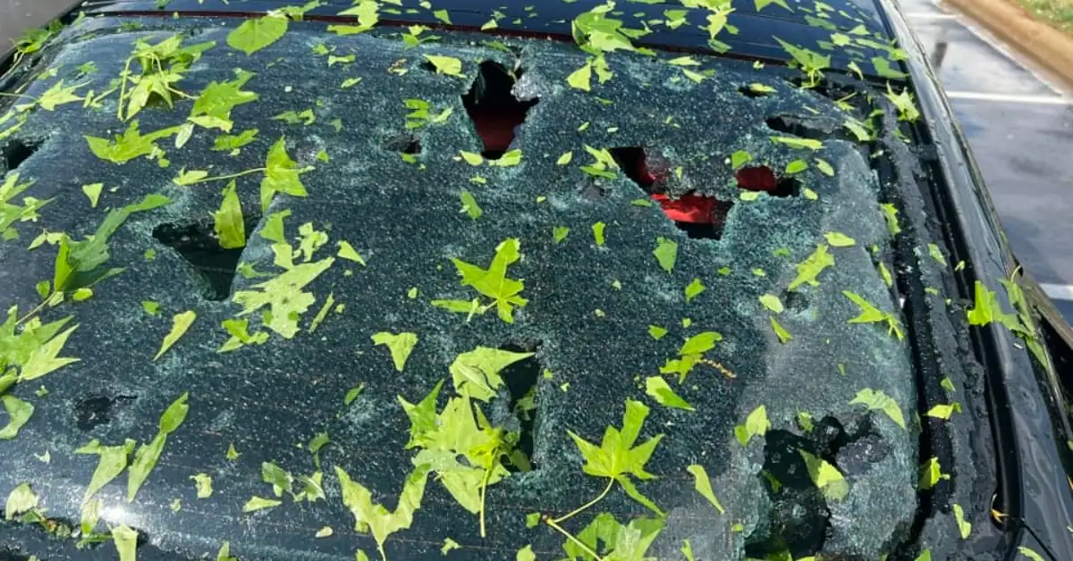
Image credit: Kimberly Dawn
A powerful storm rolled over South Carolina on April 20, 2024, bringing strong winds, heavy rain, and golf to softball-sized hail. The storm system affected the larger areas of Lancaster and York counties but focused its most intense effects in northeast-central York County, causing significant structural damage and power outages.
A powerful storm system swept through South Carolina on Saturday, causing extensive damage and power disruptions, particularly in Rock Hill, located in York County. The storm, part of a larger system that stretched from Texas across the Southeast, was marked by high winds and unusually large hail, with reports of hailstones as big as 10 cm (3.94 inches) in diameter.
Rock Hill bore the brunt of the storm, with hundreds of vehicles and buildings damaged by hail ranging from golf ball to softball size. The intensity of the storm was such that a gas station awning collapsed along SC Highway 72 just south of downtown Rock Hill. In addition to structural damages, more than 25 000 homes and businesses were left without electricity, primarily in York County, according to PowerOutage.us.
“All of a sudden, it’s hailing, it’s freezing cold outside and I couldn’t see more than five feet in front of me,” a resident told Queen City News.
Meteorologist Brad Panovich explained that the atmospheric conditions were ideally aligned for the formation of monster hail within a downburst, describing it as a perfect setup.
“The terminal velocity of golf ball size hail is around 96 km/h (60 mph), if it’s embedded in a downburst with 105 km (65 mph) winds. That means the hail is hitting cars, roofs, and homes at approximately 195 – 200 km/h (120-125 mph),” Panovich said in a Facebook post (below).
“The sound of it hitting my car was insane! Could barely see but looked baseball/softball-sized on some,” Kimberly Dawn said in a reply to Panovich.
Some local media outlets are reporting that a tornado touched down in Rock Hill, but these are unconfirmed reports and the National Weather Service (NWS) issued no tornado warning for the city (population 74 372).
The surrounding areas also felt the storm’s impact. In Gaston County, North Carolina, several trees were downed, including one that fell onto a residence along Dallas Spencer Mountain Road. Neighboring Lancaster County saw items being hurled by the winds, with local media outlets reporting damage to residential areas and commercial establishments.
Despite the severity of the storm and the widespread damage it caused, there were no injuries reported.
NWS damage survey is expected to begin on Monday, April 22.
Hailstones can vary significantly in size, often described in terms that relate them to well-known objects for clearer visual understanding.
Golf ball-sized hail measures about 4.45 cm (1.75 inches) in diameter and can begin to cause substantial damage, especially to vehicles, roofing, and siding. Slightly larger, tennis ball-sized hail has a diameter of approximately 6.35 cm (2.5 inches) and is capable of breaking windows, denting vehicles significantly, and causing serious damage to roofs and external structures.
At the larger end of the spectrum is softball-sized hail, which measures about 9.53 cm (3.75 inches) in diameter. This size of hail can penetrate roofs, smash through windows, and cause injuries to people and animals caught without protection.
Hail reaches what is considered “giant” when its diameter extends to at least 5 cm (2 inches). Such hailstones form under specific conditions within powerful thunderstorms. A critical factor in their development is the presence of a strong updraft, which is a rapidly rising air current that can keep hailstones aloft in the storm cloud.
As these hailstones circulate within the cloud, they collide with supercooled water droplets that freeze upon contact. Each collision causes the hailstones to accumulate another layer of ice, growing larger the longer they are sustained by the updraft.
In agriculture, large hail can destroy crops within minutes, wiping out entire fields and causing significant economic losses. Vehicles exposed to such hail can suffer severe damage, including significant dents and shattered windshields, potentially leading to total losses. Roofing materials of buildings may be punctured or stripped away, leading to subsequent water damage inside.
“Precipitation chances are expected to remain mostly scattered and light throughout much of the Nation into midweek as atmospheric moisture content remains sparse following the passage of a strong cold front into the Gulf of Mexico and western Atlantic,” NWS forecaster Snell noted.
A few thunderstorms are possible across the central and southern Florida Peninsula today (April 22) as the aforementioned cold front makes its final exit. A few storms could turn severe and produce damaging wind gusts and hail. Thus, the Storm Prediction Center has issued a Marginal Risk (level 1/5) for severe weather across southeast Florida. Otherwise, rain chances are forecast to progress eastward from the northern Plains to the Upper Midwest today along a swiftly moving Pacific cold front.
By Tuesday, April 23 rain chances are anticipated to stretch from the Great Lakes and Ohio Valley to the Southern Plains. The heaviest rain associated with this system is possible across parts of central/eastern Oklahoma and western Arkansas on Wednesday, April 24 but this aspect of the forecast remains somewhat uncertain.
References:
1 Saturday downpours trigger flash flooding, large hail across South – FOX Weather – April 20, 2024
2 Extensive Storm Damage in York & Gaston Counties – WCCB Charlotte – April 20, 2024
3 Short Range Forecast Discussion – NWS Weather Prediction Center College Park MD – 253 AM EDT Mon Apr 22 2024
I'm a dedicated researcher, journalist, and editor at The Watchers. With over 20 years of experience in the media industry, I specialize in hard science news, focusing on extreme weather, seismic and volcanic activity, space weather, and astronomy, including near-Earth objects and planetary defense strategies. You can reach me at teo /at/ watchers.news.
Commenting rules and guidelines
We value the thoughts and opinions of our readers and welcome healthy discussions on our website. In order to maintain a respectful and positive community, we ask that all commenters follow these rules.