
Major eruption at Ruang volcano, ash to 19.2 km (63 000 feet) a.s.l., Indonesia

Image credit: BNPB (stillshot)
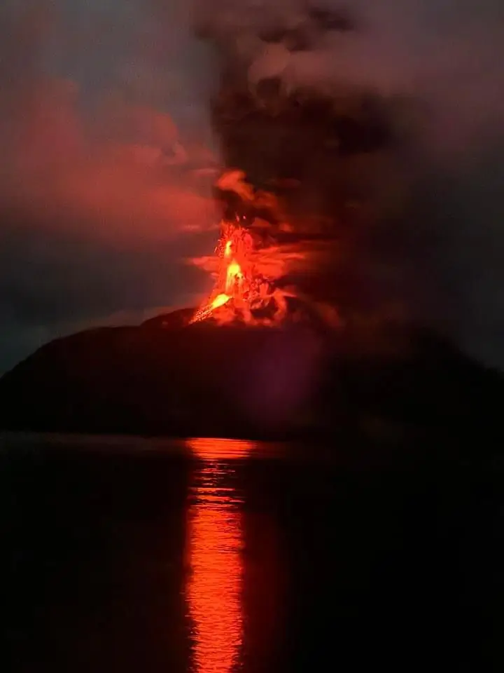
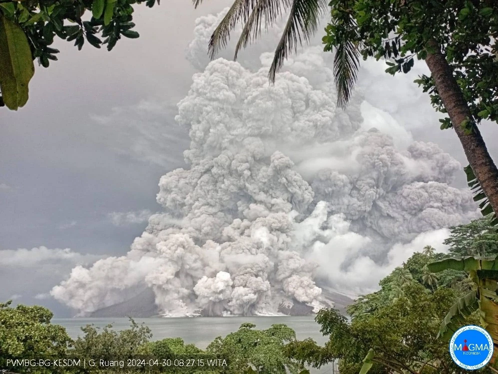
Another high-level eruption started at Indonesia’s Ruang volcano at 18:15 UTC on April 29, 2024 (01:15 LT, April 30), producing an ash column to an estimated height of about 19.2 km (63 000 feet) above sea level. Authorities raised the Alert Level to 4 and the Aviation Color Code to Red. This powerful eruption comes just 2 weeks after a similar eruption on April 16.
This intense volcanic eruption was characterized by the dramatic emission of incandescent lava that soared into the sky, illuminating it with a bright red hue. This spectacular display was further enhanced by the presence of volcanic lightning, a phenomenon associated with the eruption of ash-laden plumes into the atmosphere. Such visual manifestations are typical signs of significant volcanic activity, indicating the release of vast amounts of energy and material from within the Earth.
Concurrently, a significant shower of stones and gravel occurred, extending over a broader area than during the previous eruption on April 16. This widespread fallout is indicative of the eruption’s intensity and its capacity to disperse material over a large radius.
The Emergency Response Post, established 7 km (4.3 miles) outside the Disaster Prone Area (KRB) in Apengsala Village, was impacted by this extensive rain of stones and gravel.
The situation began to stabilize at 00:55 UTC (07:55 LT) on April 30, although rapid assessments continued to evaluate the full scope of the impact.
For safety reasons, amidst these hazardous conditions, the electricity network on Tagulandang Island has been deactivated. Additionally, the weakening of telecommunications signals has posed challenges for effective coordination and communication in the field, complicating response efforts.
The Darwin VAAC reported volcanic ash eruption to 19.2 km (63 000 feet) above sea level.
The Alert Level was raised to 4 of 4 and the Aviation Color Code to Red.
Manado’s Sam Ratulangi airport was closed at least until noon (LT) on Wednesday, May 1.
Gunungapi berjenis stratovolcano itu kembali meletus dan mengeluarkan kolom erupsi mencapai 2.000 meter dari atas puncak yang disertai suara gemuruh dan gempa yang dirasakan secara terus menerus. pic.twitter.com/N9kxmGwGXX
— BNPB Indonesia (@BNPB_Indonesia) April 30, 2024
The Ruang volcano has erupted once again.
— CIRA (@CIRA_CSU) April 29, 2024
Himawari-9 captured the moment of the explosive eruption, releasing a cloud of ash and sulfur dioxide into the atmosphere. pic.twitter.com/SbnNTNlKqw
#Ruang Some (prelim.) analyses. Q~4-5×10^9 m^3/s (2x larger than 17.04.24 eruption). 4<VEI<5. Red: 200 K contour; White dot: min Temp., Black dot: center of enclosing circle corresponding to red contour. Himawari-9 data courtesy JMA/JAXA. @simoncarn @ThomasJAubry @JAXA_en pic.twitter.com/Q6bbtn3bqp
— AIRES (@airesEO) April 30, 2024
Infrared images from @JMA_kishou #Himawari9 revealed impressive cloud-top gravity waves associated with an eruption of #Ruang in Indonesia – coldest cloud-top infrared brightness temperatures reached -90ºC (yellow pixels) immediately after eruption onset: https://t.co/4ufYO1nhkC pic.twitter.com/chTMP4W4y0
— Scott Bachmeier (@CIMSS_Satellite) April 30, 2024
Residents near Volcano Ruang, including tourists and visitors, are strongly advised to stay vigilant and avoid entering areas within a 6 km (3.7 miles) radius from the center of the active crater. This precautionary zone is established to mitigate risks from potential volcanic hazards.
For the inhabitants of Tagulandang Island located within this 6 km radius, immediate evacuation is imperative. They should relocate to safer areas beyond this specified radius to ensure their safety.
Particularly for those residing near coastal areas, there is an increased risk of hazards such as incandescent rock ejections, pyroclastic density currents (commonly known as hot clouds or surges), and potential tsunamis triggered by volcanic materials entering the sea or the collapse of parts of the volcanic structure into the ocean.
Additionally, the public is encouraged to wear masks consistently to shield themselves from volcanic ash, which poses significant health risks, particularly to the respiratory system.
Abdul Muhari, Head of BNPB Disaster Data, Information and Communication Center, urged residents to avoid succumbing to unfounded rumors regarding volcanic activity and stay informed through reliable sources—including the PVMBG (Center for Volcanology and Geological Hazard Mitigation), the Geological Agency, the National Disaster Management Authority (BNPB), local disaster management agencies (BPBD), and security forces such as TNI (National Armed Forces) and Polri (National Police).
This is the second powerful eruption at Ruang since April 16, 2024.
Most of the island’s population (800) have been evacuated after the April 16th eruption. It’s not clear how many of them have returned home and were evacuated again.
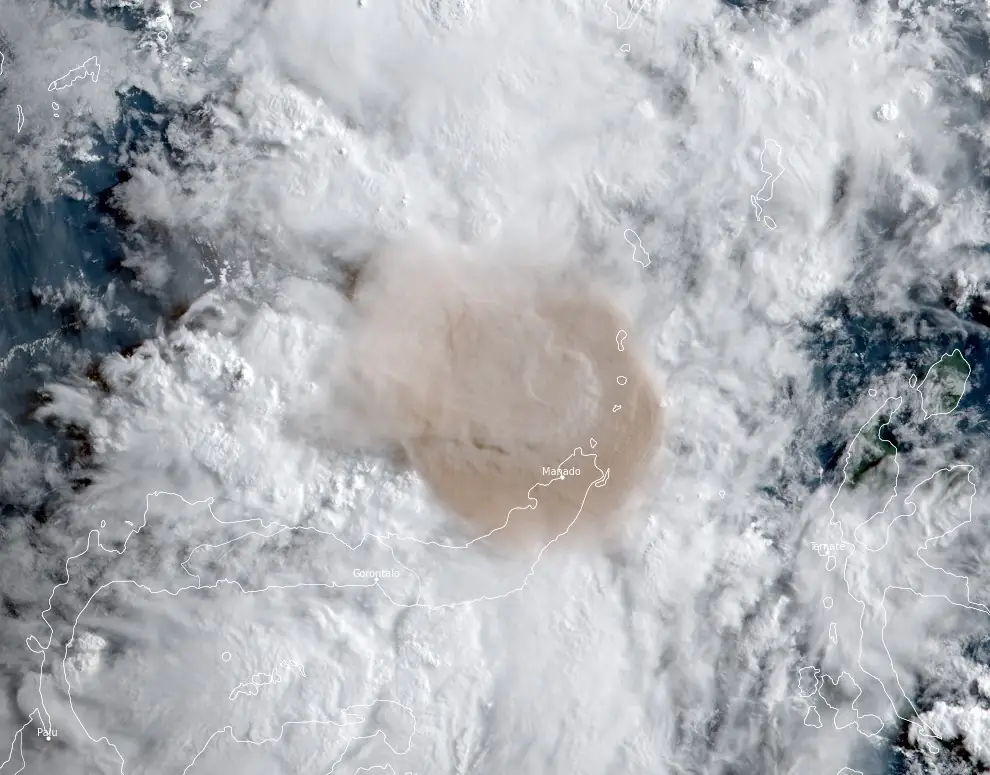
Volcanic ash [to 19.2 km / 63 000 feet a.s.l.] from the earlier high-level eruption has detached from the summit and continues to move west to southwest, the Darwin VAAC said in VA Advisory issued at 07:30 UTC on April 30.
References:
1 Gunungapi Ruang Kembali Naik Level IV ‘Awas’ – BNPB – April 30, 2024
2 Massive eruption at Ruang volcano forces mass evacuation, ash to 16.7 km (55 000 feet) a.s.l., Indonesia – The Watchers – April 17, 2024

Teo Blašković founded The Watchers in 2011 and edited it until 2026, covering seismic and volcanic activity, extreme weather, space weather and near-Earth objects. Articles on this page are his archive.
Published in the last 24 hours
- Huge waves pummel California coast during strong El Niño, flooding streets and closing piers from Pacifica to San Diego
- 2 atmospheric rivers to bring heavy Sierra snow and California flood risk
- A fireball over northern China on 6 November 2026 punched a crater into a wheat field at Beigucheng village in Hebei; the Institute of Geochemistry has now classified the fallen stones as L6 ordinary chondrites. Epicenter
- The interstellar comet 3I/ATLAS is thought to be about twice as old as Earth, and the James Webb Space Telescope has now found that its ice looks less like any comet from our own solar system than like the frozen worlds beyond Neptune, a sign it formed somewhere its star’s light could barely reach Epicenter
