
Destructive tornado outbreak strikes Nebraska and Iowa, EF2 – EF5 tornado threat continues into Sunday, U.S.

Featured image: Eppley Airport, Omaha damage after tornado on April 26, 2024. Credit: FL360aero (X)
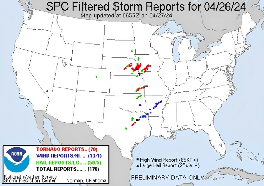
A destructive tornado outbreak with at least 78 tornadoes impacted the U.S. Plains on Friday, April 26, 2024, leaving a trail of damage and more than a dozen injuries. The outbreak occurred as a part of a multi-day severe weather threat covering over 60 million Americans. The threat of EF2 – EF5 tornadoes will continue into Sunday, April 28.
NWS SPC received 82 tornado reports — 38 tornadoes from Iowa, 33 from Nebraska, 6 from Texas, 5 from Kansas, and 4 from Missouri, making it the busiest tornado day in the United States in more than a year.
In addition, SPC received 61 large hail reports and 35 strong wind reports.
At 17:26 UTC, a tornado caused damage in the China Springs area approximately 8 km (5 miles) south of Gholson, McLennan County, Texas, with reports of tornado pictures confirming the event. By 17:28, another tornado was estimated to be on the ground for about 4 to 5 minutes near Ravenna, 3.2 km (2 miles) north-northeast in Sherman County, Nebraska, which was video confirmed.
At 17:38, Rockville, also in Sherman County, Nebraska, experienced a tornado with initial damage reports, pending further surveys. Shortly afterward, at 17:53, more tornado pictures and reports came from the area 6.4 km (4 miles) east of West, north of Tours to Penelope in McLennan County, Texas.
In Nebraska, Howard County witnessed a tornado at 17:58, 1.6 km (1 mile) south of Farwell, reported by a fireman, moving north/northeast. This was followed by another confirmed tornado at 18:14, 3.2 km (2 miles) north-northwest of Elba, with multiple reports indicating its presence west and north of Elba.
Navarro County, Texas, experienced a tornado at 18:37, 11.3 km (7 miles) south-southeast of Frost near FM 477 in the Brushie Prairie area.
Lancaster County, Nebraska, had a flurry of tornado activity starting at 19:43 near the Kawasaki Plant, 8 km (5 miles) northwest of Lincoln, followed by more near Lincoln and Waverly, with one causing significant house damage at 19:53, 1.6 km (1 mile) northwest of Waverly.
The tornado outbreak continued across Douglas, Boone, Butler, and Woodson Counties in Nebraska and Kansas, with tornadoes reported near populated areas and causing damage to houses and other structures.
Notably, at 20:43, 4.8 km (3 miles) south of New Albany, Wilson County, Kansas, a tornado was video confirmed, and by 20:45, a large tornado was moving into western Elkhorn, Douglas County, Nebraska.
Significant tornado activity was also reported in Iowa, with one report at 21:56 near Pacific Junction, Mills County, indicating a tornado on the ground.
This activity peaked with multiple homes being destroyed and significant damage near Shelby, Shelby County, Iowa, at 22:45 and 22:50.
This outbreak extended into the early hours of April 27, affecting more areas in Iowa, with a notable tornado at 01:54, 6.4 km (4 miles) northwest of Pleasant Hill, Polk County, causing structural damage to a home and potentially resulting in injuries.
A Tornado Emergency was issued for a stormcell in southwest Iowa where at least one significant tornado was produced. This tornado was on the ground for a long time, hitting several small towns on its path, storm chaser Brett Adair reported.
“Once we get into some of these more open areas where you’ve got more of the farms and the fields, in many cases, we can get lucky and not deal with so much damage. But unfortunately, this thing tracked for such a long way, we’ve seen quite a bit of damage today.”
Iowa Governor Kim Reynolds issued a disaster declaration for Pottawattamie County — home to 15 towns, including Carter Lake, Council Bluffs, Minden and Shelby.
The town of Minden (population 600), located 160 km (100 miles) W of Des Moines appears to be the worst hit.
Unfortunately, initial reports of no fatalities from these storms changed on Saturday after we learned that a man in Minden ended up trapped in his basement when a massive twister ripped through the area. Despite being rushed to a hospital for treatment, he succumbed to his injuries on Saturday.
Extensive damage, with multiple homes damaged, was reported in nearby Shelby County, IA.
I have approved a Proclamation of Disaster Emergency for Pottawatamie County to support storm recovery efforts in Minden.
— Gov. Kim Reynolds (@IAGovernor) April 27, 2024
Continuing to monitor the storm and the situation. https://t.co/TwXScKa3sy
NWS office in Omaha, NE issued 42 Tornado Warnings, a rare Tornado Emergency, and 25 Severe Thunderstorms as a violent supercell rolled over eastern parts of the state.
One of the tornadoes in Nebraska knocked over part of a train and hit a Kawasaki Plant with at least 70 workers inside. Lancaster County Sherrif’s Office reported several workers trapped, but only three had non-life-threatening injuries.
In Elkhorn, a suburb of Omaha, rescue teams are currently sifting through debris following a very large tornado that destroyed numerous homes and left the community with severe infrastructural damage, including power outages, gas leaks, and fallen trees.
During a recent press conference, local authorities reported that two individuals sustained minor injuries and were taken for medical care. Omaha Police Chief Todd Schmaderer attributed the minimal injuries to effective local warning systems that provided advance notice of the storm, thus saving lives.
Storm chaser Thomas Hinterdorfer described the aftermath as a “very devastating situation,” noting that some homes were completely obliterated while many others incurred major damage, pointing towards an extended recovery period.
Omaha’s Eppley Airfield was temporarily shut down for damage assessment after it was hit by a tornado at 17:08 LT. According to the airport’s Chief Operations Officer Tim Schmitt, the closure lasted about an hour, allowing for checks after some planes and hangars sustained damage. The airport had taken precautionary measures by moving passengers to storm shelters, resulting in no injuries.
More on the destruction at the Eppley Airfield (OMA), Omaha, Nebraska after a massive tornado hit the premises and the area.
— FL360aero (@fl360aero) April 27, 2024
Eppley Airport says, Passenger terminal was unaffected while a number of buildings and properties of General Aviation terminal sustained damage.
Video… pic.twitter.com/69eO2mChFU
Additionally, a train derailment occurred near Waverly, Nebraska, when a tornado struck, leading to significant disruptions. Burlington Northern Santa Fe railway staff were actively working to clear the derailment site on Friday.
Severe weather is forecasted to persist into the weekend, with Saturday, April 27 marked as potentially the most dangerous day. More than 50 million people are at risk today.
The severe storm threat spans a wide area from Michigan to Texas, affecting major cities including Oklahoma City, Kansas City, Dallas, Milwaukee, Chicago, and Austin. These storms could bring damaging winds, large hail up to baseball size, and strong tornadoes.
Areas in southeastern Nebraska, southern Iowa, eastern Kansas, and northeastern Texas, already impacted on Friday, may face renewed severe conditions.
This weather pattern is driven by moist air from the Gulf of Mexico and increasing heat in the central U.S., creating ideal conditions for continued severe storms. Cities like Dallas, Kansas City, Des Moines, and Omaha might experience multiple severe thunderstorm events through Sunday.
The Storm Prediction Center (SPC) has issued an Enhanced Risk (level 3/5) for severe thunderstorms across the Middle Mississippi Valley and Central/Southern Plains extending into Sunday morning. The primary hazards include frequent lightning, severe wind gusts, hail, and a few tornadoes, with a heightened possibility of EF2 – EF5 tornadoes and hail exceeding 5 cm (2 inches) in diameter within the region.
Additionally, heavy rainfall associated with these storms has led the Weather Prediction Center (WPC) to issue a Moderate Risk (level 3/4) for excessive rainfall over similar areas. This is expected to result in widespread flash flooding and potential flooding of streams that may impact larger rivers.
By Sunday, the threat of excessive rainfall is projected to diminish slightly; therefore, the WPC has issued a Slight Risk (level 2/4) of excessive rainfall for the Middle/Lower Mississippi Valley and Southern Plains. The forecast anticipates primarily localized flash flooding, particularly affecting urban zones, roads, small streams, and low-lying areas.
The risk for severe thunderstorms is also expected to decrease on Sunday. The SPC has updated the risk level to Slight (level 2/5) for the Middle/Lower Mississippi Valley and Central/Southern Plains, with anticipated threats including frequent lightning, severe thunderstorm wind gusts, hail, and a few tornadoes.
References:
1 NWS/SPC – Filtered storm reports for April 26, 2024 – 05:55 UTC, April 27
2 Catastrophic tornado damage reported in Plains as additional rounds of severe storms expected over weekend – FOX Weather – April 27, 2024
3 Catastrophic destruction in wake of massive tornadoes in Nebraska, Iowa – AccuWeather – April 27, 2024
4 Short Range Forecast Discussion – NWS Weather Prediction Center College Park MD – 402 PM EDT Fri Apr 26 2024
I'm a dedicated researcher, journalist, and editor at The Watchers. With over 20 years of experience in the media industry, I specialize in hard science news, focusing on extreme weather, seismic and volcanic activity, space weather, and astronomy, including near-Earth objects and planetary defense strategies. You can reach me at teo /at/ watchers.news.
Commenting rules and guidelines
We value the thoughts and opinions of our readers and welcome healthy discussions on our website. In order to maintain a respectful and positive community, we ask that all commenters follow these rules.