
Severe storms unleash tornadoes and extreme floods across Texas and Louisiana, U.S.
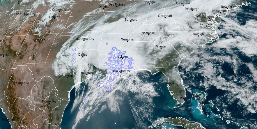
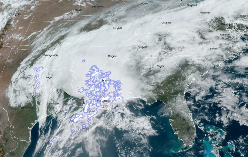
Image credit: NOAA/GOES-East, RAMMB/CIRA, The Watchers. Acquired at 15:00 UTC on April 10, 2024
A deadly severe weather outbreak hit the Gulf Coast and lower Mississippi Valley on April 10, 2024, with tornadoes, heavy rains, and high wind gusts. The storms caused at least one fatality in Mississippi and widespread destruction, including in New Orleans, which faced a Flash Flood Emergency. Investigations suggest the event might qualify as a serial derecho — a significant meteorological phenomenon.
In a severe weather outbreak that spanned across the Gulf Coast and lower Mississippi Valley on April 10, 2024, at least one person was killed, and numerous others were injured. The city of New Orleans, particularly affected by the storms, faced a Flash Flood Emergency as torrential rains led to widespread flooding, making many roads and underpasses impassable.
The National Weather Service reported that New Orleans International Airport recorded 158.8 mm (6.24 inches) of rainfall in just seven hours, marking the third-highest rainfall for April in the region’s history.
Alongside the floods, the region experienced powerful wind gusts, with one reaching up to 114 km/h (71 mph) east of New Orleans.
In Slidell, Louisiana, an EF-2 tornado caused significant damage, leading to the injury of several people within a heavily impacted apartment building.
Local officials reported that hundreds of homes and businesses suffered damage, with over 100 000 residents experiencing power outages.
Mississippi also faced severe impacts, with one fatality reported in Scott County and additional injuries across the state. Emergency services were on high alert for a potential levee break in Yazoo County, prompting evacuations for safety.
In Texas, a preliminary EF-1 tornado caused destruction in Katy, while in Chunchula, Alabama, another tornado damaged a home.
Additionally, southeastern Texas saw over 203 mm (8 inches) of rain within 24 hours, leading to Flash Flood Emergencies and numerous rescues.
The FOX Weather Center suggests that the widespread damage and wind reports from Houston to the Florida Panhandle could classify this event as a serial derecho, a rare and powerful type of windstorm. As the storm system moved eastward, it continued to cause significant flooding and damage across the Gulf Coast.
Serial derechos are produced by multiple bow echoes embedded in an extensive squall line that sweeps across a very large area, both wide and long. This type of derecho is typically associated with a strong upper level trough with a strong surface low pressure system.
While the affected region continues to grapple with the aftermath of this severe weather outbreak, the National Weather Service (NWS) forecasts a powerful low pressure system to affect parts of the Great Lakes, Ohio Valley, and Northeast through Friday, April 12. This system is expected to bring gusty winds and heavy rain, potentially impacting recovery efforts and leading to further weather-related challenges.
The Midwest and Northeast will see a continuation of showers and thunderstorms into Friday due to a deep cyclone over the Great Lakes gradually moving into Canada. While showers are predicted to decrease from west to east across the Great Lakes and Ohio Valley as the cyclone departs, moderate to heavy rainfall is likely to persist along the Appalachians into the Lower Great Lakes.
The trailing cold front is set to bring the heaviest rainfall through New England, where moist southeasterly flow off the Atlantic and upslope conditions along the northern Appalachians may enhance storm intensity and rain totals. Particularly, parts of New Hampshire and Maine face a Slight Risk of Excessive Rainfall (level 2/4), with concerns over flooding exacerbated by the combination of heavy rain and snowmelt. Some lighter, lingering showers might continue into Saturday, mainly affecting the interior Northeast, while windy conditions are forecast across the Great Lakes, Appalachians, and New England with Wind Advisories in place.
Meanwhile, the West is bracing for its own set of weather events as a frontal system moving southward brings lower-elevation rain showers and higher-elevation snow showers to the northern Great Basin and Pacific Northwest on Friday. An approaching Pacific system is expected to increase precipitation chances in California from late Friday into Saturday, April 13, potentially causing moderate to heavy showers along the coast and accumulating snowfall across the Northern Coastal Ranges, Klamath Mountains, and Sierra Nevada.
The southern Sierra may receive 15 – 30 cm (6 – 12 inches) of snow, with Winter Weather Advisories issued and gusty winds anticipated, particularly along the mountain ranges.
Temperature-wise, the Lower Great Lakes, Ohio Valley, and Tennessee Valley will experience cooler, below-average temperatures following a recent cold front passage, extending into the Northeast and Mid-Atlantic by Saturday. Although the Southeast and Florida will see temperatures around or just below average, a significant temperature surge is forecast for the northern and central Plains this weekend, where highs could reach into the 80s (~27 – 30 °C), marking temperatures 20 – 25 °F (11 – 14 °C) above normal.
This warm spell is attributed to upper-level ridging moving eastward over the central U.S. However, California is expected to cool down on Saturday as the Pacific system moves inland, offering a brief respite from the heat.
References:
1 Deadly severe weather outbreak slams New Orleans with flash flooding, tornadoes across South – FOX Weather – April 11, 2024
2 Short Range Forecast Discussion – NWS Weather Prediction Center College Park MD – 356 AM EDT Fri Apr 12 2024
I'm a dedicated researcher, journalist, and editor at The Watchers. With over 20 years of experience in the media industry, I specialize in hard science news, focusing on extreme weather, seismic and volcanic activity, space weather, and astronomy, including near-Earth objects and planetary defense strategies. You can reach me at teo /at/ watchers.news.
Commenting rules and guidelines
We value the thoughts and opinions of our readers and welcome healthy discussions on our website. In order to maintain a respectful and positive community, we ask that all commenters follow these rules.