
Florida and Georgia brace for severe thunderstorms and heavy rainfall
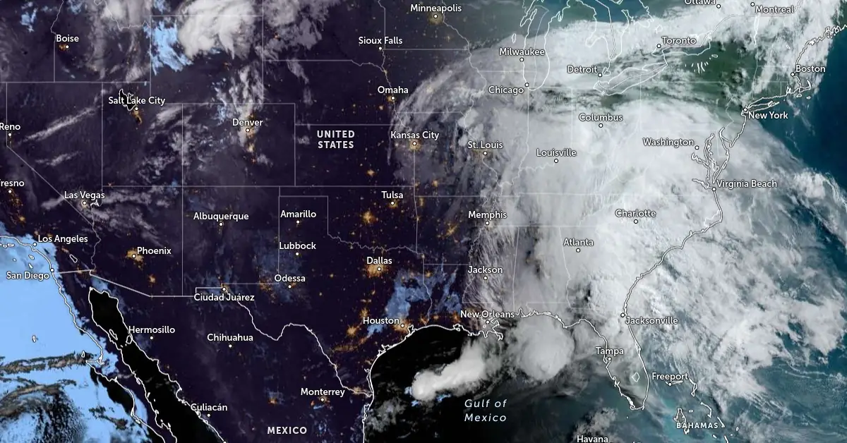
Image credit: NOAA/GOES-East, Zoom Earth, The Watchers. Acquired at 12:00 UTC on May 14, 2024
Strong to severe thunderstorms are expected to move east on May 14, 2024, affecting northern Florida and southern Georgia with damaging winds and heavy rainfall. Additionally, heavy to excessive rainfall is expected over northern Florida, potentially leading to flash flooding.
A slow-moving frontal boundary is causing wet and unsettled weather along the Gulf Coast and Southeast today, May 14. Showers and thunderstorms in this region have the potential to become severe, with the Storm Prediction Center (SPC) issuing a Slight Risk warning for severe weather. This indicates the possibility of multiple corridors of damaging winds, very large hail, and one or two tornadoes across central and northern Florida and southern Georgia.
The Weather Prediction Center (WPC) has also highlighted a Slight Risk for excessive rainfall and local flash flooding in the same areas. A broader Marginal Risk extends northward to the Ohio Valley and Mid-Atlantic regions. As the system progresses eastward, the threat level for severe storms and heavy rainfall will diminish to a Marginal Risk on Wednesday.
Showers and thunderstorms will spread from the lower Missouri and mid-Mississippi valleys to the Ohio Valley and further east to the Mid-Atlantic and Northeast regions today. A brief period of drier weather is expected over the Mississippi Valley early Wednesday, followed by another round of showers and storms later in the day.
Meanwhile, the Northern Rockies into Central Rockies and High Plains will experience showers and storms, followed by much cooler temperatures on Tuesday. South Florida will continue to experience well above-normal, near-record high temperatures through Wednesday. Warmer temperatures will also spread across the western states, reaching well-above normal highs by midweek.
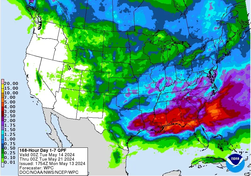
Additionally, the NWS Weather Prediction Center warns that another wave of heavy rainfall is forecast to impact parts of eastern Texas and the Lower Mississippi Valley later this week, and rain falling on saturated soils will likely cause additional flash flooding.
There is a Moderate Risk of Excessive Rainfall on Thursday-Thursday night from east Texas through central Louisiana to far western Mississippi where the risk of flash flooding will be highest.
References:
1 Short Range Forecast Discussion – NWS WPC – 348 AM EDT Tue May 14 2024

Teo Blašković founded The Watchers in 2011 and edited it until 2026, covering seismic and volcanic activity, extreme weather, space weather and near-Earth objects. Articles on this page are his archive.
Earlier reporting
Nothing on Watchers was published in the last 24 hours. These are older articles.
- 2 atmospheric rivers to bring heavy Sierra snow and California flood risk
- CPC posts a slight risk of heavy rain from the Gulf Coast to the Northeast urban corridor November 25-29, and a moderate risk of West Coast wind and Sierra snow on November 25
- The storms drenching California this week are fed by a river in the sky, a band of water vapor that can carry up to 15 times the flow of the Mississippi River, and this winter’s near-record El Niño could keep aiming more of them at the West Coast
- Atmospheric river brings moderate risk of heavy rain, mountain snow and high winds to northern California and southwest Oregon on November 24-25
