
Intense Tropical Cyclone Gezani makes landfall near Toamasina on Madagascar’s east coast
Intense Tropical Cyclone Gezani struck eastern Madagascar near Toamasina at approximately 16:00 UTC on February 10, 2026, with maximum sustained winds estimated near 175 km/h (109 mph) at landfall. The cyclone produced hurricane-force winds, storm surge, and widespread heavy rainfall before beginning to weaken inland.

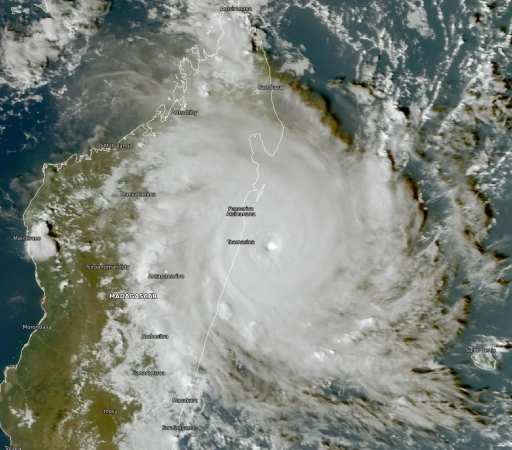
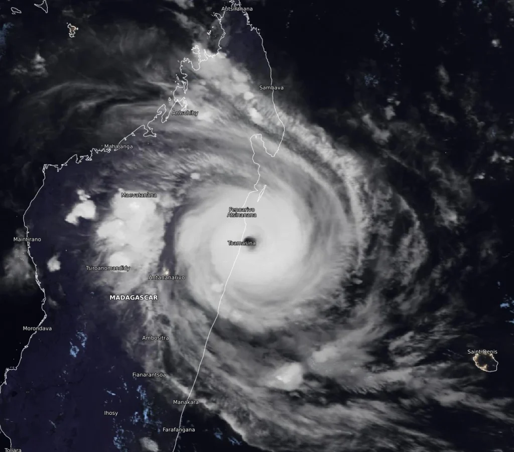
Satellite image of Tropical Cyclone Gezani at 16:40 UTC on February 10, 2026. Credit: EUMETSAT/Meteosat, The Watchers
Intense Tropical Cyclone Gezani made landfall on the east coast of Madagascar near Toamasina, a city with an estimated urban population of about 575 000, at around 16:00 UTC (19:00 local time) on Tuesday, February 10, according to the Regional Specialized Meteorological Centre in La Réunion.
At the time of landfall, maximum 10-minute sustained winds were estimated at around 175 km/h (109 mph), with a minimum central pressure near 955 hPa. Such wind speeds are sufficient to cause severe wind damage, particularly in exposed coastal areas.
Satellite and infrared imagery showed rapid deterioration of the cyclone’s eye structure as the circulation interacted with land, but hurricane-force winds likely persisted for several hours in and near the landfall area during the late afternoon and evening.
Rainfall accumulations of 150–200 mm (6–8 inches) were expected within 12 to 24 hours across much of the impacted region, with local totals possibly reaching 300–400 mm (12–16 inches) over higher terrain inland from the coast, posing a high risk of flash flooding and landslides, particularly in elevated and flood-prone areas.
The National Office for Risk and Disaster Management placed Analanjirofo and Atsinanana under Red alert ahead of landfall, while several other regions, including Alaotra Mangoro, Analamanga, Betsiboka, Bongolava, Itasy, Vakinankaratra, Melaky, Menabe, Andapa, Mandritsara, Befandriana, and Avaratra, were placed under Yellow alert.
School classes were suspended on February 11 in some regions, including Analamanga, as authorities implemented safety measures.
Significant wave heights of 6–10 m (20–33 feet) were reported offshore, while storm surge of 2–3 m (6.5–10 feet) was expected along exposed sections of the coast during the evening. Marine conditions were forecast to improve overnight as the cyclone weakened over land and moved farther inland.
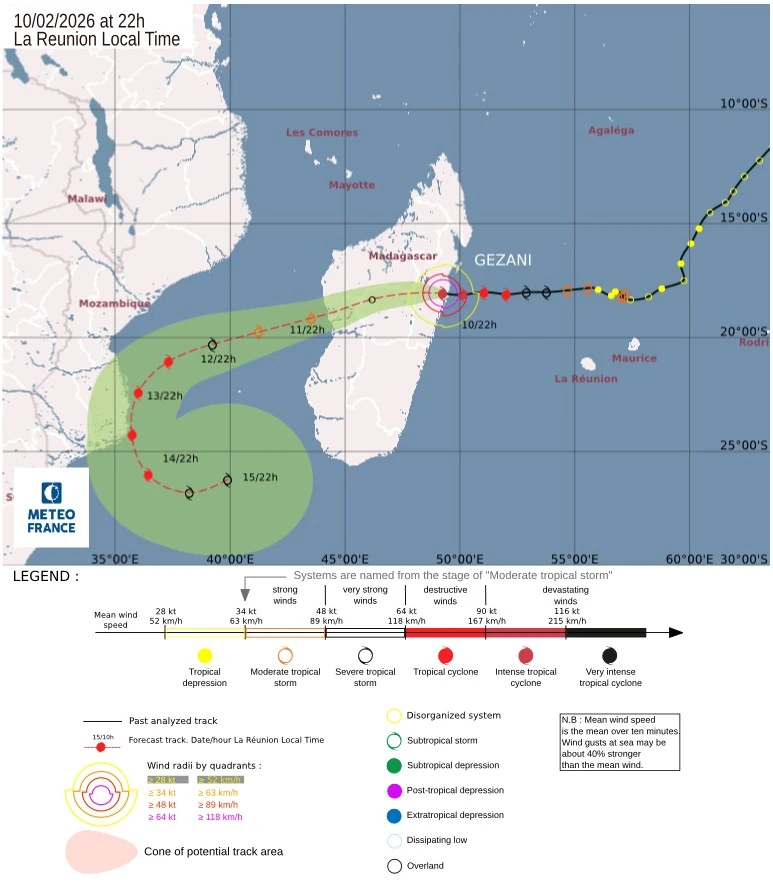
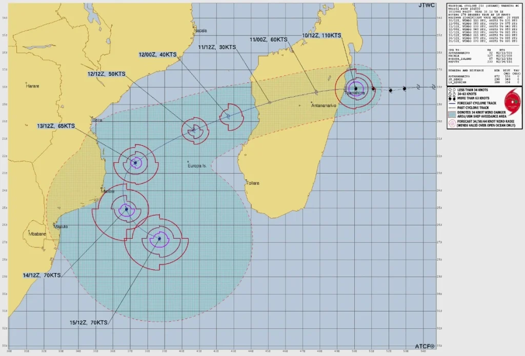
As Gezani continues westward across Madagascar, interaction with the island’s rugged terrain is expected to further disrupt the low-level circulation. The system is forecast to weaken to a tropical depression or tropical storm within the next 24 hours while crossing the island from east to west.
According to the official forecast, the cyclone is expected to re-emerge over the Mozambique Channel by Wednesday evening, February 11, approximately 150 km (93 miles) north of Morondava.
Environmental conditions over the channel may again become favorable for re-intensification, although track and intensity uncertainty increase later in the forecast period due to evolving steering influences.
Gezani is the 8th named storm of the 2025/26 South-West Indian Ocean cyclone season.
It comes just ten days after Tropical Cyclone Fytia impacted Madagascar, leaving at least 12 people dead. More than 31 000 people were displaced and over 200 000 affected across nine regions. Nearly 18 600 houses were flooded, damaged, or destroyed, along with 493 classrooms and 20 health facilities.
Read more:
References:
1 Intense Tropical Cyclone 10 (Gezani) – RSMC La Reunion – Issued at 18:00 UTC on February 10, 2026
2 Cyclone Gezani Prognostic Reasoning – JTWC – Issued at 15:00 UTC on February 10, 2026
3 Madagascar: Humanitarian impact of Tropical Cyclone Gezani Flash Update No. 1 – UN OCHA – February 10, 2026

I am an Assistant Editor and Severe Weather & Science Journalist at The Watchers, specializing in real-time severe weather coverage, geophysical event reporting, and research-driven scientific analysis. You can reach me at rishav(at)watchers(.)news.
Commenting rules and guidelines
We value the thoughts and opinions of our readers and welcome healthy discussions on our website. In order to maintain a respectful and positive community, we ask that all commenters follow these rules.