
Tropical Cyclone Horacio becomes strongest storm of 2026 east of Mauritius
Tropical Cyclone Horacio intensified to a Category 5-equivalent system over the central Southwest Indian Ocean east of Mauritius on February 22, 2026, becoming the strongest tropical cyclone recorded globally this year. The storm reached sustained winds near 260 km/h (160 mph) before moving southward over open waters.

Satellite image of Tropical Cyclone Horacio at 04:00 UTC on February 24, 2026. Credit: EUMETSAT/Meteosat-9, RAMMB/CIRA, The Watchers
Tropical Cyclone Horacio developed from a low-pressure disturbance east of Rodrigues Island on February 18 and was named by the Regional Specialized Meteorological Centre (RSMC) La Réunion the following day. Within 48 hours, it underwent rapid intensification over warm waters with favorable upper-level outflow, reaching a very intense status by February 22.
At its peak between February 22 and 23, RSMC La Réunion estimated 10-minute sustained winds around 230 to 240 km/h (140 to 150 mph) and gusts near 280 to 300 km/h (175 to 185 mph) with a central pressure of approximately 910 hPa.
The Joint Typhoon Warning Center (JTWC) concurrently assessed 1-minute sustained winds of about 260 km/h (160 mph), placing Horacio at a Category 5 equivalent cyclone on the Saffir-Simpson scale and the strongest tropical cyclone recorded globally so far in 2026.
The cyclone tracked south-southwestward east of Mauritius before turning south across the open Indian Ocean.
Outer rainbands brought periods of rain and strong gusts to Rodrigues Island, where winds reached around 100 km/h (60 mph), and seas exceeded 6 to 8 m (20 to 26 feet).
Mauritius Meteorological Services (MMS) maintained a Class 1 Cyclone Warning until February 23, then lifted it as the system moved away. No major damage or casualties were reported.
MMS issued a Heavy Swell Warning for Rodrigues at 04:30 LT (00:30 UTC) on February 24, valid until 04:00 LT (00:00 UTC) on February 25.
“High-energy swells generated by the Intense Tropical Cyclone Horacio are influencing the sea state around Rodrigues. The sea will be high with swells of 7 m (23 feet) beyond the reefs. The waves will also influence the lagoons and may break along the low-lying coastal areas, especially during high tides.”
Fishermen, pleasure-craft operators, and the public were strongly advised not to venture at sea or along beaches while the warning remained in effect.
At 06:00 UTC on February 24, Horacio’s center was about 315 km (196 miles) southeast of Rodrigues, continuing south while weakening.
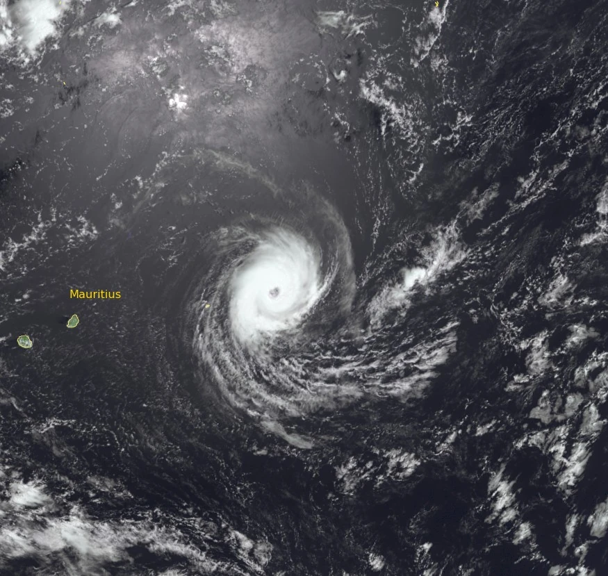
At the height of its development, Horacio exhibited a symmetrical eye structure and strong convective bands clearly visible in Himawari-8 imagery.
RSMC La Réunion classified it as a “Very Intense Tropical Cyclone,” the highest rating in the Southwest Indian Ocean basin. Such classification is rare and typically occurs once or twice per season.
The event coincided with the climatological peak of the Southern Hemisphere cyclone season (February to March), when sea-surface temperatures and monsoonal outflow patterns favor rapid intensification.
Horacio is forecast to continue weakening and transition into a post-tropical system within 48 hours while moving southward over open waters.
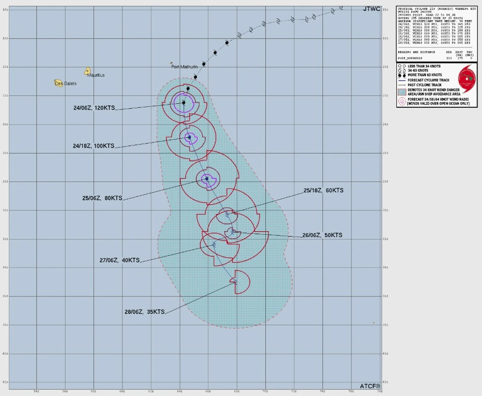
“Regarding the intensity forecast, environmental conditions will gradually deteriorate, with increasing vertical wind shear partially offset by strong upper-level divergence and an outflow channel to the southeast,” meteorologists at the RSMC La Réunion noted at 07:32 UTC on February 24.
“The system is expected to weaken progressively. By Wednesday, under the influence of strong northwesterly shear on the western edge of the trough, Horacio could begin to lose some of its tropical characteristics. Oceanic heat potential will also decline, leading to reduced convective activity. Although a temporary decrease in shear is expected on Friday, re-intensification is unlikely due to colder surface waters. The cyclone should continue to weaken through the weekend, transitioning into an extra-tropical depression.”
This is the 9th named storm of the 2025/26 Southwest Indian Ocean cyclone season.
References:
1 Intense Tropical Cyclone 11 (Horacio) Warning Number: 21/11/20252026 – RSMC La Réunion – Issued at 07:32 UTC on February 24, 2026
2 Heavy Swell Warning Bulletin – Mauritius Meteorological Services – Issued at 00:30 UTC on February 24, 2026
I'm a dedicated researcher, journalist, and editor at The Watchers. With over 20 years of experience in the media industry, I specialize in hard science news, focusing on extreme weather, seismic and volcanic activity, space weather, and astronomy, including near-Earth objects and planetary defense strategies. You can reach me at teo /at/ watchers.news.
Commenting rules and guidelines
We value the thoughts and opinions of our readers and welcome healthy discussions on our website. In order to maintain a respectful and positive community, we ask that all commenters follow these rules.