
Gezani forecast to reach intense tropical cyclone strength near Mozambique coast, more than 1 million at risk
Tropical Cyclone Gezani was located in the Mozambique Channel at 12:00 UTC on February 12, 2026, with maximum sustained winds of 120 km/h (75 mph) and is forecast to intensify to 165 km/h (105 mph) near the Mozambique coast by February 14. Gale- to hurricane-force winds, rainfall totals locally reaching 200 mm (8 inches), and high seas of 7–10 m (23–33 feet) are possible in Inhambane Province, while Sofala and Gaza provinces remain saturated from prolonged flooding that has already displaced hundreds of thousands.

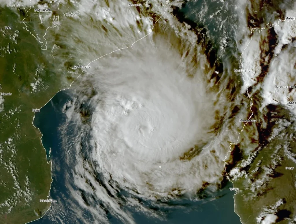
Satellite image of Tropical Cyclone Gezani at 14:50 UTC on February 12, 2026. Credit: EUMETSAT/Meteosat, The Watchers
Tropical Cyclone Gezani was located approximately 530 km (330 miles) east-northeast of Beira, Mozambique, and about 690 km (430 miles) west of Toamasina, Madagascar, at 12:00 UTC on February 12, according to the Regional Specialized Meteorological Center (RSMC) La Réunion.
The system was moving west-southwest at 20 km/h (12 mph), toward Mozambique, with maximum sustained winds of 120 km/h (75 mph) and a central pressure of 983 hPa. Satellite analysis indicated a developing eye configuration and a deep vertical circulation.
Forecast guidance from RSMC indicates steady intensification over the next 36 hours, with winds expected to reach 165 km/h (105 mph) by 00:00 UTC on February 14. At that stage, Gezani would be classified as an intense tropical cyclone under Southwest Indian Ocean standards.
The forecast track keeps the system moving west-southwest toward the Mozambique coastline through February 13 before turning south and later east under the influence of an approaching upper-level trough.
While a definitive landfall remains uncertain, forecasters state that a very close coastal passage or temporary partial landfall cannot be ruled out.
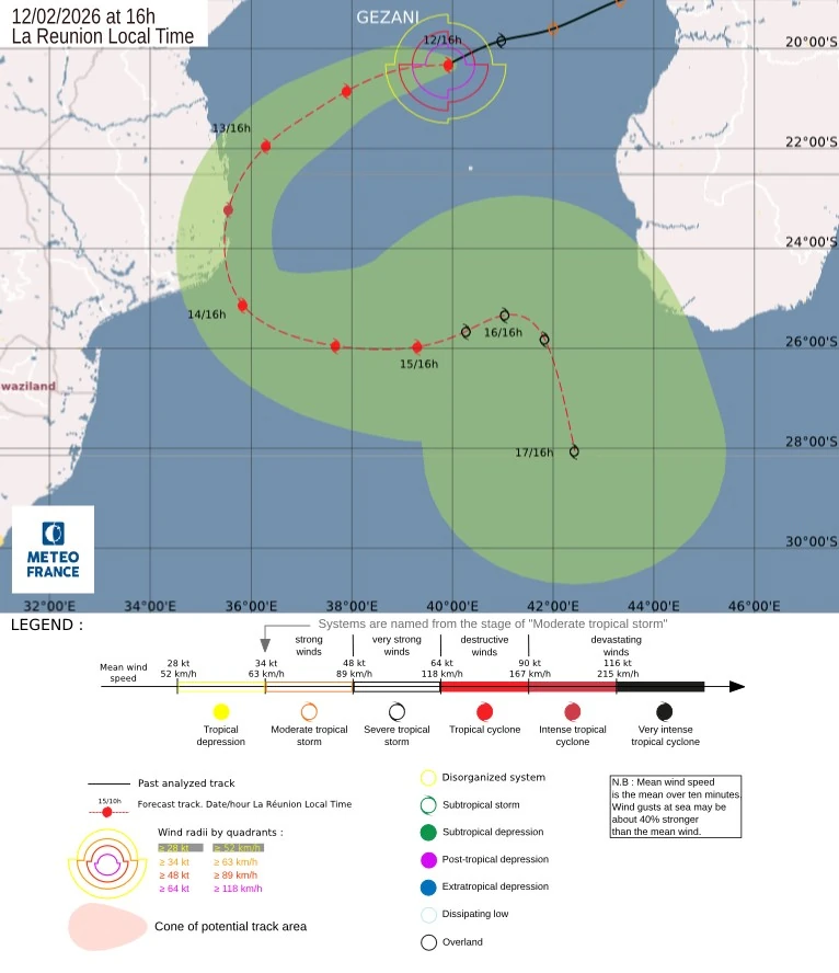
Expected impacts in Inhambane Province, Mozambique, include gale-force winds beginning Friday evening, February 13, with storm-force winds likely and hurricane-force winds possible during the night into early February 14.
Heavy rainfall along the coast of Mozambique is forecast from Friday night through Saturday afternoon, with totals near 100 mm (4 inches) in less than 24 hours near the coast and locally 200 mm (8 inches) at the point of closest approach. This is sufficient to trigger renewed flooding in the region, given current soil saturation and elevated river levels.
Waves are expected to exceed 4 m (13 feet) beginning Friday afternoon, with temporary peaks between 7–10 m (23–33 feet) Friday night into Saturday morning. Localized storm surge near 50 cm (1.6 feet) is possible along exposed coastal sections.
Gezani impacted Madagascar between February 10 and 12, resulting in at least 35 fatalities and widespread structural damage in Toamasina.
According to the National Bureau for Risk and Disaster Management (BNGRC), around 80% of the city’s infrastructure had been damaged or destroyed. The cyclone’s aftermath displaced another 6 870 people, while a total of 250 406 were classified as disaster victims, the BNGRC said.
The system retained a well-defined circulation after emerging into the Mozambique Channel, where high ocean heat content and low vertical wind shear are supporting renewed strengthening.
Mozambique is already facing severe hydrological stress following consecutive weeks of heavy rainfall.
The National Institute for Disaster Management and Risk Reduction reported on February 5 that 723 500 people were affected nationwide, including 392 000 displaced after homes were flooded or destroyed. Critical infrastructure, including health facilities, schools, and road networks, has sustained extensive damage, limiting access to several districts.
Local reports say more than 1 million people could be affected if Gezani impacts Sofala, Gaza, and Inhambane provinces. Even without a direct landfall, strong winds and outer rainbands may produce flooding rainfall across areas that remain saturated.
February falls within the climatological peak of the Southwest Indian Ocean tropical cyclone season. While the timing of Gezani is consistent with seasonal norms, the current vulnerability of flood-affected communities increases the likelihood of disproportionate impacts from additional rainfall and wind exposure.
Uncertainty in the track forecast remains elevated beyond February 15, particularly regarding the degree of interaction with Mozambique’s landmass. RSMC indicates that the convective core may not penetrate far inland even in a close-pass scenario, which would limit rapid weakening and prolong coastal impacts.
Gezani is the 8th named storm of the 2025/26 Southwest Indian Ocean cyclone season.
References:
1 Tropical Cyclone 10 (Gezani) – RSMC La Reunion – Bulletin issued at 12:00 UTC on February 12, 2026
2 Oxfam warning of ‘disaster upon disaster’ as Mozambique braces for Tropical Storm Gezani –Oxfam – February 12, 2026
I'm a dedicated researcher, journalist, and editor at The Watchers. With over 20 years of experience in the media industry, I specialize in hard science news, focusing on extreme weather, seismic and volcanic activity, space weather, and astronomy, including near-Earth objects and planetary defense strategies. You can reach me at teo /at/ watchers.news.
Commenting rules and guidelines
We value the thoughts and opinions of our readers and welcome healthy discussions on our website. In order to maintain a respectful and positive community, we ask that all commenters follow these rules.