
At least 12 dead, 2 000 homes destroyed as Tropical Cyclone Fytia hits Madagascar
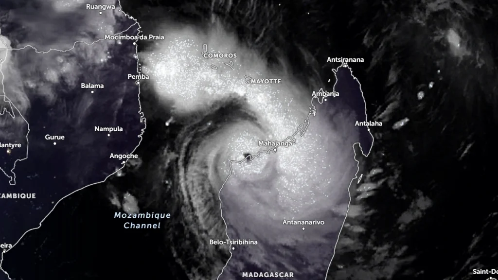
At least 12 people were killed and more than 77 000 affected after Tropical Cyclone Fytia struck northwestern Madagascar at 01:40 UTC on January 31, 2026. Winds of 185 km/h (115 mph) and intense rainfall caused severe damage across 35 districts, with Soalala and Mitsinjo among the hardest hit. Fytia is the 7th named storm of the 2025/26 South-West Indian Ocean cyclone season.
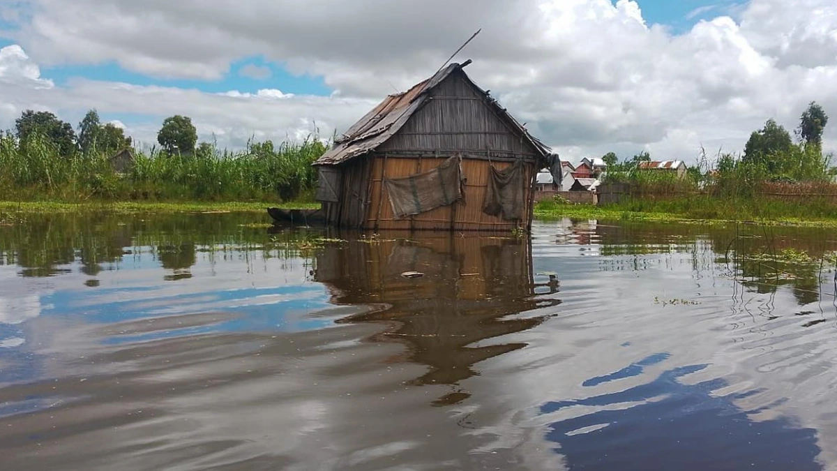
Flooding in Madagascar due to Severe Tropical Cyclone Fytia's landfall on January 31, 2026. Credit: BNGRC
Tropical Cyclone Fytia formed over the Mozambique Channel on January 30 and made landfall at Soalala in northwestern Madagascar at around 01:40 UTC on January 31. It then tracked southeast over the southern Indian Ocean on February 2 and 3, weakening after crossing Madagascar.
The storm made landfall with an estimated minimum central pressure of 962 hPa. Maximum sustained winds near the center reached over 185 km/h (115 mph), with gusts of up to 210 km/h (131 mph), making it a Category 3-equivalent cyclone.
It then moved east-southeast across central and eastern regions until February 1, bringing intense rainfall and damaging winds to multiple regions.
A total of 35 districts in nine regions were affected by the cyclone, including Analamanga, Atsinanana, Vakinankaratra, Boeny, Betsiboka, Melaky, Sofia, Alaotra Mangoro, and Itasy. Soalala and Mitsinjo districts in the Boeny region were the worst hit. Access is currently limited to air transport due to flooded and damaged roads.
At least 12 people were confirmed dead, while seven others were injured. Over 77 000 people were affected by the cyclone, and nearly 31 000 displaced.
Over 18 500 homes were affected by the cyclone, including 13 500 homes that were flooded, according to the National Disaster Risk Management Office (BNGRC).
At least 1 950 homes were completely destroyed, while 2 211 homes were partially damaged. A total of 282 schools and public buildings were also affected, including 54 completely destroyed, 133 damaged, and 94 partially damaged.
Water levels in the Sisaony rose rapidly on Sunday and were expected to continue rising throughout Monday. Authorities have warned of a high risk of flooding from a weakened dyke on the Sisaony River in the plains around the capital, which has been weakened by heavy rainfall in recent weeks.
Mozambique, which is currently at the peak of the 2025/26 rainy and cyclone season, was also impacted by Fytia. The cyclone brought heavy to very heavy rainfall to parts of the country, severe thunderstorms, and flooding, compounding conflict-related displacement.
“Communities in Nampula were already severely affected by last year’s cyclones and the current flooding and do not have the systems, services, or resources needed to support those who are newly displaced,” said Mozambique Country Director Katia dos Santos Dias.
In response to escalating risks, the government has activated a nationwide red alert, including compulsory evacuations in high-risk flood zones.
Floods have affected much of Mozambique since last year, with over 600 000 people across the country affected by heavy rains that began on December 24, 2025. Nearly 14 000 homes were damaged or destroyed by the flooding — 10 853 flooded, 1 406 partially damaged, and 1 776 destroyed. At least 13 healthcare facilities were affected.
Disasters have been exacerbated by ongoing conflicts in the region. Renewed attacks across Cabo Delgado since mid-December have forced tens of thousands of people to flee their homes in northern Mozambique, increasing fears that the conflict is expanding deeper into the densely populated province of Nampula.
Over 107 000 people have been displaced from the Memba district, with many seeking refuge in Erati, Mecufi, and Nacala districts. These previously calm districts, where displaced people had fled, are now under threat from the fighting.
Another tropical cyclone is currently developing off the coast of Madagascar. The low-pressure system was located around 1 527 km (949 miles) east–northeast of Antalaha as of 16:00 LT on February 4, 2026.
Maximum sustained winds reached around 45 km/h (28 mph), with gusts of up to 55 km/h (34 mph). The system is moving westward to west-southwest at approximately 10 km/h (6 mph).
The system is forecast to develop into a tropical cyclone by February 5, 2026. When it does, it will be named Gezani.
According to preliminary forecasts, this weather system could affect central or southeastern Madagascar next week. However, no direct impact on weather conditions in Madagascar is expected within the next five days.

I am an Assistant Editor and Severe Weather & Science Journalist at The Watchers, specializing in real-time severe weather coverage, geophysical event reporting, and research-driven scientific analysis. You can reach me at rishav(at)watchers(.)news.
Commenting rules and guidelines
We value the thoughts and opinions of our readers and welcome healthy discussions on our website. In order to maintain a respectful and positive community, we ask that all commenters follow these rules.