
Tropical Storm Penha (Basyang) expected to make multiple landfalls over Mindanao and Visayas, Philippines
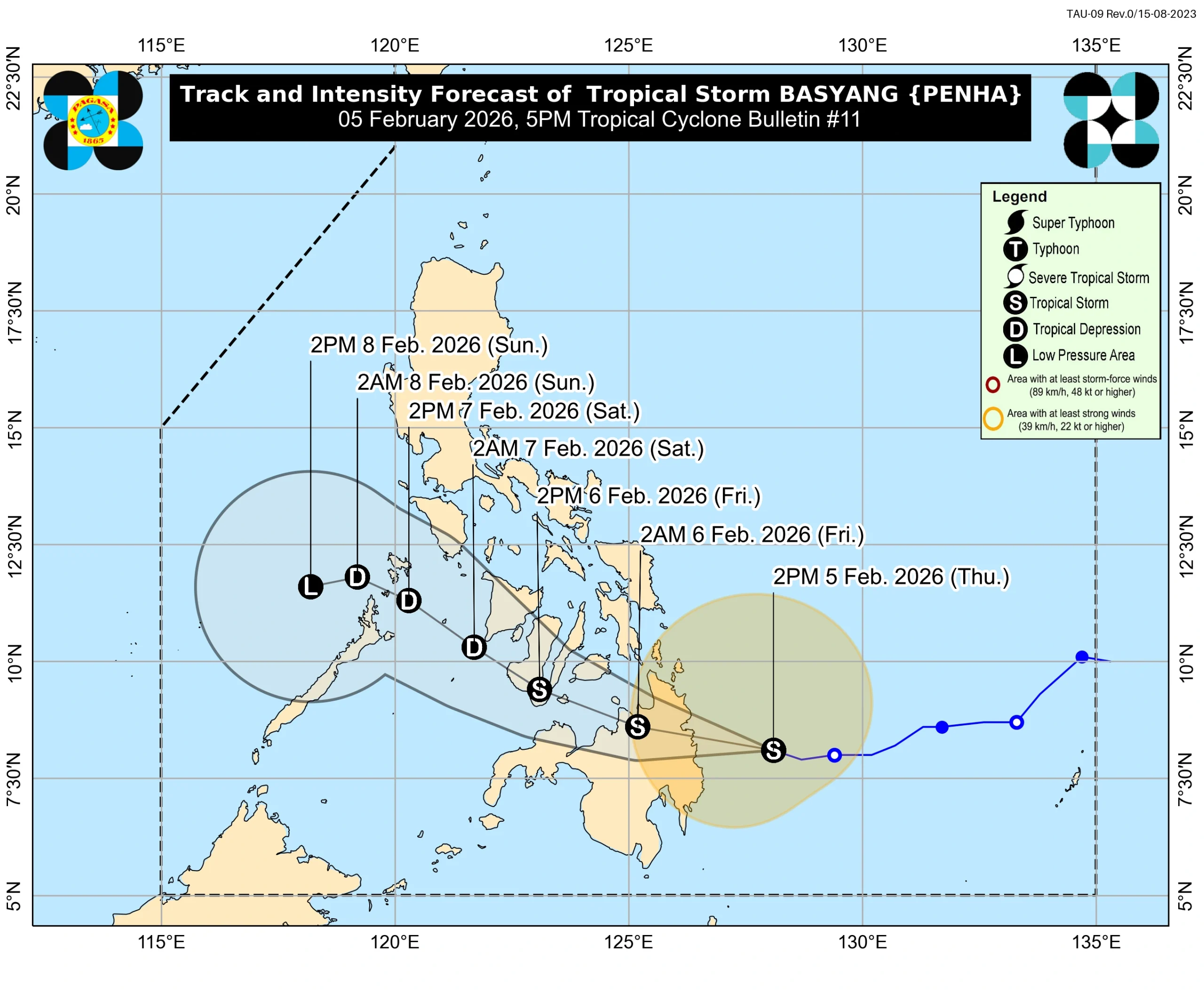
Tropical Storm Penha, known locally as Basyang, is forecast to make multiple landfalls across the southern and central Philippines, beginning with Surigao del Sur late February 5 or early February 6, 2026. The system is forecast to cross Mindanao and may pass close to or make landfall over Siquijor and southern Negros Oriental before moving toward Palawan.
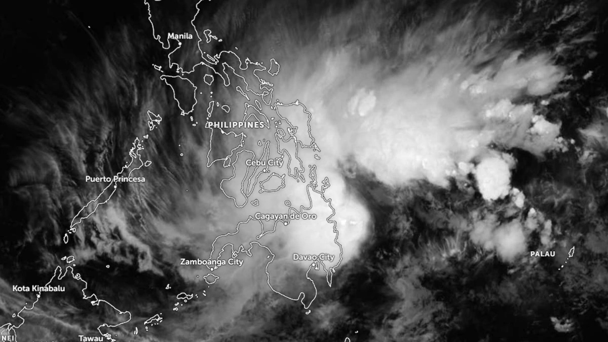
Satellite image of Tropical Storm Penha (Basayang) at 11:20 UTC on February 5, 2026. Credit: JMA/Himawari-9, Zoom Earth, The Watchers
Tropical Storm Penha (Basyang) is slowly intensifying as it moves towards eastern Mindanao on February 5, with intense rainfall, strong winds, and hazardous marine conditions forecast to affect large portions of Mindanao and the Visayas over the next several days, according to the Philippine Atmospheric, Geophysical and Astronomical Services Administration.
At 16:00 LT (08:00 UTC), the center of Penha was located about 150 km (93 miles) east of Hinatuan, Surigao del Sur. The system had maximum sustained winds of 75 km/h (45 mph) near the center, gusts of up to 90 km/h (55 mph), and a minimum central pressure of 998 hPa. It was moving west-northwestward at 25 km/h (16 mph) and had slightly intensified while approaching land.
Penha will make its initial landfall over Surigao del Sur late on February 5 or early on February 6, before crossing Mindanao and emerging over the Bohol Sea later on February 6.
The cyclone may pass close to or make another landfall over Siquijor and southern Negros Oriental by the afternoon or evening of February 6, then traverse the Sulu Sea and the northern portion of Palawan between February 7 and February 8.
Rainfall associated with Penha is expected to be the primary hazard, with rainfall totals exceeding 200 mm (8 inches) through February 6 over Surigao del Sur, Agusan del Norte, Agusan del Sur, Misamis Oriental, and Camiguin, where widespread severe flooding and landslides are considered likely.
Rainfall of 100–200 mm (4–8 inches) is forecast across large parts of the Visayas and Mindanao, including Southern Leyte, Cebu, Bohol, the Negros Island Region, Siquijor, Dinagat Islands, Bukidnon, Lanao del Norte, Davao de Oro, and Davao Oriental. Flooding is likely in low-lying and river-adjacent areas, with higher rainfall amounts possible over mountainous terrain.
Additional rainfall of 50–100 mm (2–4 inches) is forecast for other areas of the Visayas and Mindanao, where localized flooding is possible, particularly in urbanized and low-lying locations. PAGASA noted that antecedent rainfall could further increase runoff and flood potential in susceptible basins.
Tropical Cyclone Wind Signal No. 2 is in effect over parts of Negros Oriental, Negros Occidental, Cebu, Bohol, and Siquijor, as well as portions of northeastern and northern Mindanao, due to the risk of strong winds reaching 62–88 km/h (39–55 mph).
Tropical Cyclone Wind Signal No. 1 covers a broader area across MIMAROPA, the Visayas, and Mindanao, where winds of 39–61 km/h (24–38 mph) are forecast and may cause minimal to minor impacts, particularly in exposed coastal and upland areas.
Marine conditions are forecast to deteriorate significantly as the cyclone nears land. A Gale Warning remains in effect over the eastern and central seaboards of the Visayas and the northern and eastern seaboards of Mindanao.
Very rough seas of up to 5.5 m (18 feet) are expected along the Surigao del Sur seaboard, with waves reaching 5 m (16 feet) along the coasts of Surigao del Norte, Siargao, Bucas Grande Islands, and the Dinagat Islands. Sea travel is considered dangerous for all types of vessels in these waters, with mariners advised to remain in port or seek shelter until conditions improve.
Penha may intensify slightly prior to landfall, then weaken as it interacts with land, likely remaining a tropical storm through February 6. Further weakening into a tropical depression is forecast by February 7, with the system expected to degenerate into a low-pressure area by February 8.
References:
1 Tropical Cyclone Bulletin No. 11: Tropical Storm Basyang (PENHA) – PAGASA – February 5, 2026
2 Weather Advisory No. 26: Heavy rainfall outlook due to Tropical Cyclone Basyang – PAGASA – February 5, 2026

I am an Assistant Editor and Severe Weather & Science Journalist at The Watchers, specializing in real-time severe weather coverage, geophysical event reporting, and research-driven scientific analysis. You can reach me at rishav(at)watchers(.)news.
Commenting rules and guidelines
We value the thoughts and opinions of our readers and welcome healthy discussions on our website. In order to maintain a respectful and positive community, we ask that all commenters follow these rules.