
Wind chills to −57°C (−70°F) as Extreme Cold and Blizzard Warnings continue across Alaska
Extreme Cold Warnings and Blizzard Warnings remain in effect across northern and western Alaska on February 11, 2026, with the National Weather Service forecasting wind chills as low as −57°C (−70°F) along the Arctic Coast and Brooks Range and wind gusts up to 105 km/h (65 mph) on St. Lawrence Island. Air temperatures near −46°C (−50°F) combined with increasing winds are expected to intensify frostbite risk across the North Slope, while snowfall of 7–15 cm (3–6 inches) and visibility reductions to 400 m (0.25 miles) or less are forecast in parts of western Alaska through early February 12.
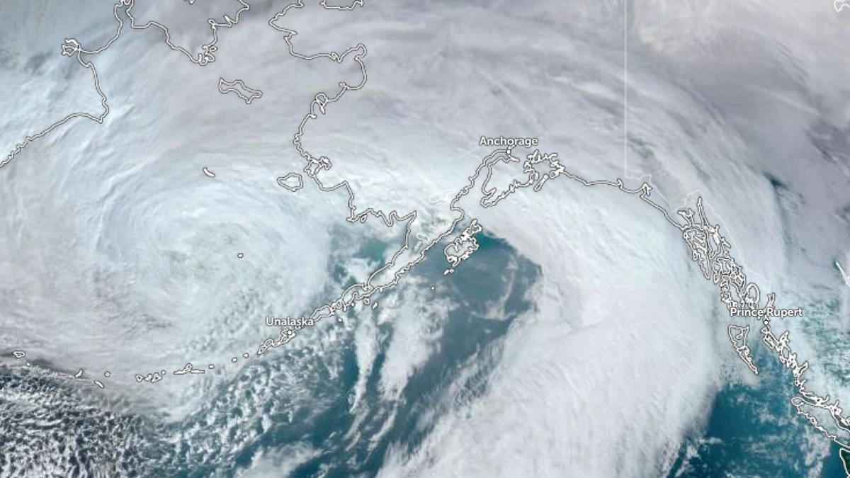
Satellite image of Alaska at 2300 UTC on February 10, 2026. Credit: NOAA/GOES-18, Zoom Earth, The Watchers
Extreme Cold Warnings remain in effect across the Arctic Coast, Arctic Plains, and the Brooks Range of northern Alaska, according to advisories issued by the National Weather Service (NWS) Fairbanks office. The warnings cover locations including Utqiagvik, Prudhoe Bay, Deadhorse, Point Hope, Anaktuvuk Pass, and sections of the Dalton Highway.
Wind chills are forecast to reach as low as −57°C (−70°F), with ambient air temperatures near −46°C (−50°F). NWS Fairbanks states that exposed skin may develop frostbite in as little as five minutes under such extremely cold conditions. Increasing winds Tuesday into Wednesday are expected to intensify the wind chill threat before temperatures slowly moderate.
A separate Extreme Cold Warning remains in effect for Arctic Village until 06:00 AKST on February 11, where wind chills as low as −57°C (−70°F) are also forecast.
Blizzard Warnings are active across western Alaska, including the Kuskokwim Delta Coast and Nunivak Island, where winds are forecast to gust up to 65 km/h (40 mph) with additional snowfall up to 2.5 cm (1 inch) through 03:00 AKST on February 11. Whiteout conditions are possible, and travel may be very difficult and potentially life-threatening in exposed areas.
Across Eastern Norton Sound, the Yukon Delta Coast, the Lower Yukon River, and St. Lawrence Island, Blizzard Warnings remain in effect into early February 12. Snow accumulations of 7–15 cm (3–6 inches) are forecast for portions of Norton Sound and the Yukon Delta Coast, with wind gusts up to 90 km/h (55 mph) in some areas and up to 105 km/h (65 mph) on St. Lawrence Island. Visibility may be reduced to 400 m (0.25 miles) or less during periods of blowing and falling snow.
A Blizzard Warning has also been issued for the Western Arctic Coast from 03:00 AKST on February 11 through 21:00 AKST on February 12, where gusts up to 80 km/h (50 mph) and snowfall up to 5 cm (2 inches) are forecast. Blowing snow is expected to significantly reduce visibility once snowfall develops.
Steady snow continues across much of Southcentral Alaska as a vigorous upper-level shortwave lifted northward across the Kenai Peninsula and Cook Inlet. Anchorage recorded 7.9 cm (3.1 inches) of snowfall by 16:37 AKST on February 10 with light snow ongoing during the afternoon. Visibility remained below 1.6 km (1 mile) at times across the Western Kenai Peninsula, including Kenai Airport.
Snowfall is forecast to intensify again during the evening hours, with an additional 3–10 cm (1–4 inches) across Anchorage and surrounding areas. Localized higher totals remain possible depending on band placement. Winter Weather Advisories remain in effect for the Susitna Valley, the Western Kenai Peninsula, Turnagain Pass, and the northern Copper River Basin, including Paxson and Thompson Pass.
Snow is forecast to transition to a more showery regime on February 11 as colder air advects inland from the southwest. Snowband placement remains uncertain due to the potential development and track of a secondary low-pressure system.
A track up Cook Inlet would favor additional accumulation for Anchorage and the Western Kenai Peninsula, while a more easterly track would shift heavier totals toward Turnagain Pass, Moose Pass, Portage, and Whittier.
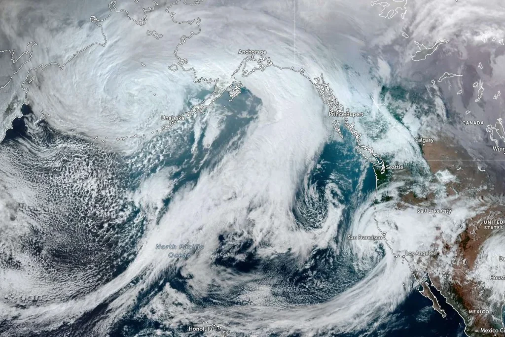
Across Southwest Alaska, a large Bering Sea low continued to move slowly northwest of the Pribilof Islands on February 10. Blizzard conditions persisted along the Kuskokwim Delta Coast, including the Bethel area, as strong winds combined with falling and blowing snow. The Winter Weather Advisory for the Pribilof Islands remained in effect through the evening.
Temperatures behind the associated frontal boundary are forecast to rise to between −2 and 0°C (28 to 32°F), remaining near or below the freezing point across most of the region.
Snow showers are expected to persist through February 11, with gusty winds maintaining localized areas of blowing snow. Coastal impacts are forecast to remain limited due to extensive sea ice and shorefast ice coverage.
Conditions are forecast to quiet down across Southcentral Alaska on February 12–13 as the next Gulf low tracks into the eastern Gulf and Southeast Alaska. Tightening pressure gradients between the Gulf system and inland high pressure are expected to produce gusty gap winds through favored passes.
A new low-pressure system is forecast to enter the eastern Bering Sea before moving inland across Southwest Alaska and the Alaska Peninsula between February 14–17. Moderate to heavy snowfall is forecast for much of Southwest Alaska, while rainfall is expected across portions of the Alaska Peninsula. The surface low is forecast to consolidate in the northern Gulf by February 15, increasing snowfall potential across inland Southcentral Alaska.
References:
1 Blizzard Warning – NWS – February 10, 2026
2 Extreme Cold Warning – NWS – February 10, 2026
3 Area Forecast Discussion – NWS – February 10, 2026

I am an Assistant Editor and Severe Weather & Science Journalist at The Watchers, specializing in real-time severe weather coverage, geophysical event reporting, and research-driven scientific analysis. You can reach me at rishav(at)watchers(.)news.
Commenting rules and guidelines
We value the thoughts and opinions of our readers and welcome healthy discussions on our website. In order to maintain a respectful and positive community, we ask that all commenters follow these rules.