
Cross-country storm to bring heavy rain to the South and snow to the West and Great Lakes
An atmospheric river affecting California on February 11, 2026, is forecast to evolve into a cross-country storm moving across the southern U.S. through February 13–14, 2026. Widespread rainfall totals of 25 to 75 mm (1–3 inches), with locally higher amounts, are possible across Texas to Georgia. Heavy snow is ongoing in the Sierra Nevada, with additional accumulations expected in the Wasatch and central Rockies.
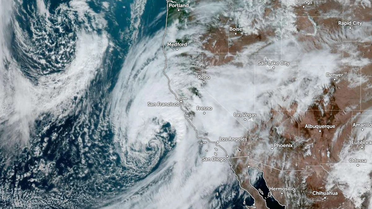
Satellite image of atmospheric river over southern California at 20:00 UTC on February 10, 2026. Credit: NOAA/GOES-19, Zoom Earth, The Watchers
An atmospheric river that made landfall in California during the early hours of February 11 is forecast to bring severe weather across much of the United States through February 14.
Moderate rain is already affecting coastal California and the Central Valley, while heavy snow is falling in the Sierra Nevada.
Precipitation will intensify as the system shifts into the central Great Basin and central Rockies. Lower elevations are already seeing light rain, while heavy mountain snow is expected in the Wasatch Range and central Rockies through February 12.
A secondary surge of upper-level energy is forecast to bring additional precipitation to the southern Plains from late February 12 into February 13, supporting the development and strengthening of a surface low and southerly flow from the Gulf of Mexico. This will increase moisture transport into Texas, Louisiana, Mississippi, Alabama, and Georgia.
Rainfall totals of 25–75 mm (1–3 inches) are forecast across portions of the southern Plains and Lower Mississippi Valley from February 12 into February 14. Localized totals of 75–125 mm (3–5 inches) are possible where frontal convergence and training thunderstorms align. Urban and poor-drainage flooding may occur in areas receiving higher-end totals.
The rainfall event is occurring within a broader anomalously warm air mass across much of the central and southern United States.
Temperatures are running 8–11°C (15–20°F) above mid-February averages across portions of the central Plains, Middle Mississippi Valley, and southern tier. Forecast highs through February 13 are expected to reach 15–21°C (60–70°F) across the southern Plains and Southeast, supporting elevated atmospheric moisture content and rainfall efficiency.
Farther north, colder air wrapping around the system is producing lake-enhanced snow downwind of Lakes Erie and Ontario on February 11. Upslope snow is also affecting parts of the central Appalachians and interior New England. Some areas may receive moderate to locally heavy additional accumulations before activity diminishes.
The Northeast and Great Lakes will trend colder following frontal passage, with daytime highs generally in the −7 to 4°C (20s–30s°F) range by February 12–13. In contrast, much of the Intermountain West will remain above average ahead of the trough, with highs in the 4–15°C (40s–50s°F) range before cooling behind the system.
The evolving pattern represents a transition from a West-focused precipitation regime toward a more consolidated southern-tier storm track. The extent of heavier rainfall across the Gulf Coast and Southeast will depend on the timing and track of the developing surface low and the placement of the frontal boundary through February 14.

I am an Assistant Editor and Severe Weather & Science Journalist at The Watchers, specializing in real-time severe weather coverage, geophysical event reporting, and research-driven scientific analysis. You can reach me at rishav(at)watchers(.)news.
Commenting rules and guidelines
We value the thoughts and opinions of our readers and welcome healthy discussions on our website. In order to maintain a respectful and positive community, we ask that all commenters follow these rules.