
Tropical Storm Melissa may reach major hurricane strength as it tracks near Hispaniola and Jamaica
Tropical Storm Melissa could strengthen into a major hurricane over the weekend as it moves slowly through the central Caribbean on Wednesday, October 22, 2025. The system is forecast to bring heavy rainfall and flooding across parts of Hispaniola and Jamaica through the remainder of the week.
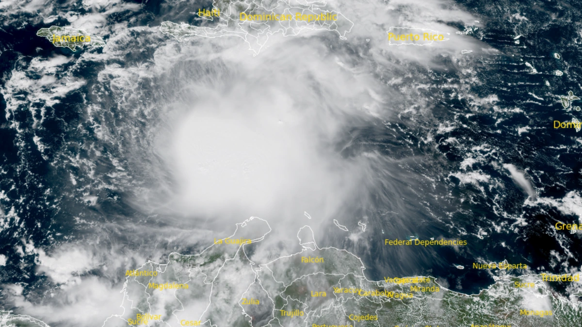
Satellite image of Tropical Storm Melissa at 16:40 UTC on October 22, 2025. Credit: NOAA/GOES-19, RAMMB/CIRA, The Watchers
Tropical Storm Melissa continues to move very slowly west-northwestward in the central Caribbean, producing heavy rainfall and localized flooding over parts of Hispaniola and Jamaica.
At 11:00 EDT (15:00 UTC) on October 22, the storm’s center was located about 485 km (300 miles) south-southwest of Port-au-Prince, Haiti, and 525 km (325 miles) southeast of Kingston, Jamaica.
Maximum sustained winds (averaged over 1-minute) reached 85 km/h (50 mph), with higher gusts. The minimum central pressure was estimated at 1 000 hPa. Melissa is moving west-northwest at about 4 km/h (2 mph).
Some gradual strengthening is anticipated during the next few days, and the system could become a hurricane by Friday, October 24. The forecast indicates Melissa could continue to strengthen and become a major hurricane by the weekend.
A Hurricane Watch remains in effect for the southwestern peninsula of Haiti, from the Dominican Republic border to Port-au-Prince, while a Tropical Storm Watch is in effect for Jamaica.
According to the National Hurricane Center (NHC), Melissa remains a disorganized tropical system under persistent west-northwesterly wind shear of 37–46 km/h (23–29 mph), which prevents the low- and mid-level circulation centers from aligning.
Although convection continues to burst with very cold cloud tops down to –95 °C (–139 °F), the storm’s structure remains tilted and asymmetric. A recent radar pass indicated that most tropical-storm-force winds are located east of the center.
The cyclone is forecast to move very slowly to the northwest as it drifts toward a weakness created by an upper-level trough over the Bahamas
The GFS and DeepMind ensemble guidance show a northeastward motion toward Hispaniola, while the ECMWF and its ensemble mean suggest a slower north-northwest track, keeping the system misaligned.
The official NHC forecast lies slightly east of the ECMWF mean, favoring a gradual northwest drift followed by a westward turn later this week.

Vertical wind shear is expected to persist through the next 48 hours, limiting short-term organization. After that period, the shear should begin to decrease, allowing Melissa to become more vertically coherent.
Most model guidance indicates significant or even rapid intensification between days three and five. The NHC forecast shows Melissa reaching major hurricane strength by day five, though both track and intensity forecasts remain highly uncertain.
Melissa is forecast to produce 127–254 mm (5–10 inches) of rain over southern Haiti, the southern Dominican Republic, and eastern Jamaica through Saturday, with locally higher amounts possible.
Northern Hispaniola, Puerto Rico, and western Jamaica are expected to receive 51–102 mm (2–4 inches). Additional heavy rainfall is possible beyond Saturday, October 25; however, uncertainty in the storm’s track and forward speed reduces confidence in exact totals. Significant flash flooding and landslides are possible, especially in mountainous terrain.
Swells generated by Melissa are expected to spread to Hispaniola, Jamaica, and eastern Cuba during the next couple of days, producing hazardous surf and rip current conditions. Residents in affected areas should consult products from their local weather offices for details.
References:
1 Tropical Storm Melissa Advisory Number 5 – NHC – October 22, 2025
2 Tropical Storm Melissa Discussion Number 5 – NHC – October 22, 2025

I am an Assistant Editor and Severe Weather & Science Journalist at The Watchers, specializing in real-time severe weather coverage, geophysical event reporting, and research-driven scientific analysis. You can reach me at rishav(at)watchers(.)news.
Commenting rules and guidelines
We value the thoughts and opinions of our readers and welcome healthy discussions on our website. In order to maintain a respectful and positive community, we ask that all commenters follow these rules.