
Tropical Storm Ivo triggers severe floods in Nayarit and Veracruz, Mexico
Tropical Storm Ivo brought heavy rainfall and severe flooding to parts of western and southern Mexico on August 7, 2025, causing widespread damage in Nayarit and Veracruz and injuring two people in Durango.
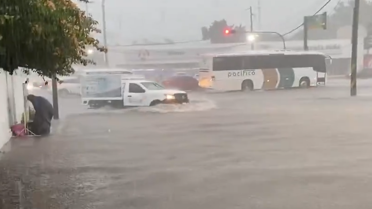
Flooding in Avenida Xalisco, Tepic, Nayarit, Mexico on August 7, 2025. Credit: WeatherMonitors
Tropical Storm Ivo brought heavy rains and severe flooding across western and southern Mexico on August 7. The floods caused widespread damage in multiple states, with Nayarit and Veracruz the worst affected.
Rainfall rates of up to 100 mm (3.94 inches) per hour were recorded in parts of Tepic, capital of Nayarit, between 15:30 and 16:20 LT on August 7. Around 43 mm (1.69 inches) was recorded in Los Sauces, east of Tepic, during this period, while 40 mm (1.57 inches) was recorded in downtown Tepic and 28 mm (1.10 inches) near Universidad Autónoma de Nayarit (UAD).
Residential areas including Ciudad del Valle, Gobernadores, Oriental, Comerciantes, Hermosa Provincia, Morelos, Caja de Agua, Jacarandas, and Villas de Cantera reported water entering homes. In Jacarandas and Villas de Cantera, an overflowing canal worsened flooding impacts.
This afternoon: Heavy floods in Avenida Xalisco, Tepic, Nayarit, Mexico. August 07, 2025. pic.twitter.com/F4aYiOWyHz
— Weather Monitor (@WeatherMonitors) August 8, 2025
In Milpillas, Pueblo Nuevo municipality, Durango, heavy rain caused a tree to collapse, injuring two people — a 33-year-old woman and a 9-year-old girl. Both were hospitalized in Durango City and remain in stable condition.
In Mazatlán, strong currents swept away two children after heavy rainfall. Fortunately, both children were successfully rescued and were safe.
“¡mira, mira, la niña!agarrénla!” Así fue el momento donde dos menores son arrastradas por la fuerte corriente tras las intensas lluvias registradas #Mazatlán. Por fortuna pudieron ser salvadas. pic.twitter.com/okXqL6qpXB
— Luis Alberto Díaz y Los Noticieristas (@noticieristas) August 8, 2025
In southern Veracruz, Tropical Wave No. 20 combined with moisture from Ivo to cause the Coatzacoalcos River to overflow, inundating multiple rural communities. These include Lázaro Cárdenas, El Halcón, Paso de los Indios, San Lorenzo Tenochtitlán, Morelos, Peña Blanca, Xochitepec, Ixtepec, Camelias, and Villalta.
A sinkhole opened on the Copal bridge, which connected these communities, isolating them and hampering rescue operations.
#BREAKING#UPDATE
— GlobalFeedX (@GlobalFeedX) August 7, 2025
FLASH FLOODING HITS MEXICO!
Severe flooding devastates El Juile, Veracruz, leaving trail of destruction! #Mexico #Floods #BreakingNews #Weather #NEWS #TrumpTariffs #America #NYC #incendie #فويس #WilliamEst #AHOF #ENHYPEN #ALERT #US #timelesz_episode1 pic.twitter.com/CbjmMUhIUF
Severe flooding in Tepic, Nayarit in Mexico yesterday… pic.twitter.com/POizYbdxHg
— Volcaholic (@volcaholic1) August 8, 2025
According to the advisory issued by the National Hurricane Center at 02:00 MST (09:00 UTC) on August 8, Ivo was located approximately 290 km (180 miles) south-southeast of the southern tip of Baja California. Maximum sustained winds reached 95 km/h (59 mph). Estimated minimum central was 1 001 hPa as the storm moved west-north-west at 34 km/h (21 mph).

While Ivo is not forecast to make landfall, moving just past the coast of Mexico, it could strengthen into a hurricane on August 8, before weakening during the weekend.
Swells generated by Ivo will continue to affect the southwestern coast of Mexico during the next day or so, and are forecast to reach the southern portion of the Baja California peninsula later on August 8. These swells are likely to cause life-threatening surf and rip current conditions.

I am an Assistant Editor and Severe Weather & Science Journalist at The Watchers, specializing in real-time severe weather coverage, geophysical event reporting, and research-driven scientific analysis. You can reach me at rishav(at)watchers(.)news.
Commenting rules and guidelines
We value the thoughts and opinions of our readers and welcome healthy discussions on our website. In order to maintain a respectful and positive community, we ask that all commenters follow these rules.