
North Dakota and Minnesota brace for severe thunderstorms as dynamic system moves east
Severe thunderstorms threaten North Dakota, eastern Montana, and northwest Minnesota on August 8, 2025, with damaging winds, large hail, and possible tornadoes, while extreme heat affects over 40 million people across the central U.S. The National Weather Service forecasts continued storm risks into August 9, alongside flash flooding concerns in Iowa, southern Wisconsin, and northern Illinois.
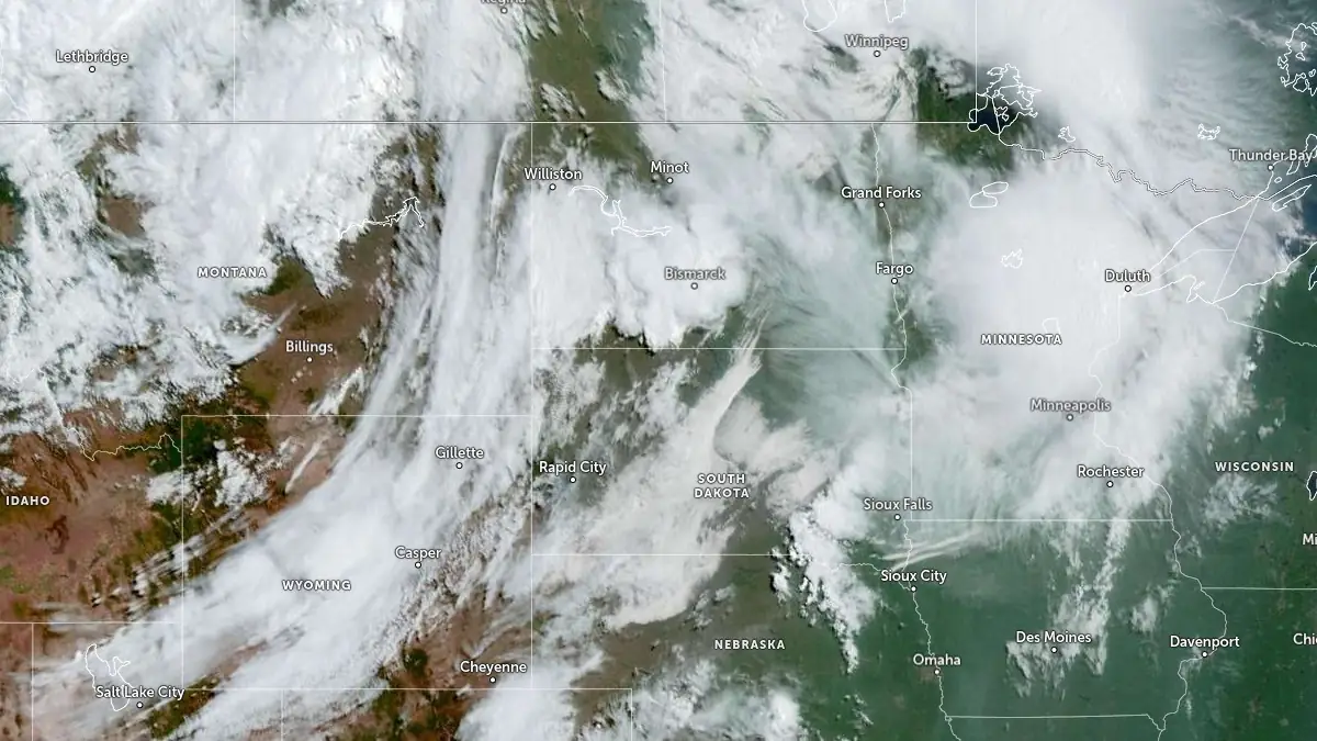
Satellite image acquired at 14:50 UTC on August 8, 2025. Credit: NOAA/GOES-East, Zoom Earth, The Watchers
The National Weather Service’s Storm Prediction Center (SPC) issued an Enhanced Risk Outlook (Level 3/5) at 12:25 local time (LT) on August 8, for North Dakota, eastern Montana, and northwest Minnesota.
Severe thunderstorms are expected to produce damaging winds up to 129–145 km/h (80–90 mph), hail up to 5 cm (2 inches), and a few tornadoes.
The storms, driven by a potent upper-level shortwave and a strong surface low, will start in North Dakota around 08:00 LT and spread to eastern Minnesota by evening.
Approximately 5.5 million people are at risk, including residents of major cities like Minneapolis, St. Paul, Duluth, Sioux Falls, and Fargo. The SPC notes that storms may form into a Mesoscale Convective System (MCS), increasing the threat of widespread damaging winds.
The previous night’s storms on August 7 brought wind gusts exceeding 97 km/h (60 mph) across eastern Montana and North Dakota.
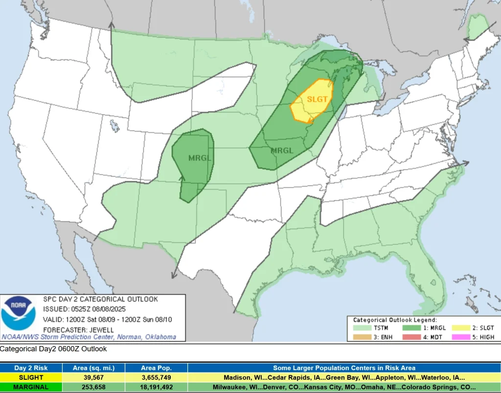
On August 9, 2025, the SPC’s Day 2 Convective Outlook (SPC AC 080525) forecasts a Slight Risk (Level 2/5) of severe thunderstorms from northeast Iowa to southern Wisconsin.
A moist and unstable air mass with dewpoints of 16–21°C (60–70°F) will fuel storms, producing damaging winds, large hail, and a low risk of tornadoes. The forecast is complicated by potential storms around 12:00 LT that could destabilize the air mass prematurely.
A separate Slight Risk is noted for the central High Plains, including southeast Colorado to the Front Range, on August 9. East-southeast surface winds and dewpoints of 10–15°C (50°–60F) will create strong instability, supporting isolated cells capable of large hail and brief tornadoes. Capping and uncertain storm coverage currently limit higher severe probabilities in this region.
Excessive rainfall poses a flash flooding risk across eastern Montana and North Dakota on August 8, with 50–100 mm (2–4 inches) rainfall totals possible due to high moisture and instability.
The Weather Prediction Center (WPC) indicates this risk will shift to Iowa, southern Wisconsin, and northern Illinois from August 9 to 10. Fast-moving storms may reduce widespread flooding, but isolated risks remain due to strong moisture transport.
Over 40 million people across Minnesota, Iowa, Nebraska, Missouri, Kansas, Oklahoma, Texas, and other states are under heat advisories on August 8. Heat indices of 38–43°C (100–110°F) are expected due to high temperatures and humidity, with minimal overnight relief as lows remain in the 24–27°C (75–80°F) range. The heat wave is expected to persist through August 10 in the Midwest and Great Lakes.
In the Desert Southwest, including Arizona and eastern California, temperatures of 43–46°C (110–115°F) are forecast to drop by 3–6°C (5–10°F) from August 9 to 10.
Severe weather could damage property, such as roofs, siding, and trees, and vehicles, with hail posing risks to people and animals outdoors. Residents are advised to monitor updates and prepare for potential warnings.

I’m a science journalist and researcher at The Watchers, contributing to the Epicenter edition, where I cover peer-reviewed scientific research and emerging discoveries across Earth and space sciences. With a background in astronomy and a passion for environmental science, I’ve worked in shark and coral conservation in Fiji, conducting reef and shark-behavior research, contributing to mangrove restoration, and earning PADI Open Water and Coral Reef Certifications. I bring a blend of scientific rigor and storytelling to illuminate the discoveries shaping our planet and beyond.
Commenting rules and guidelines
We value the thoughts and opinions of our readers and welcome healthy discussions on our website. In order to maintain a respectful and positive community, we ask that all commenters follow these rules.