
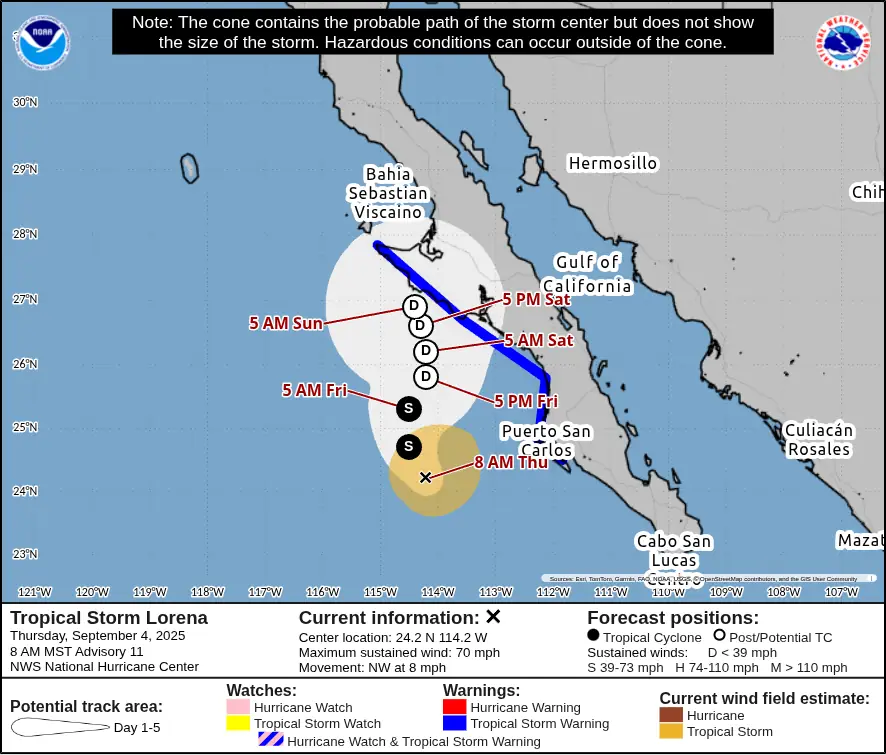
Lorena weakens to tropical storm but continues to pose flooding risk in Baja California Sur and U.S. Southwest
Hurricane Lorena weakened into a tropical storm on September 4, 2025, after bringing heavy rains and flooding to Los Cabos, Mexico. The storm, though no longer expected to make landfall, is still going to bring life-threatening flood conditions to Baja California Sur, Sonora, and parts of the southwestern United States.
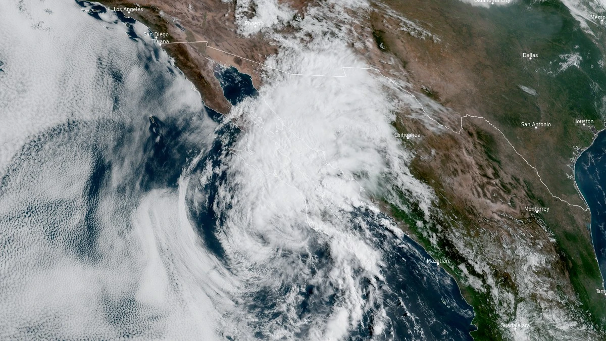
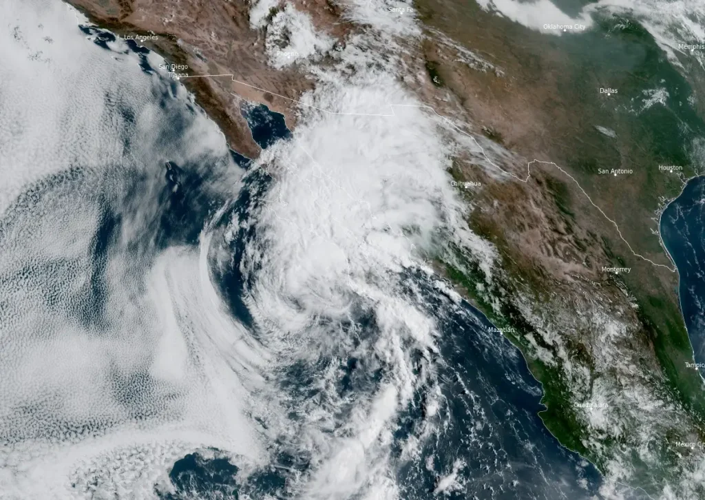
Satellite image of Tropical Storm Lorena at 16:10 UTC on September 4, 2025. Credit: NOAA/GOES-West, RAMMB/CIRA, The Watchers
- Heavy rainfall from Lorena will continue to affect Baja California Sur and Sonora through Friday, September 5, bringing an increased risk of life-threatening flash floods and mudslides across northwestern Mexico.
- Moisture associated with Lorena will extend into the southwestern United States, with Arizona and New Mexico expected to receive heavy rainfall through Saturday, September 6. This will bring the potential for isolated to scattered flash flooding, particularly in Arizona.
- The center of Lorena is forecast to move parallel to, but remain offshore of, the southwestern coast of the Baja California Peninsula through tonight before approaching the west-central coast on Friday as it weakens. Tropical storm conditions, mainly in gusts, are likely along parts of Baja California Sur today through Friday, where a Tropical Storm Warning is in effect.
- Dangerous surf and rip currents will continue to impact the southern and western coasts of Baja California Sur over the next couple of days.
Hurricane Lorena weakened to a tropical storm early on September 4, 2025, while moving west-southwest of Cabo San Lázaro, Mexico.
Heavy rainfall from the system affected parts of Baja California Sur, particularly Los Cabos, where flooding disrupted hospitals and prompted the deployment of the Mexican National Guard to clear debris and restore access to streets.
While the cyclone is expected to continue weakening and degenerate into a remnant low within 36 hours, it will still deliver life-threatening rainfall and flash flooding across Baja California Sur, Sonora, and into the U.S. Southwest.
At 15:00 UTC (08:00 MST) on September 4, the center of Tropical Storm Lorena was located about 205 km (125 miles) west-southwest of Cabo San Lázaro, Mexico. Lorena is moving northwest at 13 km/h (8 mph).
Maximum sustained winds have decreased to 110 km/h (70 mph), with higher gusts, and the estimated minimum central pressure is 991 hPa. Tropical-storm-force winds extend outward up to 110 km (70 miles) from the center.
Lorena has crossed below the 26°C (79°F) isotherm and is being impacted by around 37 km/h (23 mph) of southwesterly wind shear.
Microwave imagery shows the low-level center displaced from deep convection, with thunderstorm activity sheared northeastward. The National Hurricane Center (NHC) lowered the initial intensity to 110 km/h (70 mph), confirming Lorena’s downgrade to tropical storm status.
Lorena is forecast to move slowly northwestward September 4, before turning north and northeast later in the night into September 5.
The 15:00 UTC from the NHC represents a large change from the previous forecast, and now keeps the center of Lorena offshore.
According to NHC forecasters Hagen and Brown, the GFS model and all of NHC’s consensus guidance, including the HCCA, Google DeepMind, and TCVE, have come onboard to the solution that the ECMWF, UKMET, and CMC models have been advertising for the past couple of days, which shows Lorena slowing down and dissipating offshore, to the west of Baja California.
The only models that still bring Lorena’s center into the Baja California peninsula are the HAFS models and the HMON, as a weak low, below tropical storm strength.
As Lorena’s convection gets stripped off toward the northeast, its path will soon be governed by the low-level steering currents, which should keep Lorena moving slowly offshore as it weakens.
The risk of life-threatening flash flooding persists in Baja California Sur and southwestern Sonora, with bands of heavy rainfall expected to affect these regions through Friday, September 5.
Baja California Sur, southeastern Baja, and southwestern Sonora can expect 100–200 mm (4–8 inches) of additional rainfall, with maximum storm total amounts of 380 mm (15 inches), through September 5. This will bring the risk of life-threatening flash floods and mudslides, especially in areas of higher terrain.
Rainfall totals of 50–100 mm (2–4 inches), with isolated maximums up to 150 mm (6 inches), are expected in Sonora and northern Sinaloa, potentially leading to isolated to scattered instances of flash flooding.
Across the southwestern United States, 25–75 mm (1–3 inches) of rainfall, with isolated totals up to 125 mm (5 inches), are expected in parts of Arizona and New Mexico through Saturday, September 6, bringing the potential for isolated to scattered flash flooding.
The government of Mexico discontinued the Tropical Storm Watch for the east coast of the Baja California Peninsula from Santa Rosalia to Bahia de los Angeles and the Tropical Storm Warning along the west coast south of Puerto Cortes.
As of 15:00 UTC (08:00 MST), a Tropical Storm Warning remains in effect for the west coast of Baja California Sur from Puerto Cortes to Punta Eugenia, where tropical storm conditions are expected.
Other areas of the Baja California Peninsula and northwestern Mexico should continue to monitor the progress of Lorena.
Swells will continue to impact the southern and western coasts of Baja California Sur through September 5, producing life-threatening surf and rip currents.

I am an Assistant Editor and Severe Weather & Science Journalist at The Watchers, specializing in real-time severe weather coverage, geophysical event reporting, and research-driven scientific analysis. You can reach me at rishav(at)watchers(.)news.
Commenting rules and guidelines
We value the thoughts and opinions of our readers and welcome healthy discussions on our website. In order to maintain a respectful and positive community, we ask that all commenters follow these rules.