
Unseasonal heavy rain and strong cold front hit Western Australia, leaving 40 000 properties without power
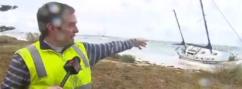
Image credit: 7News Perth
Unseasonal rain, in parts record-breaking, and a strong cold front hit Western Australia on June 4 and 5, 2018, leaving more than 40 000 properties without power. On average, this region sees fronts like this about five times per year.
Damaging wind gusts up to 109 km/h (68 mph) and heavy rain left more than 40 000 properties without power in southern Western Australia today. The state's utility said restoring power from Kalbarri to Albany may be slow as bad weather hampers repair works.
"We expect to restore power to Albany town center Tuesday evening, and our crews will continue to work throughout the night to inspect and restore power to the greater Albany area. Additional crews will be back at first light on Wednesday morning, and, weather permitting, we’ll be able to use helicopter patrols," a Western Power spokesperson said.
According to Australia Bureau of Meteorology (BOM) spokesperson, Neil Bennet, the conditions were expected to ease over Perth late Tuesday afternoon.
"Rains arrived early this year after several seasons of winter starting and finishing late in Western Australia's south," Bennet said.
WINTER BLAST
A big storm has been battering WA with record-breaking levels of rain falling in our north-west. pic.twitter.com/uMBKOIoZTu— 7 News Perth (@7NewsPerth) June 5, 2018
Strong & squally winds over the Perth Metro area with showers streaming through. The front has moved through the SW Capes with conditions expected to ease during the afternoon. Severe Weather Warning for Damaging Winds & Abnormally High Tides continues https://t.co/NikaX4QRKr pic.twitter.com/ECyQYvUs1r
— Bureau of Meteorology, Western Australia (@BOM_WA) June 5, 2018
@weather_wa @BOM_WA @BunburyWeather @TheWAWG Bit wet on Busso pic.twitter.com/G8rQgrzAB1
— Barbara Hossen (Barb) (@BarbHossen) June 5, 2018
Keep us going strong – subscribe today and get your ad-free account
Producing content you read on this website takes a lot of time, effort, and hard work. If you value what we do here, please consider subscribing today.
Satellite loop shows the front crossing the west coast. Lots of showery cloud packed in behind the front. The showers are shown as the "speckled" cloud to the SW of #WA. #Perthstorm #perthweather. https://t.co/ZUXJ65mYRB pic.twitter.com/O2EUTydb6G
— Bureau of Meteorology, Western Australia (@BOM_WA) June 5, 2018
24 hour rainfall totals to 9am this morning.https://t.co/9xe7Hd7Oxn pic.twitter.com/WYU9I50plK
— Bureau of Meteorology, Western Australia (@BOM_WA) June 5, 2018
Farmers have benefited from record rains pelting Gascoyne, with Denham recording 98 mm (3.8 inches) of rain in the 24 hours to 09:00 local time June 5, Perth Now reports. This broke its previous monthly record set in June 1965.
Officials urged people to avoid coastal waters as high tides and rough seas could erode beaches, with swells from 3 to 5 m (10 – 16 feet) expected.
"As we head into Wednesday the heavier rain will extend further inland through the Pilbara, and we'll see some follow up showers for parts of the southwest," BOM's senior meteorologist, Adam Morgan, said.
Rain is likely to continue over Perth until the weekend, with a chance of thunderstorms from late Tuesday to Thursday, June 7.
I'm a dedicated researcher, journalist, and editor at The Watchers. With over 20 years of experience in the media industry, I specialize in hard science news, focusing on extreme weather, seismic and volcanic activity, space weather, and astronomy, including near-Earth objects and planetary defense strategies. You can reach me at teo /at/ watchers.news.
Commenting rules and guidelines
We value the thoughts and opinions of our readers and welcome healthy discussions on our website. In order to maintain a respectful and positive community, we ask that all commenters follow these rules.