
Tropical cyclone expected to form off Northern Territory coast, Australia
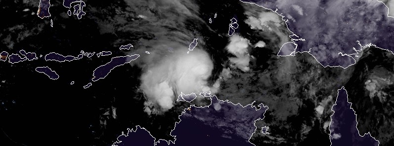
Featured image: Tropical low soon to be named Tropical Cyclone "Marcus" - March 15, 2018. Credit: JMA/Himawari-8
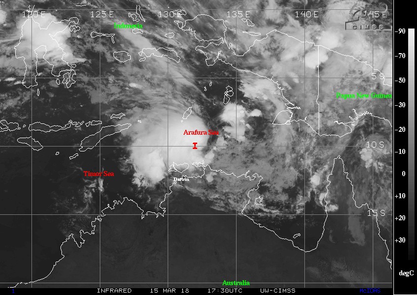
An intensifying tropical low north of the Tiwi Islands is moving southeast across the Arafura Sea and is expected to turn south towards the north coast of the Top End on Friday. This system is expected to reach Category 1 tropical cyclone intensity on March 16 and be named Marcus. This will be the 8th named storm of the 2017/18 Australian region tropical cyclone season.
The low is expected to reach tropical cyclone Category 1 intensity Friday evening (local time), BOM warns. The system will then turn towards the southwest during Saturday and move into the Timor Sea late on Saturday or early Sunday.
At 18:18 UTC on March 15 (04:48 ACST, March 16), the center of this system was located about 230 km (143 miles) NE of Milikapiti and 165 km (102 miles) NNW of Croker Island, Australia. Sustained winds near the center were 65 km/h (40.4 mph) with wind gusts to 95 km/h (59 mph). The low was moving southeast at 12 km/h (7.4 mph).
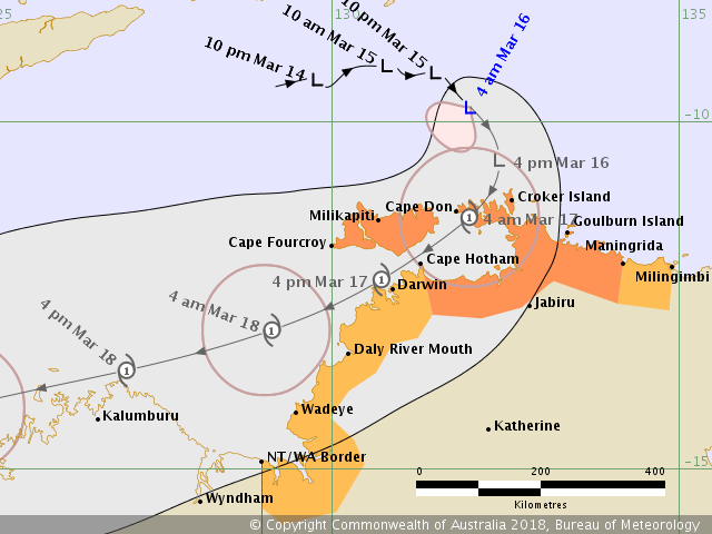
Tropical low soon to be Tropical Cyclone "Marcus" forecast track by BOM at 18:21 UTC March 15, 2018
This storm could bring wind gusts of up to 125 km/h (77.6 mph) and heavy rainfall to areas from Milingimbi to Daly River Mouth, including the Tiwi Islands and Darwin, BOM said.
Impacts on Darwin are expected late Friday evening with the potential for up to 200 mm (7.8 inches) of rainfall in 24 hours.
"Gale force winds and heavy rain at this time of year could result in some trees coming down, and possible disruption to power, telecommunications and transport routes," BOM's Acting Northern Territory Manager Jude Scott said.
A Flood Watch will also be issued for northwest coastal rivers Friday afternoon (local time).
Residents in affected areas should listen to the advice of emergency services and follow preparation guidelines set out by the Northern Territory Emergency Service.
Gales may develop between Cape Hotham and Daly River Mouth, including Darwin, during Saturday morning if the tropical cyclone passes through the Van Diemen Gulf and maintains intensity. However, if the tropical cyclone crosses the coast east of the Cobourg Peninsula Friday night, the tropical cyclone will likely weaken before approaching Darwin, reducing the chance of gales being experienced. As the system moves into the Timor Sea later on Saturday, gales may develop further south along the coast to the NT/WA Border.
A storm tide between Milikapiti and Maningrida, including the Van Diemen Gulf, is expected as the cyclone center crosses the coast tonight. Tides are likely to rise significantly above the normal high tide, with damaging waves and dangerous flooding Friday night and into Saturday morning.
Heavy rain is expected to develop along the north coast later on Friday, then extend into the northwest Top End on Saturday.
NTES advises residents from Cape Hotham to Maningrida, including the Tiwi Islands:
- Be ready for wet and windy conditions to arrive in your area;
- Finalise your home preparations;
- Check your family, friends and neighbours understand and are prepared;
- Move indoors and take shelter as the weather deteriorates.
NTES advises communities from WA/NT Border to Cape Hotham and Maningrida to Milingimbi:
- Prepare your home, yard and family for a cyclone, finalise your emergency kit;
- Decide NOW where you will shelter – at home, with friends or family, or a public shelter, where available;
- If you plan to leave the area, leave while it is safe to do so.
Further advice on cyclone emergencies is available at www.securent.nt.gov.au
Please ensure that friends, family and neighbors have heard and understood this message, particularly new arrivals to the area.
I'm a dedicated researcher, journalist, and editor at The Watchers. With over 20 years of experience in the media industry, I specialize in hard science news, focusing on extreme weather, seismic and volcanic activity, space weather, and astronomy, including near-Earth objects and planetary defense strategies. You can reach me at teo /at/ watchers.news.
Commenting rules and guidelines
We value the thoughts and opinions of our readers and welcome healthy discussions on our website. In order to maintain a respectful and positive community, we ask that all commenters follow these rules.