
Hurricane “Ernesto” to pass near Newfoundland, Canada before racing toward Europe
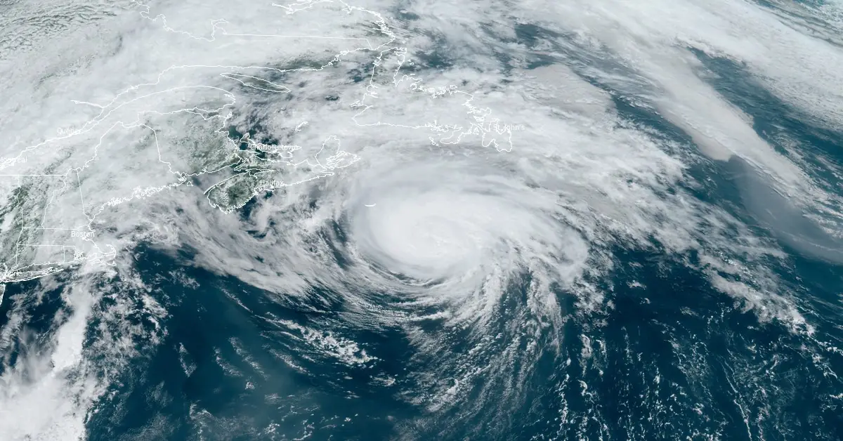
Featured image: Hurricane "Ernesto" at 16:50 UTC on August 19, 2024. Credit: NOAA/GOES-East, RAMMB/CIRA, The Watchers
Hurricane “Ernesto” made landfall on Bermuda’s western coast as a Category 1 hurricane at 09:00 UTC on August 17, 2024. The storm brought maximum sustained winds of 140 km/h (85 mph), heavy rainfall, large surf, and a dangerous storm surge. On the latest forecast track, the center of Ernesto will pass near southeastern Newfoundland tonight, August 19, and early Tuesday, August 20. After that, Ernesto will weaken and race toward Europe.
- Swells generated by Ernesto continue to affect Bermuda, the northeastern United States, and Atlantic Canada, posing life-threatening surf and rip current conditions.
- Beach goers should be aware that there is a significant risk of life-threatening surf and rip currents, and should stay out of the water if advised by lifeguards.
- Large breaking waves could cause coastal flooding in southeastern Newfoundland, particularly along southwest-facing shorelines from Burin to Avalon regions.
- While no coastal watches or warnings are currently in effect, residents in southeastern Newfoundland are advised to monitor the storm’s progress.
Despite the severe weather, Bermuda, with a population of 64 000, reported no significant injuries or major property damage. However, 71% of the territory’s 36 000 power customers experienced outages, and there was widespread flooding and downed trees.
Lyndon Raynor, a risk management official, reported that there were no major incidents or property damage calls, with most reports involving flooding.
“I’m happy to report that there have been no calls for service for any major incidents or damage to any property, and those calls that we’ve received over the last six hours or so are primarily flooding,” Raynor said.
While Bermuda reported no fatalities, powerful rip currents and dangerous beach conditions along the coast of the United States were blamed for the deaths of two people in South Carolina on Friday, August 16.
According to Capt. William Angelo of the Beaufort County Sheriff’s Office, officers responded to a possible drowning call at 10:28 LT. However, when the officers arrived, they saw beach patrol and paramedics performing CPR on a 65-year-old man who later died. The second fatality was as 73-year-old man who drowned on Friday afternoon (LT).
“Both of them, appears they got caught up in the rip currents,” Angelo said.
Ernesto weakened into a tropical storm early August 18 and re-strengthened into a hurricane again at 21:00 UTC on August 18. At the time, it was located 840 km (520 miles) S of Halifax, Nova Scotia, and 1 310 km (815 miles) SW of Cape Race, Newfoundland, Canada.
At 15:00 UTC on Monday, August 19, its center was located about 515 km (320 miles) SE of Halifax and 695 km (430 miles) SW of Cape Race.
The system had maximum sustained winds of 150 km/h (90 mph), minimum central pressure of 968 hPa, and was moving NE at 44 km/h (28 mph).
A turn toward the northeast and east-northeast with an increase in forward speed is expected during the next couple of days.
On the forecast track, the center of Ernesto will pass near southeastern Newfoundland tonight and early Tuesday.

This re-intensification phase is expected to be shortlived and Ernesto is expected to become a post-tropical cyclone by early Tuesday.
Swells generated by Ernesto are still affecting Bermuda, the northeast coast of the United States, and Atlantic Canada. Life-threatening surf and rip current conditions are likely to continue in these areas during the next day or so.
In addition, in southeastern Newfoundland large breaking waves could bring the possibility of coastal flooding, particularly along southwest-facing shorelines from Burin east to Avalon regions. Please consult products from your local weather office, and stay out of the water if advised by lifeguards.
There are no coastal watches or warnings in effect but interests in southeastern Newfoundland should monitor the progress of Ernesto, NHC forecasters said.
After passing near Newfoundland, Ernesto will start weakening and then race across the Atlantic Ocean toward the United Kingdom where it is expected to arrive late Wednesday, August 21, or early Thursday, August 22.
“Even though some of Ernesto’s structure will change, it will still be a formidable storm that will raise winds and seas well away from its center and produce heavy rain along its ongoing track,” AccuWeather senior meteorologist Alex Sosnowski said.
Depending on how much of the wind and rainstorm survives the trek across the United Kingdom, stormy conditions may move on to affect part of northwestern Europe late this week, Sosnowski said.
References:
1 Hurricane Ernesto Advisory Number 32 – NWS/NHC – Issued at 15:00 UTC on August 19, 2024
2 2 men drown in South Carolina as Hurricane Ernesto produces rip currents along East Coast – FOX Weather – August 17, 2024
3 Ernesto to swipe at Newfoundland before speeding toward UK – AccuWeather – August 19, 2024
I'm a dedicated researcher, journalist, and editor at The Watchers. With over 20 years of experience in the media industry, I specialize in hard science news, focusing on extreme weather, seismic and volcanic activity, space weather, and astronomy, including near-Earth objects and planetary defense strategies. You can reach me at teo /at/ watchers.news.
Commenting rules and guidelines
We value the thoughts and opinions of our readers and welcome healthy discussions on our website. In order to maintain a respectful and positive community, we ask that all commenters follow these rules.