
Western Cuba braces for Rafael’s destructive impact on Wednesday
Western Cuba braces for impact as Rafael nears hurricane strength, expected to bring destructive waves and a dangerous storm surge when it makes landfall on Wednesday, November 6, 2024.

Satellite image of Tropical Storm "Rafael" at 13:00 UTC on November 5, 2024. Credit: NOAA-GOES-East, RAMMB/CIRA, The Watchers
Tropical Storm “Rafael” formed in the Caribbean Sea on November 4 as the 17th named storm of the 2024 Atlantic hurricane season.
Rafael is said to be near hurricane intensity when it passes over the Cayman Islands by Tuesday night (LT) where damaging hurricane-force winds, a dangerous storm surge, and destructive waves are expected.
The system should reach western Cuba and the Isle of Youth on Wednesday. A hurricane warning is in effect for this region, where a dangerous storm surge and destructive waves are also expected.
Tropical storm conditions are expected in Jamaica through early this afternoon (LT). Similar conditions are possible in the Lower and Middle Florida Keys beginning late Wednesday or Wednesday night, November 6.
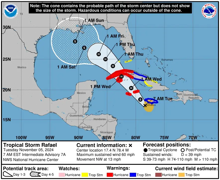
“It is too soon to determine what, if any, impacts Rafael could bring to portions of the northern Gulf Coast,” NHC forecaster Pasch said and urged residents in this area to regularly monitor updates to the forecast.
Rafael will bring areas of heavy rain across portions of the Western Caribbean through early Thursday, including the islands of Jamaica and the Caymans, along with southern and western portions of Cuba.
Flash flooding and mudslides are possible along the higher terrain in Jamaica and Cuba.
Heavy rainfall will spread north into Florida and adjacent areas of the Southeast United States mid to late week.
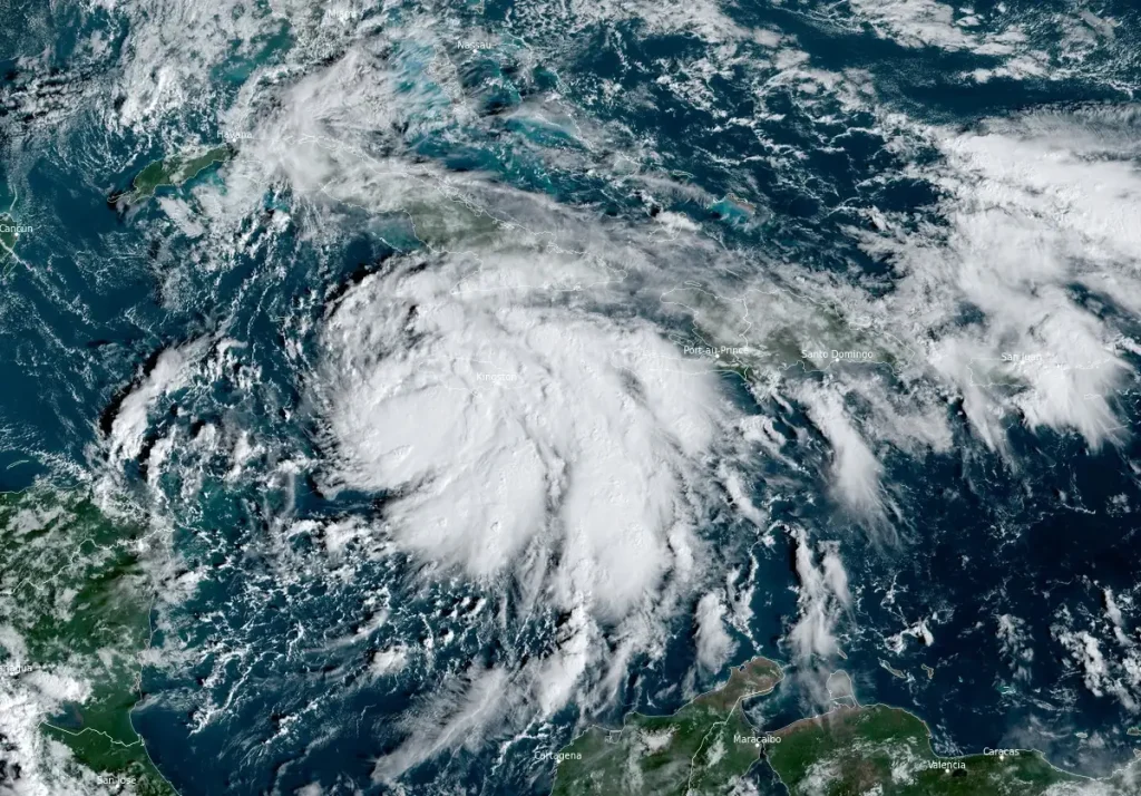
At 12:00 UTC on November 5, the center of Tropical Storm “Rafael” was located 130 km (80 miles) SSW of Montego Bay, Jamaica, and 370 km (230 miles) SE of Grand Cayman. The system had maximum sustained winds of 95 km/h (60 mph) and a minimum central pressure of 993 hPa.
Rafael is moving toward the northwest near 20 km/h (13 mph) and a generally northwestward motion is anticipated over the next few days.
On the forecast track, the storm is expected to move near Jamaica this morning, be near or over the Cayman Islands tonight, and be near or over western Cuba on Wednesday.
Rafael is forecast to become a hurricane in the northwestern Caribbean near the Cayman Islands with further strengthening before it makes landfall in Cuba.
Heavy rainfall is forecast across the Western Caribbean through early Thursday, with significant impacts expected in Jamaica, the Cayman Islands, and southern and western Cuba.
Rainfall amounts of 75 – 150 mm (3 – 6 inches) are expected, with localized totals of up to 254 mm (10 inches) possible over elevated areas in Jamaica and Cuba, which could trigger flash floods and mudslides.
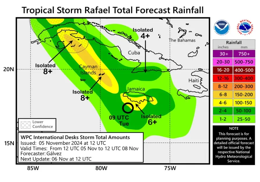
Rainfall totals of 25 – 76 mm (1 – 3 inches) are forecast for the Lower and Middle Florida Keys, spreading into Florida and nearby southeastern U.S. areas later this week.
Minor coastal flooding is expected in Jamaica tonight. Rafael’s storm surge could elevate water levels by 0.3 – 0.9 m (1 – 3 feet) in the Cayman Islands on Tuesday, with southern Cuba, including the Isle of Youth, potentially seeing surges of 1.8 – 2.7 m (6 – 9 feet) in areas of onshore winds. The Lower Florida Keys could experience water rises of 0.3 – 0.6 m (1 – 2 feet).
Tornadoes may develop over the Florida Keys and southwesternmost Florida mainland on Wednesday.
Swells generated by Rafael are expected to impact the western Caribbean in the coming days, potentially creating hazardous surf and rip currents.
References:
1 Tropical storm Rafael Intermediate Advisory Number 7A – NHC – Issued at 12:00 UTC on November 5, 2024
The Watchers team and our contributors bring the latest on extreme weather, earthquakes, volcanic eruptions, space weather, and all things science. We're all about making sense of the natural world and keeping you informed on what’s happening. Got a tip or a question? Hit us up using the form at newstips!
Commenting rules and guidelines
We value the thoughts and opinions of our readers and welcome healthy discussions on our website. In order to maintain a respectful and positive community, we ask that all commenters follow these rules.