
Subtropical Storm “Patty” impacting the Azores
Subtropical Storm “Patty” formed over the northern Atlantic at 09:00 UTC on Saturday, November 2, 2024, prompting the Azores Meteorological Service to issue Tropical Storm Warnings for all islands of the Azores at 12:05 UTC.

Satellite image of Subtropical Storm "Patty" at 10:20 UTC on November 3, 2024. Credit: EUMETSAT/Meteosat, Zoom Earth, The Watchers
At 15:00 UTC on November 2, the center of the storm was located about 480 km (300 miles) WNW of the Portuguese archipelago of the Azores, moving southeast at 20 km/h (13 mph). Maximum sustained winds were recorded at around 100 km/h (65 mph).
The storm had a minimum central pressure of 982 hPa, with winds of 66 km/h (40 mph) extending up to 330 km (205 miles) from the center.
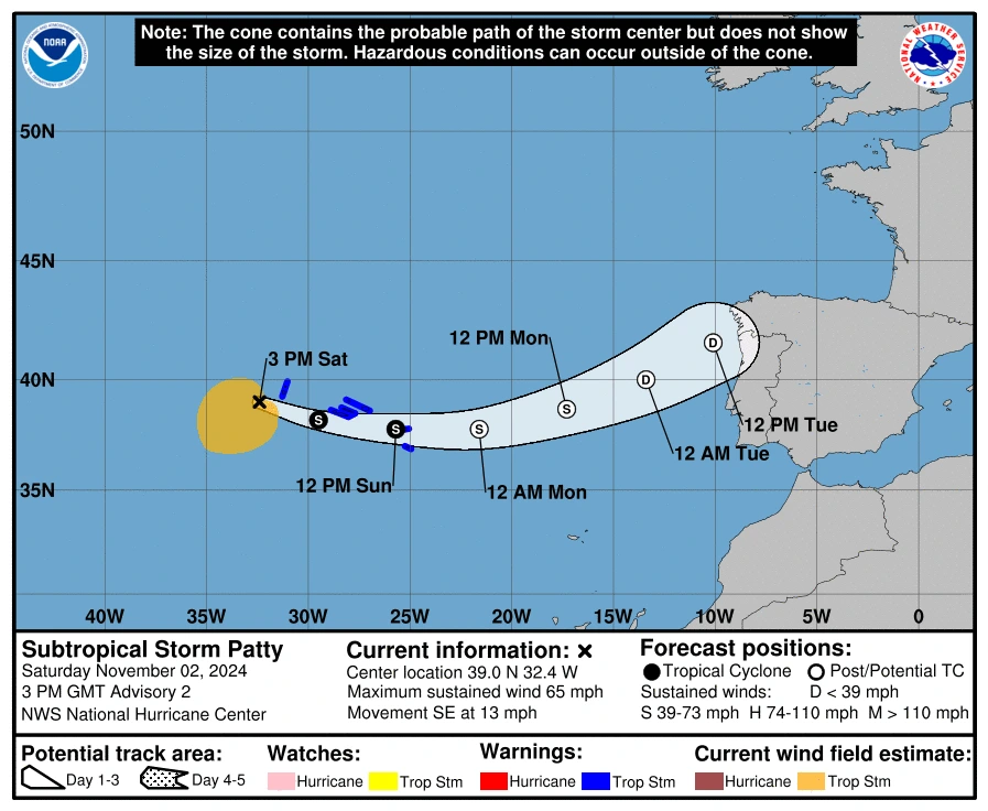
Patty approached the Azores by 21:00 UTC on Saturday with maximum sustained winds of 100 km/h (65 mph) and at 03:00 UTC on Sunday, November 3, its center was located about 115 km (75 miles) SSW of Lajes in the Azores. The system had maximum sustained winds of 95 km/h (60 mph) and was moving E at 31 km/h (20 mph).
At 09:00 UTC on Sunday, Patty’s center was very near Sao Miguel Island (population 140 000) — the largest and most populous island in the archipelago.
Forecast models indicate that Subtropical Storm “Patty” will continue moving eastward to east-northeast over the next few days. This trajectory is expected to bring the storm near the southeastern Azores later today. Residents in these areas should prepare for weather impacts as Patty draws closer.
The storm’s intensity has decreased, with maximum sustained winds now recorded at 85 km/h (50 mph), though stronger gusts may still occur. Continued weakening is expected, and Patty is forecast to become a post-tropical system by early Monday, eventually dissipating by midweek. This transition should result in a gradual reduction of impacts over the affected regions.


Currently, winds of 65 km/h (40 mph) extend outward up to 280 km (175 miles) from the storm’s center, primarily to its south and southwest. The estimated minimum central pressure stands at 989 hPa.
Wind conditions in the Azores are anticipated to reach tropical storm levels throughout the day, bringing potentially hazardous gusts.
Rainfall across the Azores is expected to range between 25 and 50 mm (1 to 2 inches), with some localized areas potentially receiving up to 100 mm (4 inches) through early Monday. This could lead to minor flooding in vulnerable locations.
Additionally, swells generated by Patty are expected to affect the Azores through tonight, with a significant risk of dangerous surf and rip currents.
Residents in affected areas are urged to monitor the situation closely and stay informed through updates from their local weather services.
Whatever is left of Patty will reach northern Portugal and Spain by late afternoon (LT) on Tuesday, November 5.
References:
1 Subtropical Storm Patty advisories 1 – 5 – NHC – November 2 and 3, 2024

I am an Assistant Editor and Severe Weather & Science Journalist at The Watchers, specializing in real-time severe weather coverage, geophysical event reporting, and research-driven scientific analysis. You can reach me at rishav(at)watchers(.)news.
Commenting rules and guidelines
We value the thoughts and opinions of our readers and welcome healthy discussions on our website. In order to maintain a respectful and positive community, we ask that all commenters follow these rules.